


Communications networks, unitary systems and calculators in the Inca civilization
How is it possible then that a village of five centuries ago could have an exact census of its inhabitants in a wide territory that goes from Colombia to Argentina, in the same Andean mountain range?
Some facts about the Incas
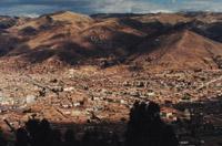
At first, the Incas were one of the small groups living on the shores of Lake Titicaka. It seems that due to the continuous struggles between these peoples, the Incas moved to the fertile valley of Cuzco, where, according to legends, took that name in the year 1100 when they built the city. At that time, the Inca culture was similar to that of other Andean peoples, who used hoe farming, irrigation and fertilizers and knew the techniques of clay, textile and precious metal smelting, but did not come to equate at all to those of Motxika or Nazka. However, unlike the villages of the neighborhood, the Incas developed a unique characteristic: their unlimited organizational capacity, which allowed them to create and structure one of the great known empires. They materialized the economic, political and social organization of the many territories that were part of the Empire.
Road network and communications system
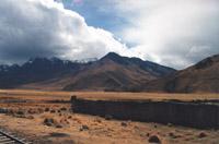
If we look at the network of roads they built, the Incas were able to organize things. Through the net, the farthest places of the empire were also linked to the capital. They consisted of two main roads, one inland from the northern border to Argentina, through the Andean highlands and valleys, and another along the coast, from Tumbón to the Chilean desert of Atakama. Between them there were several secondary roads, built perpendicularly to the main ones, which were used to link. All these roads allowed the empire to pass in no time. Also, some runners, the chasquis, who worked in turns, did the work of the “postmen”, and they did it quickly and without errors. In the valleys, the general width of the roads was four meters, and they were very well located. The Andean steps were narrower and in some cases exceeded the great slopes through the rock steps. On the roads there were signs called moles; the moles of a road were always separated by the same stretch. On the other hand, in the strategic points of the roads were placed tambos, towers of protection of stone, in which food, drink and ears were left for the travelers, as well as the changes of turn made by the corridors that acted as postmen. To cope with the great gorges of the rivers bridges were used; when the distance to overcome was small, the bridge was a single slab and when the stretch was greater hanging bridges were built.
Road drawing
In order to make the distances in the shortest possible time, the road drawing was carried out, when possible, by straight lines. Therefore, it is not surprising that the tours go up and down hills, summits, slopes, valleys, etc. Also, in the selection of itineraries were sought areas of easy drainage to avoid the deterioration of the roads. As mentioned above, the main roads were longitudinal and consequently coinciding with the directions of the mountain ranges, which traverse several high summits.
The width of the roads ranged from 2.5 to 6 meters. When they had to face the slopes, which often happened, ramps were used if the slope was not very steep, and in other cases stairs were built; the steps of the stairs, which separated 30 cm away, always leaned downwards. The marshes were covered with stone and sand, making a roadway. Signs of wood and moat were placed in the deserts of the coast to prevent the loss of passengers. In the valleys high walls were built so as not to deteriorate the roads. In rainy and swampy areas drainage systems were invented that served as strips to avoid pochis and mud. In addition, they had the walkers who took care of the maintenance of the roads, which was called mitayo. All longitudinal and transverse roads covered a length exceeding 30,000 km.
Chasquis and tambos
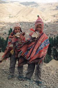
Thanks to the corridors or chasquias, the news soon reached the cities and towns of the Empire. When Chasquía arrived at a place where the turn was changed, he did not stay there, but kept running along with the other chasqui that had to take the turn. To change the turn correctly, the chasqui that was arriving informed of his arrival through the pututos (snail horns). The relay was always prepared on the drum, with sandals, pouch on the back and body wrapped in the head. Once he heard the sound, he went to the search of the other and, in front of them, without stopping running, they advanced gathering the message that one had given them. They also had another way of making the call, but they used this method only for emergency cases, especially for riots: they made smoke signals by day and lit night fires. Chasqui always had special woods to light the fire.
The length of the fixed distances that the corridors had to travel varied according to the type of terrain, being in the plains longer than in steep or difficult areas. The speed they got is to stand out. There are several examples of this: for example, in the chronicles of Gutierrez de Santa Clara and Pedro Pizarro, there are letters sent from Cuzco to Quito (approximate distance of 2000 km) that only took five days to reach the finish.
Unit systems
In order to control the taxes to be paid by the land and the inhabitants, it was necessary to have a system of measures that defined the extension of the property of each person, as well as a calendar in which agricultural affairs and celebrations were fixed. Finally, it was necessary to count, add, remove, multiply and divide a calculation system.
The measures used by the Incas were based on the parts of the human body. Two of its longitudinal units were male and braza, the first equivalent to about 20 cm and the second to 160 cm. The braza was the measuring unit of the land and a full braza bar was used as an official measuring tool. They had a unit called passage to measure travel distances of about 13 meters. There was also another, larger unit, which was commonly used on roads, is a mole, equivalent to 6,000 steps (78 km).
Another unit of the same name was used to measure surfaces. However, it is not clear what was the equivalence of a particular terrain. It can have an area of 50 bracelets x 20 bracelets (2,560 m2).
As for the volume, the Incas measured the grains in units called phoqca –29 liters approx. But they had no measures to measure liquids.
In the case of time measurement, it is worth mentioning that the Inca calendar was corrected annually. The calendar began in the December solstice, observing the locations of the solar shadows of the four towers located east and west of Cuzco. The observations were made from the tablado installed in the main square of Cuzco. In the southern hemisphere, since the December solstice is the longest day of the year, it was easy to determine when that day arrived; that day, at sunrise and sunset, the shadows of the towers reached the extreme signs of the square. The year was distributed in 12 months of 30 days, reserving the remaining five for the two most important Inca celebrations: the solstices of December and June. The calendar established when the land was cultivated, when the seed was sown and when it was harvested. The days of celebration of ritual worship and other festivals were also well defined.
Incas quipus or calculators
The Quipus, besides being an unbeatable tool to make calculations, were a way to keep the news of the main events. Since the Incas did not work in writing, they took advantage of the following tools.
The Quipus was composed of a main string and other colored strings suspended from it. Some quipus were used to save numbers and add to the decimal system. The quantities were expressed in those other suspended ropes of the main rope, as follows: with such a rope, the set of knots further away from the main rope was the indicator of the individuals, the contiguous group, the ten, and thus, going towards the main rope, all the others. If there were no knots where it was needed it wanted to indicate zero. It should be noted that, at present, in some places of the Andes the quipus is used to count or to express the widths of the territories.
Since the knots of the strings were always equidistant, the sums could be performed easily, so they are considered as calculators. According to the chroniclers of the time, when they wanted to make more complicated calculations, they used square tables in which stones were placed. This system was similar to that of abacus.
They also used Quipus as a mnemonic method to tell stories, genealogy or liturgy. There were people with quipus reading skills, called quipucamayac. They learned the statistical, historical and liturgical information received by the government and when they were called by the authorities they were told by heart.
Chroniclers cholos
All we know today about the Incas and pre-Inca peoples is due to archaeological research, the writings of the Spanish conquistadores and the writings of the natives. These writings were made both in Spanish and translating their language, Quechua, into the Spanish alphabet. The first grammar on Quechua was published in 1595, since, after the arrival of the Spaniards in these areas, some made an effort to learn the language. Once the Spaniards settled in the Inca territories, the mixture began to appear, accompanied by chroniclers cholos. The cholos were half Incas half Spanish. One of the most outstanding cholos was the Garcilaso de la Vega, called "Inka". Garcilaso de la Vega was the son of an Inca princess and a noble Spanish soldier. Therefore, he knew very well of the Quechua language, and later studied Spanish, Italian and Latin; he helped his father translate works written in Italian. In Real Comments, written by Garcilaso, you can read various Inca customs and stories. The sections that act on the measurement systems and the use of the quipus stand out. According to the author, he was able to read the quipus and clarify what was there, but unfortunately he thought the method was too difficult to understand by people, so he gave no explanation about it in the book.
Garcilaso de la Vega also collected the phrases of the Inca Pachacutec, among which he highlighted: "He who tries to count the stars of the sky, not knowing how to count the knots and the cruel ones of the quipus, only gives inside".
However, neither Garcilaso nor Pachacutec knew that quipus would be replaced by efficient calculators and computers, and that the role of the Inca roads is currently fulfilled by information highways. They didn’t know we started counting stars…
Buletina
Bidali zure helbide elektronikoa eta jaso asteroko buletina zure sarrera-ontzian


