


Devices that do not leave temperate
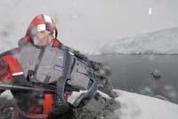
If in Antarctica we fall to the sea without any protection, the man will not survive more than three minutes. But the frozen continent is too tempting for research, to avoid it. The most cutting-edge technology has allowed hundreds of scientists to survive in optimal conditions, as well as conducting research that, despite their excellent situation, are common to them.
Many of these scientists live on a boat. They are not containers of common use, but they must be able to break the ice. The German Polarstern, for example, is capable of sailing through ice up to a metre and a half thick. It has four engines that can reach a force of up to 14.000 kilowatts, which gives it a power and a high speed (able to travel almost 30 kilometers per hour) that allow to break this type of ice plates.
Polarstern is made of a special steel capable of withstanding 50 degrees under zero. In fact, common steel usually becomes fragile when reaching ten degrees below zero. However, the increase in nickel concentration in steel reduces this fragility and improves mechanical properties by increasing the carbon concentration.
Pointer boat
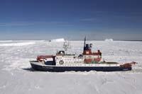
Polarstern is the most sophisticated of its packaging. He is responsible for the Alfred Wegener Marine Research Pole of Germany
In fact, the Institute's logistics chief, Dr. Uwe Nixdorf, explains why Polarstern is so special: "In addition to breaking the ice, it unfolds in high seas. This is necessary, since it goes back and forth between the Arctic and Antarctica. Other ships specialized in breaking the ice rise and fall sharply in high sea. Other research vessels are unable to break the ice." Thanks to its side propellers, bow and stern, vertical stabilizers and a special system that prevents sudden movements, Polarstern also operates on the high seas.
On board are carried out investigations focused on eleven areas, with all the instruments that it entails. Noteworthy is the Hydrosweep DS II ultrasound, which includes data for marine mapping, among others. It is ideal for deep seas, such as Antarctica, as it is also capable of taking data located 10,000 meters below sea level.
"The multi-ray echo Hydrosweep DS II uses 59 rays, each of which performs an individual sweep of the marine bottom", explains Dr. Saad El Naggar, logistics employee of the Institute. "The sum of all these rays provides deep information on the seabed at a wide angle of 90 or 120 degrees depending on the depth of the sea."
Another of the most innovative tools they have used in the Polarstern is the First Navy system, which detects whales through infrared thermography. It was first tested in July last year. This system takes advantage of the heat released by the whales when breathing. Dr. Olaf Boebel, head of the oceanic acoustics research team, has given details: "Infrared thermography records heat radiation from each body. It shows it on a screen in black and white. The clearer a point, the warmer it is. And the hot jet of a whale is easily separated from the cold waters of Antarctica."
Volcano in three dimensions
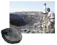
The lightning technology is used not only in the coldest place in the world, but also in the hottest. For example, to represent the interior of a volcano. This was done by Dougal Jerram, professor of the Earth Sciences department at the University of Durham, during his expedition to the Afar triangle with several members of the BBC television network. The Afar triangle is located in Ethiopia, right next to the so-called Horn of Africa. Geologically it is located in a very unstable area and will be devastated once by the Red Sea. Being the hottest area on earth, Dr. Jerram himself suffered a temperature of up to 55 degrees at the end of 2007.
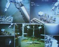
The main objective of the expedition was to remove for the first time the three-dimensional image of an active lake of lava. For this purpose, for the first time in history, it was necessary to introduce an equipment of 80 kilos in the crater of a volcano, the Erta Ale. This equipment consisted of the manufacture of a laser scanner. "The scanner sends millions of laser beams at a 360 degree angle to build a virtual photo of the environment," explains Dr. Jerram. This scanner has incorporated a simple photo camera and, comparing the numerous points sent by the laser beams with the images obtained by the camera, a real color is given to the three-dimensional image.
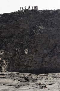
As Dr. Jerram pointed out, the most difficult task was to transport a team of 80 kilos. To reach the summit of the volcano they used camels, but the process from the edge of the crater to the interior was in the hands of man. Yes, with the technology: "We used a P640 thermochamber to see which area of the crater was the temperature out of safety measures." This camera uses infrared rays and when making the screen of what records, performs a reproduction according to the temperature of each zone, using different intensities of color. Thanks to this camera, the members of the expedition were able to know beforehand the areas to avoid when entering the crater, especially for its heat and dangerousness.
Once all the measures were taken and scanning well the outside of the crater, there was nothing more to put on the protective suit against the heat and descend through the crater with the tooling. With this last step, the challenge was already overcome, since for the first time it was possible to put an artiluge in a volcano and scan a lake of lava in three dimensions. However, Dr. Jerram had another challenge and used a last device when he was down: "We tried to measure the temperature of the volcano by means of a thermocouple capable of reaching a temperature of up to 1,500 degrees. The magma had about 1,150 to 1,200 degrees."
It says more or less, because it finally did not achieve its goal: it could not launch the thermocouple long enough to enter well into the magma and reach its temperature. The most cutting-edge technology also has its limitations.
Buletina
Bidali zure helbide elektronikoa eta jaso asteroko buletina zure sarrera-ontzian


