


The world at your fingertips
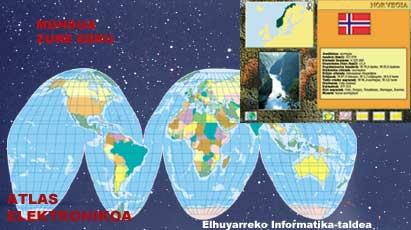
First, Elhuyar published in late June the CD-ROM entitled “Electronic Atlas of the World”.
In recent years, computer science, and especially the multimedia area, has acquired an undeniable importance. Elhuyar began to work this way a few years ago and intends to continue deepening in the future. Therefore, when last year we published the Basic Geographic and Political Atlas in a classical way (that is, in book format), we realized the need to work and place this type of materials through multimedia applications in these new media. We did not want to dismantle the scope of books at all, but seeing the opportunity to go further, it seemed necessary to take advantage of the advantages offered by the new techniques when working on the information of maps, photos, sounds and texts. You now have the last word, the reader, because you will have to decide if the choice is right.
Terrace and spectacular
We place the project within the complementary materials for education, which forces us to develop a didactic product. When designing the CD-Rom we have aimed at Compulsory Secondary Education (ESO) students, which has led us to create a multimedia application and fulfill other characteristics. Thus, the simplicity of use, the friendly and representative graphics, the proper organization of the information and the clear presentation, the quick access and the possibility of navigating the information are the main characteristics of this work.
To start navigating the world
As for simplicity, the user can only access the information that interests him by clicking on the corresponding button. Since the product is aimed at young people between 12 and 13 years old, it has resorted to a pleasant and attractive work tool, for which images have been used that reflect the possibilities offered by the program at all times.
Taking into account the attitude of the recipient, we have organized the information into units of different levels. On the one hand there is the basic information (which will always be offered) and on the other hand the additional information will be offered (which will only be displayed when requested by the user). In this way, they are expected to meet different levels of curiosity.
As discussed above, the design is quite simple, allowing the requested information to appear directly on the screen. In addition, we can easily move from one topic to another or from one point to another in the world without backing down or moving forward on screens. It is what the average user calls comfort and in the computer language is called interactivity with the user.
Everybody before you
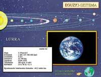
Let's sail. PC or Macintosh, the Atlas supports both systems, so we will discard it once for all compatibility issues. When you turn on the computer and open the program, the solar system appears before you. Click on any star and its mass, volume, density, diameter, etc. appear with a photo. After playing in the Solar System, you will also want to return to Earth, for this you will have to press on the small balloon that appears on Earth. You are right: that is the real access to the Atlas.

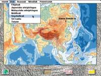
After an animation the world map is shown. At this point the user has different options. Visualize some maps worldwide (religion, climate, health, vegetation...) or introduce them to a continent on the map distributed on the continents, selecting the name in the menu or clicking with the mouse on the map. If possible, it is yours.
Embedded in each continent, the political map is the first to be seen, while listening to the typical part of local music. This map allows the user to access basic information (national information) and is therefore the map that appears first on all continents. You can also see the physical map by clicking on the corresponding button: in a menu appear the deserts, rivers, islands, seas, lakes, plains, capes, peninsula and main mountains of this continent, and selecting one will be located on the map.
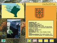
Returning to the political map, you can enter any state of the continent. Simply click on the map itself in the name of a particular state or select this name from the menu. This last track allows access without knowing the exact location of the state. What will you find there? In short, the basic information offered when entering a State is the local flag, the information summary (number of inhabitants, density, official languages, ethnic groups, capital, etc. ). ), location map and a photo. In addition, as mentioned above, complementary information will be provided: general information of the State, history, geography, economy, political structure and art. To access it you must click on the information button.
... and travels the world
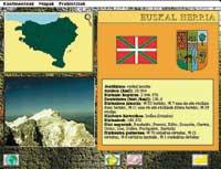
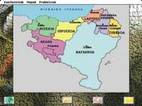
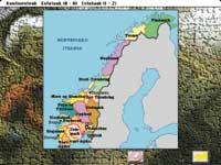
We have said on several occasions that the product we just published is the World Atlas. However, due to proximity criteria, special treatment has been offered to Europe and the Basque Country. In the European States, in addition to the above information, you can see the political map of the State with the main cities by clicking on the sea bass shown on the State Situation Map. In the case of Euskal Herria, as if it were a state, you can choose it through the menu or by clicking on the name on the European political map. In addition to the political map, basic and complementary information, the physical map is also offered.
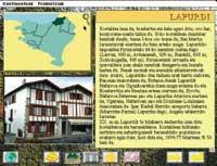
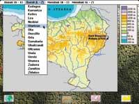
Moreover, the opportunity to deepen in each province. In addition to the usual information, we can analyze the origin of the population and the linguistic competence; instead of the flag, the shield of each province will be exposed and clicking on the bass of the map of situation of the province, the distribution of the province by counties is explained, where the name of a certain region is selected.
Buletina
Bidali zure helbide elektronikoa eta jaso asteroko buletina zure sarrera-ontzian


