


Announcing earthquakes
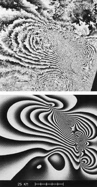
In the last two years, 785 kilometers high, the ERS-1 satellite of the European Space Agency revolves around the Earth. All over the world he sends radar images, but very interesting are those of the Mojave desert in California, which he sent on June 28, 1992. And then there was an earthquake in the desert.
Researcher Didier Masonet and his colleagues have used these images to see the deformations caused by the earthquake on the ground. Combining images before and after the earthquake can form an interferogram, that is, a map of the deformations of the terrain with a precision of 30 millimeters. Interferometry is a technique based on the extraction for each pixel of the phase differences between two images (before and after the earthquake).
The interferogram obtained is practically the same as that announced by a mathematical program made with data from the earth before the earthquake. This contrasting mathematical program or model will preserve earthquakes and volcanic eruptions.
Buletina
Bidali zure helbide elektronikoa eta jaso asteroko buletina zure sarrera-ontzian


