


Basque Coast (XI): Cliffs of Gipuzkoa
We are on the judicial border between Lapurdi and Gipuzkoa. If we move forward or back, there would be a lot of difference in our analysis. Between the cliffs on both sides there is much change, among other things, when we arrive at Gipuzkoa we will enter the areas of the Tertiary. This indicates that there will be many changes in the composition, structure and physiognomy of the coast.
For these characteristics, in Gipuzkoa we find conditions of isolation that do not occur in the cliffs of Lapurdi. This will allow human influence to be less, so we can affirm that the degree of conservation of the cliffs of Gipuzkoa is better. However, the Gipuzkoan coast is also a "victim" of the attraction that the sea generates in humans, although to a lesser extent than in Lapurdi. Unfortunately, this trend is being strengthened in recent years and is already worrying.
It can be a good time to start turning around this situation before it was too late. As you make this reflection, the reader will try to analyze the current situation of the cliff coast of Gipuzkoa.
From Cape Higer to Zumaia
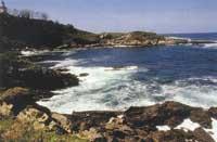
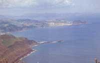
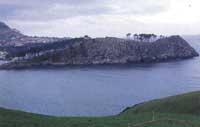
We start from the left bank of Txingudi Bay, which forms the mouth of the Bidasoa River, and start from the coastal section to Zumaia. Obviously, this section is very different from the one on the right of the bay. While the north coast (as indicated in the previous article) is almost perpendicular to the sea, the coast that begins on Mount Jaizkibel and ends on the cliffs of the right bank of Zumaia enters the sea with a small slope. Consequently, in this stretch of coast there appear the spectacular cliffs that can be needed in the girdle. In addition, the vegetation of this area has a wide coverage that reaches practically the level of the pleamar. On the other hand, the erosion of the wind is more pronounced in these cliffs and produces strange shapes in the stones.
Anyone who approaches this stretch of coast will realize what has been said so far. But why does this morphology occur? The composition and structure of the stones should be studied to understand it and, first, we will have to take into account the age of the cliffs. These rocks are relatively young, since they are formed by sediments of the Paleocene and the Eocene of the Tertiary. At this time, in the east and in the center the Pyrenees were quite raised, so the sediments made a small route before reaching the sedimentation zones. This phenomenon explains, therefore, the presence in this stretch of sandy marl coast and large layers of sandstone Flysch.
These characteristics and the low inclination of the strata make erosion in the cliffs of Gipuzkoa low. As a consequence, the geomorphological elements that produce differential erosion are here scarce. Among them, the most abundant appear as incisions. Its origin is found in the orogenic elevations, both by the main thrust lparralde/South and by the lateral coercion East-West.
It is believed that these uprisings waved the axis of the structure and fractures occurred in the areas that managed to overcome the flexibility of the materials. As a result, these areas were unprotected from erosive agents. Later, due to the ideal conditions for the rivers to reach the sea, there has been an increase in the phenomenon. The rise of the sea level at the end of the last glaciation made these valleys become a estuary full of seas. This can be seen today.
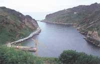
The cliffs of Gipuzkoa offer an excellent opportunity to observe in a practical way the results of the phenomena described. The most illustrative examples are the entrance and the cove of the port of Pasaia and the estuary of Orio. The bay of the Concha de San Sebastián and the Urumea estuary emerged in this way, but the erosive differential was stronger and, consequently, instead of a simple cut, another structure arose: a wide bay with two islands in the center (Santa Clara and Urgull).
At this point, we will be forgiven for a brief break in an environment worthy of special mention, the set formed by the bay of Zarautz and the island of San Antón de Getaria. As for the bay, it has been created on a diapiro that can explain this important entry to the Gipuzkoan coast. In addition, in this area the strata bend sharply turning with themselves, which has made this coastal strip more erosive. These phenomena and the strong strata of sandstone gave rise to the island of San Antón, today artificially tied to solid ground in front of Getaria.
From the ecological point of view, in this coastal section there is no open abrasion platform, so the surface of the mareal ecosystem is relatively reduced. The most suitable conditions for the development of this type of ecosystems are given in small coves formed at the mouth of numerous streams, which allows a greater extension of the area.
As for the ecosystem of cliffs, however, the situation is completely different. Its geomorphology establishes more comfortable living conditions for living beings and, as discussed at the beginning, its extension is very large. Although the typical plant gradient of these ecosystems is not very pronounced, vegetable coverage can reach almost the level of pleamar. And here we have to retake the island of San Antón de Getaria, where we find the only Gipuzkoan population of the species Limonium binervosum, considered as the typical plant of the calcareous lanva.
As for the fauna, on this coast are the three colonies of gulls of Gipuzkoa: that of Ulía (between the cape of Monpas and the street Murgita), that of Pasaia (from Murgia to Pasaia San Pedro) and that of Jaizkibel. Although the most abundant species is the Patiamarillo Gull (Larus cachinnons), the nidification of the Sombre Gull (Larus fuscus) is more and more pronounced and in recent years the nidification of some Argentic Gulls (Larus argentatus) has spread.
In addition, in this stretch of coast can be observed most of the nests of the Gipuzkoan pilgrim falcon (Falco peregrinus) and, as has already been indicated on the island of San Antón de Getaria, is assured the existence of large rocky gays (Monticola solitarius).
It should be noted, moreover, that the only population of the southern ranita (Hyla meridionalis) of the C.A.P.V. It appears on Mount Mendizorrotz, with two rather rare reptile species in the Jaizkibel: Verdinegro lizard (Lacerto schreiberi), endemism of the Iberian peninsula with oriental limit of its distribution in Jaizkibel, and green-yellow snake (Coluber verdiflavus), species typical of the Pyrenees.
Although it is not intimately linked to the cliffs, due to the special climatic conditions of the small streams that flow into the sea along the slopes of the Jaizkibel and Mendizorrotz mountains, we must mention the presence of tropical species (Woordwardia radicans, Stegnogramma pozoi, Dryopteris aemulo, etc. ). Undoubtedly, this can be another reason of weight for the protection of this stretch of coast subjected to speculation, fires and wild uses.
From Zumaia to Cape Endata
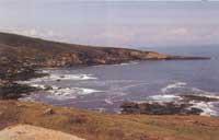
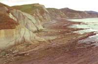
From Zumaia, the Gipuzkoan coast is again distorted and in it predominates a morphology similar to that of the cliffs of the grill: vertical cliffs and wide platforms of abrasion.
The reason for these similarities lies in the litology of the cliffs, part of the coast in which the Flysch structures appear again, composed of sandstones, marbles and, to a lesser extent, clays of the Middle and Superior Cretaceous, which were mentioned in the study of the lparrales.
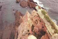
Specifically, around the Azkorri tip of Zumaia you can see the stratum that shows the transition between Mesozoic and Tertiary.
This unique stratum has made Zumaia a meeting point for geologists. In fact, within the stratum it is believed that there is an explanation of the expiry that occurred at the end of the Upper Cretaceous. Several prestigious researchers say that the high concentration of iridium that this stratum (and similar ones) explains would show that a huge meteorite hit the Earth.
According to this hypothesis, a cloud of dust that arose as a consequence of the collision covered the Earth for a long time, which caused sudden climatic changes and significantly affected the photosynthesis of the plants. For many species, it was impossible to adapt to new living conditions, which caused the disappearance of many species. In any case, this theory, briefly exposed, is only a hypothesis today and it must be taken into account that there are other hypotheses to explain the same phenomenon.
On the beach of Itzurun and in the cove of Aitzuri, there appears the pink flysch typical of the Upper Cretaceous, but as we move forward, as we move away from Aitzuri and approach Endata, the color becomes clear until the typical light of the Flysch of the Middle Cretaceous appears.
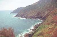
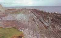
More than the color, the most important feature of this Gipuzkoan coastal section is its high erosion. In fact, the soldable limestone cement is very abundant in the area, which produces erosions on the cliffs. All this is provoking a decline of the coast much faster than elsewhere.
Proof of this rapid decline are vertical cliffs and hanging valleys. These valleys are due to the erosion of the cliffs is faster than that of the streams. Due to this phenomenon, the ends of the rivers are located 10-30 meters above sea level. For this reason, these streams flow into the mode of waterfalls (like the Endata stream) or sliding down the walls of the cliff (the rivers San Martin and Loiazu, for a church). This brings a high landscape value to the whole environment.
From the ecological point of view, it is said that the most important marine ecosystem in the whole Basque Country is that of this stretch of coast. In addition to the above mentioned landscape value, this affirmation is due to the ecological diversity existing in the immense abrasion platforms. Thus, special mention has been made of this environment in the "Catalogue of Enclaves and Natural Spaces of Importance of the Autonomous Community of the Basque Country", published by the Ministry of Environment of the Basque Government.
Sentence. The special mention has not attracted more protection measures and, on the contrary, some recent aggressions have endangered the balance of this rich ecosystem. Among these attacks stand out the human overexploitation and the pollution of the streams that pour. Regarding this last problem, it can be said that the Zakoneta stream, which collects the spills of the industrial estate of Itziar, has reached its high point.
On the other hand, the characteristics of the cliffs, that is, the steep slopes and the difficulty of access to them, prevent the extension of the vegetation and the implantation of animal communities. However, in these rocks it is assured that some birds nidify Belatz (Fako peregrinus) and Haitiz-enara (Hirundo rupestris).
From Punta Endata to Lekeitio
At the end of Endata, we will soon discover that a new area begins. From the area determined by a fault, the stones of the Middle Cretaceous predominate and the flysches acquire a rather dark color, because the carbonous matter is more abundant. This structure is called the Supraurgonian rocky ensemble. The composition of their flysch also varies notably, since the layers are formed by marbles and sandstones associated with clays and in some aspects appear clusters of quartzite gravel.
This composition makes these cliffs appear stronger in front of the drawer, which makes the delay of the coastline slower. However, large abrasion platforms can also be observed in some places, such as in Mutriku's Galdonamendi, which are witnesses of this delay.
Differential erosion is also quite remarkable in some places and can be cited the following examples:
- Due to the existence of siderytic stone drawers between Deba and Mutriku, several peaks appear: Arrilaba, Alkolea, etc.
- Port bay due to the great erosion of the Mutriku dam.
- Set of rocks affected by thick sandy strata of the area of Saturraran.
- Spectacular cliffs of Ondarroa formed by high density polygenic conglomerates.
From an ecological point of view, intertidal and cliff ecosystems appear throughout the coastal section. Due to its large extension and the relative conservation of the natural structure, the most important are those of Mutriku and Saturraran.
Access to these places is quite complicated by itself, which has favored this stretch of coast. In any case, the creation of a regulation that controls human pressure and building permits would be a very adequate step for these ecological values not to disappear.
Besides all this, it is worth mentioning that between Ondarru and Lekeitio, and more specifically on the cliffs of Berriatua and Mendexa, the climatic conditions of the short streams that flow into the sea are very special. In fact, the geomorphology of these small coastal valleys and the effect of mitigation of the sea make climatic conditions similar to the tropical ones. In the vicinity of Mendizorrotz and the Jaizkibel mountains you can also see some species of ferns. From the botanical point of view, therefore, it is a unique environment.
Buletina
Bidali zure helbide elektronikoa eta jaso asteroko buletina zure sarrera-ontzian


