


Main protected areas of the Basque Country
- URDAIBAI
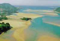
Level of protection: Biosphere Reserve: July 1989 Surface: 23,000 haLocation: The north of Bizkaia. The reserve comprises a total of 22 municipalities, bounded by the river basins of the Oka, Mape, Artigas and Laga rivers. It is a diverse environment modeled over the centuries by the activities of its people. In a small space we can find different types of ecosystems. The estuary, the coast, the holm oak and the archaeological sites stand out.
- URKIOLA
Level of protection: Designation: December 1989 Area: 5,988 haLocation: Southeast of Bizkaia and a small area of northeast Alava. The Natural Park includes the Aramotz-Ezkubaratz, Mugarra and Anboto mountains and the Sierra de Arangio. Forestry and grazing have been the driving force of the current landscape. It is a mountainous environment in which no urban core has settled. In the high mountains stands the mountainous landscape formed by limestone walls. Below, we will find extensive beech and grassland. Pine plantations that have been made throughout the Basque Country in recent years also have a large representation in Urkiola.
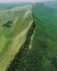
- VALDEREJO
Level of protection: Natural Park Designation: January 1992 Surface: Location: Western Alava. It borders the province of Burgos. Inside are the villages of Lahoz and Lalastra. Villamardones and Ribera, for their part, are no longer villages, since they had been emptied long ago. It is a wide valley surrounded by limestone walls. It has pine forests, beech and holm oaks on the slopes, while the valley has less and less exploited pastures. The valley gradually emptied, its inhabitants, the peasants, Vitoria and Miranda went to work. Since his appointment as Natural Park, man returns to Valderejo, but not to work...
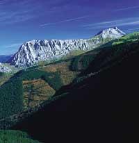
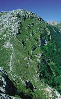
- GORBEIA
Level of protection: Natural Park Designation: June 1994 Surface: 20.016 haLocation: It is located on the border between Bizkaia and Araba. It has to the north the valley of Orozko, to the east the one of Arratia, to the south the valleys of Zuia and Zigoitia and to the west the freeway A-68 and the valley of Urkabustaiz. The top of the Gorbeia is a mountainous natural space in the centre. It has corners known by Basque mountaineers. The most outstanding ecosystems are the Altube beech, the karst environment of Itxina and the pastures of Gorbeiagane and Berretin.
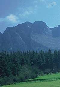
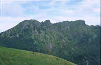
- ARALAR
Level of protection: Natural Park Designation: April 1994 Surface: Location: Southeast of Gipuzkoa. In the muga with Navarre between Bedaio and Ataun. Mountainous landscape formed by wide pastures. As many archaeological sites indicate, the human presence in this area is very ancient. Currently, grazing plays a fundamental role in the conservation of this landscape. Geologically we can also find corners of great value, the dome of Ataun, the glacier circus of Pardelutz, etc.
- AIAKO HARRIA
Level of protection: Natural Park Designation: April 1995 Surface: Location: Northeast of Gipuzkoa. Between the rivers Bidasoa and Urumea. It borders Navarre in the East. It is an area of great geological interest. There are some of the oldest materials in Euskal Herria. It is the Paleozoic Massif, before the Hertzian orogeny. Most of its forests are oriented from productivist exploitation. However, in Añarbe, Endara and Oianleku you can find remains of more natural forests. Another remarkable feature is the existence of ancient mines, such as the fine ones of Arditurri.
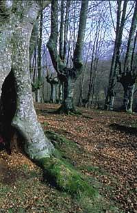
- BERTIZ
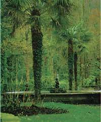
Level of protection: Natural Park Designation: March 1984 Surface: 2.040 ha Location: To the north of Navarre, on the banks of the Bidasoa River, it is located in the municipality of Bertizarana. It borders to the north with Etxalar, to the east with Baztan, to the south with the river Bidasoa and to the west with lands of Bertizarana. Within the park are the forests that have remained relatively natural. In 1392, since Pedro Miguel remained in the hands of Bertiz, many gentlemen have passed and have had less exploitation. Around the palace of Bertiz is the botanical garden created in 1847.
- URBASA-ANDÍA
Level of protection: Natural Park Designation: February 1997 Surface: Location: North of Navarre. To the north is the valley of Sakana, to the east the valley of Goñi, to the south the valley of Guesalaz, Lezaun and Abarzuza and to the west the valley of Araba.Characteristics: Pastoral and forest management is not new in these mountains. These ancient professions, rationally exploiting their resources, are pioneers of the current landscape. The Natural Park was declared after a long and controversial process.
Buletina
Bidali zure helbide elektronikoa eta jaso asteroko buletina zure sarrera-ontzian


