New NASA Earth Imaging Database
NASA has just published on the internet 13,000 spectacular images of the Earth. This important database is made up of photographs taken in the last 30 years by a multitude of NASA astronauts from different stations.
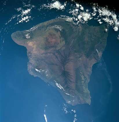
This image taken in August 1997 is the island of Hawaii. This island is as large as the North American state of Connecticut, with an area of 144 kilometers from south to north and 129 kilometers from west to east.
There are currently five volcanoes on the island of Hawaii. Those located north of the island (Mauna Kea, Hualalai and Kohala), although at the moment they are off, those of the south (Mauna Loa and Kilanea) seem alive.
The volcano that can be seen in the center of our image is Mauna Loa. To the northwest is the Smoke of Mauna, with a height of 10.650 meters. The oldest volcano on the great island of Hawaii is Kohala. As can be seen in the image, this volcano forms from the north to Mauna Ke a wide peninsula.
Click to visit the photo database
Buletina
Bidali zure helbide elektronikoa eta jaso asteroko buletina zure sarrera-ontzian