Belinda on ice
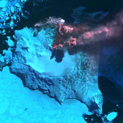
The top photo has been taken by the NASA Terra satellite through the ASTER radiometer. This instrument measures the emission and reflection of heat and is suitable for controlling volcanic eruptions. This is what is being studied: Eruption of Mount Belinda.
Belinda is located on the island of Montemos, in the South Atlantic, one of the South Sandwich islands, located halfway between South America and Antarctica, and totally under the ice. Until 1775 these islands did not appear on any map, but then saw British expeditions led by Cook and since then they are part of Britain. The British organization British Antartic Survey, dedicated to the investigation of Antarctica, has indicated that they are very pleased by the eruption, because the British lands are growing.
At the end of 2001, Belinda was followed with the warning of the MODVOLC service that controls volcanic activity. Since then, Terra has taken photos of great resolution twice a month. These images are very valuable to researchers, as they allow them to analyze the interaction between lava and ice. Among other things, they want to investigate what kind of rocks are formed.
In addition, they want to analyze the changes that produce the ice that melts. In fact, in 1996 there was a small eruption in Iceland under a glacier that melted as the ice poured into the ocean constituted the largest freshwater flow captured by the oceans, after the Amazon. On this occasion the eruption is greater and more ice is melting, so it can have a great influence in the middle. Soon they plan to record the activity of the island from the plane to have nearby images. Sure the images will be as exciting as they are interesting.
Buletina
Bidali zure helbide elektronikoa eta jaso asteroko buletina zure sarrera-ontzian