


Remote sensing
Considering the definition of remote sensing, a series of geophysical techniques would be included within it: seismic, electrical or magnetic measurements from planes, satellites or ships. However, geophysical techniques and remote sensing are easy to distinguish if we take into account the different electromagnetic fields they use.
While geophysics uses radiations of less wavelength (X-rays and gamma) or longer length (radio waves) than ultraviolet radiation, remote sensing only affects the lengths between ultraviolet and microwave waves. Thus, the definition of remote sensing is limited in the spectral field between 0.25 microns and 9 mm wavelength (Figure 1).

Electromagnetic radiation
Electromagnetic radiation consists of two fields (electric and magnetic), as a consequence of atomic activities. The interaction between matter and electromagnetic waves produces new radiations. These reflect the electrical and magnetic properties of the interposed matter. The nature and size of these waves are the subjects of remote sensing.

UM = ultraviolet
EI = visible spectrum
IG = infrared
But from the width of the electromagnetic spectrum, for the moment, remote sensing can only use narrow bands called atmospheric windows.
These windows are the result of the absorption capacity of electromagnetic waves that can contain the components of the atmosphere (Figure 2). Reduced in these atmospheric windows, remote sensing analyzes the energy supplied by the object. The form of energy emission can be basically of three types: own, reflected and provoked.
Radioactivity, especially gamma rays, is a form of self-emitting energy from the same object. The reflection of light is the passive form of the energy emission of objects.
The wavelengths identified in the infrared are the form of emission of the affected energy. This energy is produced by heating, which in turn produces perceptible vibrations of molecules.
Elements of remote sensing
The four main components that make up remote sensing are the power source, information unit, platform and sensor (Figure 3).

The energy source, in principle, is the sun and is reflected in the object of study of solar energy, also heating the object.
The information unit can be punctual, linear or superficial. The latter is the most used.
All objects that make up the basic surface transmit radiations that are stored in a single data.
The platform keeps the detector and it receives the energy from the information unit. The most widely used information units are aircraft and satellites.
The sensor is a device that captures electromagnetic radiation. These sensors can be both efficient and inert.
- The former emit energy and when they return, if they meet the object, they perceive it. The most widely used instrument is radar.
Since the radargraphies of Euskal Herria are not in our hands, we will not take this technique into account. - The seconds, the inerts, measure the amount of energy emitted by the units of information. Currently, the most used are the photo machine, TV camera and scaner (multispectral analysis tool).
Photo Machine
It was the start of remote sensing and remains the most widely used sensor. The three most effective factors in the development of photography are the objective, the grain size of the film and the type of emulsion.
In addition to being widely used among us, the abundant bibliography in this regard makes us unable to expand the information.
TV camera
The essence of television cameras used in remote sensing is the same as commercial television. It consists of a vacuum tube and a multicircular screen. This panel runs with a quick zigzag. Depending on the intensity of influence of the brush on photosensitive cells, different light wave emissions occur. The image capture process is the same.
The different types of tubes are made up of photoemitting or photoconductive cells. These cells (ultraviolet, visible and infrared) can act on different bands of the spectrum. The images obtained are sent to Earth and recorded in video or recorded on the platform itself.
Subsequently, magnetic strips are treated and analyzed. Some application of this sensor is well known among us: Images sent by the satellite METEOSAT. This satellite, due to its geostable orbit, has a fixed position at 36,000 km above Earth and offers constant images of the evolution of cloud masses.
Scaner or multispectral analyzer
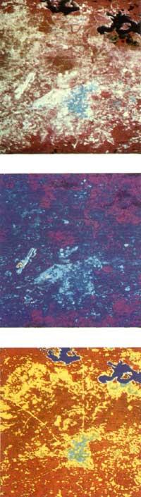
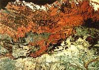
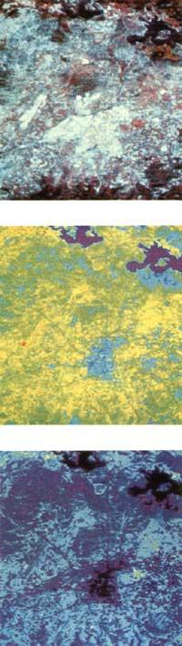
LANDSAT 4 MSS sensor, made on July 21, 1983. In these photos corresponding to the same place, the own or artificial elements of the city of Vitoria-Gasteiz and its surroundings are more or less distinguished.
Depending on the band or function entered, there are elements that separate more than others or vice versa. For example: geology, water, vegetation, land, public works, etc. Without using digital treatment, a basic study of the occupation of the soil can be carried out, limiting the different units that make up the soil, the development of these units and the interaction between them.
Although these are different types of scaners, we will briefly describe the mechanisms carried by LANDSAT satellites (carried out by MUELLE), since so far the information provided by these ships is the most used and have also served to build other satellites for the study of the Earth.
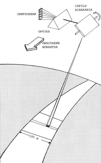
In short, the mechanism of the remote sensing satellite consists of rotating mirrors, optics and detectors (Figure 4).
The analyzer mirror oscillates around an axis parallel to the direction of displacement of the satellite.
Depending on the angular speed of the mirror and the speed of the satellite, it is possible to collect and analyze different field bands in the sensors; in the Landsat satellites this strip of areas is 185 km.
A complex optical system filters and selects the energy that attacks the mirror. This energy is sent by the list of fields analyzed. The electromagnetic waves filtered in the optical system are collected in sensors. Different sensors are used for each spectrum band.
Therefore, for the ultraviolet and visible spectrum silicon detectors and for the infrared cadmium teluro mercury detectors are used. Depending on the satellite 4, 5 or 7 sensors are transported. These detect specific wavelengths called bands. The different energies detected by each sensor in each band become electrical impulses. These measured variations in microvolts are sent to Earth for expansion and registration.
The surface information unit detected by the multispectral analyzer is called a pixel (picture ³). The synthesized information surface on each pixel is variable on each satellite: In the Landsat satellites the surface is 79 m x 57 m.
Regardless of any other factor, the pixel defines the resolution capacity of scaners, which in Landsat would be 79 m, that is, any object larger than 79 m is detectable in the image that occurs.
The recent French SPOT satellite has limited its resolution capacity to 30 m. Military satellites with much lower resolution capacity are also known.
Apps
There are many applications of remote sensing. As an example and taking into account only the scaner, the application of the TM sensor transported by LANDSAT 4 and LANDSAT 5 is mentioned. Regardless of the possible applications of different bands combined, the most suitable application for each band is:
- 1 Band: Mapping of coastal waters, difference between land and vegetation, differentiation of leafy and coniferous leaves.
- 2 Band: Reflection measures on the wavelengths of the green and information on the health status of vegetation.
- 3 Band: Differentiation between different types of plants based on chlorophyll absorption.
- 4 Band: Delimit the water masses.
- 5 Band: It separates clouds from snow, measures moisture and vegetation from the earth.
- 6 Band: Band located in the thermal infrared that, obtaining cartography and thermal images, informs about the stress of the vegetation and provides data of geological interest.
- 7 Band: Separates rock types and facilitates hydrothermal mapping.
LANDSAT 4 MSS sensor, made on July 21, 1983. In these photos corresponding to the same place, the own or artificial elements of the city of Vitoria-Gasteiz and its surroundings are more or less distinguished.
Depending on the band or function entered, there are elements that separate more than others or vice versa. For example: geology, water, vegetation, land, public works, etc. Without using digital treatment, a basic study of the occupation of the soil can be carried out, limiting the different units that make up the soil, the development of these units and the interaction between them.
Although the individual use of the bands is very interesting, the use of several bands combined allows to accurately differentiate the phenomena and objects observed in the image.
The inclusion of functions, matrices and other mathematical operations in the image allows to carry out programs of improvement and/or separation of units of information. Logically, a pixel that takes information from a conifer zone will have the same value as a pixel from another similar conifer zone.
This way you can gradually limit the different groups of pixels with the same characteristics. If we want to see the changes that have occurred later, we just analyze the variations of the units of interest that we have limited.
A phenomenon is observed logically, since the energy reflected by an outbreak in the same substrate is not the same as that reflected by a mature vineyard, and the luminescence of a soil is different according to the different degrees of humidity.
Advantages of remote sensing
The main advantages of remote sensing are the increase in the visual capacity of the human eye, the systematic observation of objects from different points of view and at different scales.
The use of sensors allows to expand the vision of the human eye outside the spectrum of light or the eye. This adds differential characteristics between different objects.
Another advantage of remote sensing is the possibility of seeing objects from different places and at different scales.
Therefore, in the same image you can see a country or continent in different bands.
Finally, the third advantage lies in the possibility of continuously observing the evolution of any process. If the examination is carried out from the plane, the period of consecutive flights will depend on the phenomenon to be studied. On the contrary, if the study is conducted from the satellite, for example from a Landsat, the observation interval is unalterable; it is about 16–18 days.
The biggest disadvantage of remote sensing is weather, except for weather satellites. Obtaining satellite images without cloud is difficult and performing two consecutive orbits in clean atmosphere can only occur at some point. This condition mainly affects long-term study, for example in the systematic analysis of a crop.
It is clear that short-term aerial photography will leave its place in the image of satellites and that with the help of microcomputers scanning images will be possible.
(Translated by Lourdes Lekuona and Elena López Lacalle).
Buletina
Bidali zure helbide elektronikoa eta jaso asteroko buletina zure sarrera-ontzian


