


Basque Coast (VIII): Cliffs
In recent months we have talked a lot about marshes and beaches. In spite of these important elements of our coast, the set of articles that pursue a better knowledge of the Basque coast cannot be concluded without the analysis of the geomorphological element that occupies the largest extension of coast. This is the subject we will deal with in the following numbers: cliffs.
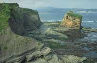
Except for the stretch of coast that goes from the mouth of Atturri, the sandy coast of Landeta, to the first cliffs of Biarritz, the most remarkable feature of the Basque coast is that it is formed by cliffs of different ages and compositions. On the bases of these cliffs many beaches open to the sea and only cut in the foothills of the rivers that create at the end of them.
Addressing the study of the secrets kept by our cliffs will help us not only to know when and how Euskal Herria was formed, but also to understand the geological and biological phenomena that continue to occur on the coast. You will not deny me, therefore, that the subject is interesting.
Formation of cliffs
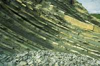
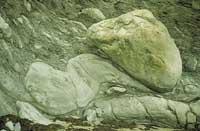
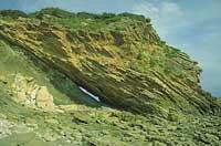
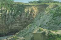
The first time he approaches the cliffs of Euskal Herria will undoubtedly be the initial fascination. However, you will soon realize that most of the cliffs, like the pages of the books, have a structure of strata. You will also see that these strata have a stone structure called “FLYSCH”, created by the alternating hard material/soft material. The hard materials of flysch are usually sandstone or calcareous, while soft materials are clay or marl.
Although the origin of these structures has had to pass many years and it has had to discard numerous hypotheses, nowadays it is quite assumed the origin of these rocky structures that are observed in our coast and in general in different places of the Basque Country.
We must go back in time to understand this phenomenon and return to the Cretaceous, which lasted from 145 million years to 65 million years. At this time, the current Sierra Pirenaica and the Basque Country were the oceanic basin that separated the Iberian peninsula from the Eurasia plate. The materials eroded by the rivers of the time were stored in the marine platform and slope of the oceanic basin. When these sediments reached a high consistency, they slid through the canyons of the slope and produced rock and submarine sludge known as turbidity currents.
Due to the currents of turbidity, turbidites and hemipelagites (sediments that move in the currents of turbidity) settled on the seabed. The rate of implantation depended on the types of sediments: when hanging the lighter materials, the heavier materials (turbidites) were placed first and, much more slowly, the lighter ones (hemipelagites) over the previous ones.
Consequently, the sediments of the seabed were turbidite and hemipelagite in alternate layers. The origin of the present Flysch structures would, therefore, be these layers.
The prestigious geologist Bouma explained that each sequence of Flysch's hard material/soft material can be considered as a layer, as it is the result of a single turbidity current. According to Bouma, in each layer of hard/soft material five differences can be distinguished (see upper left image).
To all these phenomena we must add the so-called geological “sinking”, that is, the fall of the marine bottom. This is the only way to understand these large sediment deposits.
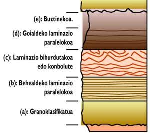
In favor of this theory numerous tests have been presented and undoubtedly the most reliable are paleontological. For example, while in flysch sandstones there are many marine microfossils in shallow waters, the intercalate clays present a large amount of pelagic foraminifers of great depth. All these data indicate that after the turbidity currents the establishment of the first ones was faster and the establishment of the second ones slower.
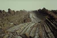
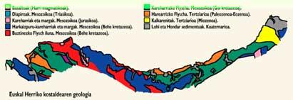
However, it must be said that not all the cliffs of the Basque Country have the Flysch structure, but other geological structures such as dolmens limestones can also be observed. The rest of structures will be discussed later.
Uprising of the Pyrenees
These phenomena occurred during the stay of the Basque Country under the sea, but with the entrance in the Tertiary, which lasted for 65 million years until 2 million years, in the east, the rising of the Pyrenees started in the Cretaceous reached its western part, which also began to impose itself above the level of the sea.
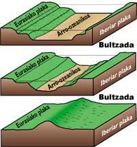
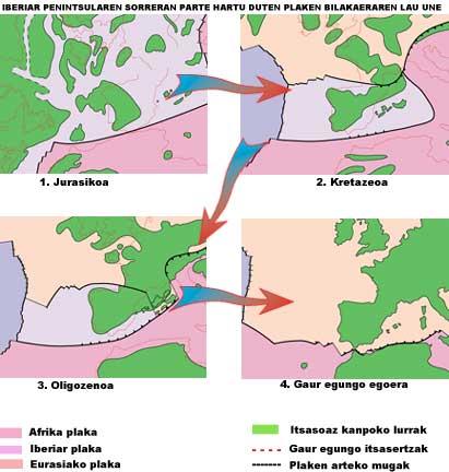
The reason for the rise of the Pyrenees should be sought in the movement of the Iberian plate. Taking into account the theory of plate tectonics, in the triassic period, the current Iberian peninsula was united to the plate of Eurasia and in the south to the African plate from present-day Brittany. During the Jurassic, the African plate began to move east and with it, moving away from Brittany, carried the Iberian plate. This process continued until the Upper Cretaceous, when the opposite phenomenon occurred: The African plate pushed the Iberian against that of Eurasia and as a result of this impulse came the raising of the Pyrenees.
As a result, what was the sea for a long time became dry and a new coast appeared, leaving the erosive agents with stones that had been submerged until then.
As a result of this survey, the sediment layers were broken in various zones, with faults appearing. The failures are of vital importance to understand the current structure of the Basque coast, since these breaks cause the large rock compartments to fall and the strong frictions that occur in this step greatly increase the temperature of the stones. These high temperatures provoke great changes in the rocks and the appearance of more erosionable tectonized regions for erosive agents.Erosion of the new coast
Once the Pyrenees and the whole Basque Country were lifted, the geological phenomena in this region turned 180 degrees, since until then the area of submarine sedimentation became coast, beginning to receive the influence of the erosive agents.
However, it must be taken into account that since the rising of the Pyrenees the level of the sea has not remained the same, since the glaciations of the Quaternary have influenced notably on the coast line. During the glaciations, large amounts of water were frozen in the glaciers, bringing the sea level back. In interglacial times, however, the ice melted and the sea level rose.
Several studies have shown that in glacial times our coast was thirteen kilometers ahead of the current one, with a water level between 100 and 120 meters below the current one. This phenomenon has directly influenced the physiognomy of our coast, which has caused the formation of the current coastal channels and rías.
According to geologists, in the last 2 million years there have been five glaciations and glaciations. From the oldest, the names given to glaciations are: Donau, Günz, Mindel, Riss and Würm.
Today we can say that we are in the glacial period after the glaciation of Würm. Since the beginning of this glacial period, erosive agents have constantly attacked the new coast.
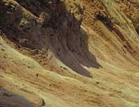
There are many erosive agents (waves, wind, rain, etc.) The erosion of the waves is the one that most abruptly produces in the cliffs. Due to the action of the drawer, especially during the days of storm, the stones and rocks fall on the bases of the cliffs, where great holes open with the passage of time. These holes cause that when the bases are not able to withstand the cliff, the cliff falls and the coast backs. In addition, in the falls more stones and rocks accumulate at the base of the new cliff; as the phenomenon increases, the coast is slowly but continuously retracted.
Witnesses of this decline are the valleys that, since the erosion of the sea is faster than that of the river, hang the end of the streams in the form of a cascade, as well as the cracks denominated platforms of abrasion that are exposed in the bases of the cliffs during the bajamares. As we will see later, these abrasion platforms constitute an “intertidal ecosystem” so important from the point of view of biodiversity, productivity and originality.
Some of the erosive agents that affect this abrasion platform with life in this ecosystem are molluscs punching lamelibrankios that pierce these stones to build the cabin, especially of the genus Lithodoma, which initiate an important erosive phase.
In fact, when these molluscs die, the holes that are made are empty and due to the action of the waves, the small sands and stones that enter it begin to increase the holes. Thanks to this, the largest rocks find access and, finally, the holes offer the necessary living conditions for other species of living beings of this ecosystem. In other words, these holes are natural coastal aquariums, and their influence will become evident throughout the platform.
Differential erosion
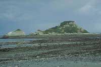
Those who know the coast of the Basque Country know that this phenomenon does not occur in all places at the same rate, since in our coast abound the geomorphological elements less eroded compared to the surrounding cliffs (cabos of Ogoño, Matxitxako or Higer; islands of Billano, Izaro or Urgul) and others more eroded (La Concha, etc.
The explanation of these phenomena is the differential erosion of the coast. In fact, coastal erosive agents do not affect the same rhythm in all geological strata of the cliffs. For different reasons, the erosion of some materials is easier and, therefore, the quickest delay on the coast leads to the creation of bays, rías and geomorphological elements of this type. However, other materials are difficult to erode by erosive agents, so islands, ends and geomorphological elements of this type appear.
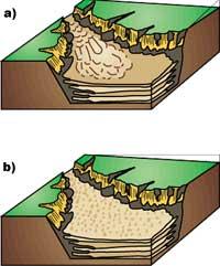
Three are the factors that influence differential erosion. On the one hand, we have the great erosion of the tectonized regions. As has been said in explaining the uprising of the Pyrenees, the failures generated by the uprising cause large stone compartments to fall from the top of the cliffs. In these falls the friction is very intense and high temperatures are reached. High temperatures cause changes and make local stones more erosive with erosive agents.
On the other hand, the flysch structure itself directly influences differential erosion. In areas with layers of thick, soft hard material (sandstone or limestone) (clay or marl) thin, the drawer wear will be less. However, regions with strata of fine and thick hard material of soft material are more mobile and the coast is easier to go back. And finally, the appearance of special rock structures DIAPIRO in some aspects of our coast also influences. The diapiros are plastic rocks formed by marbles, clays and, often, magmatic stones called Triassic ophites that bloom through the top stones.
Its most remarkable feature is the high mobility, so in the diapiros areas are opened bays or rías (Urdaibai, Bakio, Zarautz, Mutriku, etc. ).
The coast we know today is a consequence of all the aforementioned factors and processes. Now, let us return to the present and study our cliffs more thoroughly.
Stretches of cliffs
Although there are great differences between the cliffs, in most cases two areas can be distinguished:
- Abrasion platform: as mentioned above, the pull force is concentrated at the base of the cliffs, making larger and larger holes. When the dimensions of these holes impede the maintenance of the cliff, it emerges and at its base develops an abrasion platform dependent on marine tides, silent witness of the cliffs of the past.
- Rocky cliff: it is a rocky cliff that rises perpendicularly to the abrasion platform. In it you can distinguish three differentiated zones: the first is the nearest cliff to the sea, which usually presents slopes of great inclination and supports the most violent effect of the tyre; the second, located on the last and with a soft slope of slopes and cornices, and the third upper part of the cliff. In the latter, the slope of the cliff and the influence of the sea are insignificant and the wind is the factor that contributes the most.
Buletina
Bidali zure helbide elektronikoa eta jaso asteroko buletina zure sarrera-ontzian


