Animals guarded from space
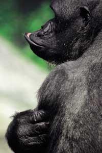
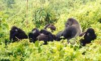
In 1994, the War of Rwanda and the massacres that took place in it filled all the informatives of an impressive image. Poverty and disaster in Rwanda are evident, but without forgetting all this, today we will talk about something more: The gorillas that inhabit the mountains of Rwanda. In fact, the organization Dian Fossey, dedicated to the protection of gorillas, has launched an ambitious conservation plan for these animals, in which, in addition to the usual techniques, satellites will be used to protect gorillas. Along with the aforementioned organization Dian Fossey, three US entities (the Georgia Institute of Technology, the Atlanta Zoo and NASA) will participate in the project. The modern technology of the telecommunications era is put at the service of endangered species. In this way, biologists will have a new means of habitat conservation and ecosystem management.
The main threat to gorillas is habitat loss. Rwanda has the densest population in all of Africa and there are more than a million people who still do not live. To accommodate all of them, in many cases it is a question of using lands that were formerly wild. The need for more land for agriculture and wood to build houses and cook has led the country to exploit protected natural reserves. In addition, the proximity of the human being makes it possible to transport diseases to the mountains of Virunga, the fragile habitat of gorillas. In recent years, in addition, many gorilla have been killed: sometimes to be able to eat, sometimes by the simple desire to die and sometimes by accident.
Digital technology digital technology
Rwanda, the Democratic Republic of the Congo and the primates colony of the lands of Uganda are currently about 600 gorillas. They are the only survivors in the world and various associations, including the Dian Fossey International Organization, are making a great effort to protect them. Due to safety issues, researchers have been far from the gorillas in recent times, but have returned to work.
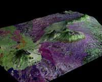
As we have said, these researchers have also begun to look from space. The first task will be to fix the state of animals and their environment. For this purpose, the geographical information collected by satellites, aerial images made by special cameras and demographic data settled on the ground will be used. In this way, they will calculate the amount of gorilla that can accommodate the Virunga mountains and lay the basis against the loss of habitat that can occur in the future. The capacity of the region to maintain gorillas can be known, for example, by measuring the amount of food it contains, and in passing, useful information will be obtained for the management of natural parks.
New technologies will help to understand the complex interactions between gorillas and the medium, as why they prefer some areas of the forest or why they never sink into others. In fact, researchers consider that a better understanding of the characteristics of land, vegetation, and water resources can answer the above questions.
Data collection systems GIS (geographical satellite information) and GPS (Global Positioning System) will be used jointly. The images collected can be seen in three dimensions and have made a virtual replica of the animal environment.
The biologists have in their hands very powerful tools that so far have not been applied to the conservation of species. Subsequently, the data will be spread through wireless communication systems and finally, thanks to the Internet, all this information will arrive in an instant to scientists or biologists from anywhere in the world.
Outside of Gorilas
The program began in 1992, but in this spring it has received a great boost, since they have started to use an air chamber capable of separating the plants individually. The camera was developed by a company from Idaho and National Geographic participated in a television program. It will now be used to protect gorillas. NASA has also offered its support to the program through its satellites. Globalization, therefore, has also reached people who are dedicated to the conservation of animals, instruments that have overcome physical borders between countries and continents.
The project will not be limited only to the protection of gorillas, since animal welfare cannot be separated from the welfare of the people. Therefore, they intend to develop in Rwanda part of the elements of all this technology. They are building scientific and technical infrastructures and training people from their universities. In this way, the university of Rwanda will be able to carry out international collaborations.
This technology will focus on agriculture, the social sciences and, in general, on scientific applications and can be a valuable development planning tool. In addition, remote sensing can be used to represent the national map, develop communication networks or search for minerals. However, the care of gorillas can also directly benefit Rwanda, since up to 1994 it attracted many tourists. Finally, they want to make remote sensing and extend to everyone the centers that will use the GIS system to protect other non-fat animals.
Anywhere else
The panda bears in China or the elephants of Zaire face similar risks to those of the gorillas of Rwanda. In fact, in the four corners of the world, animals are threatened by the destruction or transformation of their habitat.
The habitat and vegetation will be different here and there, but the elements of the model of destruction are the same. Therefore, it has been proposed to expand the technology to be applied in Rwanda to other countries.

The greater participation of organizations in this type of projects would allow to distribute the technology and reduce costs. People who work on the ground will receive all the information, can receive the help of an expert thousands of kilometers in a short space of time, and research can spread easily and economically.
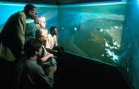
Before at least, the idea seems good. In addition, the images that have gathered in Rwanda have begun to be used for education. In Atlanta, a virtual replica of the Virunga mountains has been made, in which one can see first-hand how man affects the environment. Instead of looking at the gorillas in the cage, the virtual program allows you to live with them on the mountain. The viewer will live if the relationships between family members, the hierarchy, the duties of the day, the struggle and the dangers were real. However, to see if the gorillas of the future (or any other animal) we find them not only in the virtual world, but also in the mountain.
Published in the supplement Natura de Gara
Buletina
Bidali zure helbide elektronikoa eta jaso asteroko buletina zure sarrera-ontzian