NASA in Antarctica
To learn about the evolution of the Antarctic ice sheet, NASA has been developing the IceBridge research project for years.
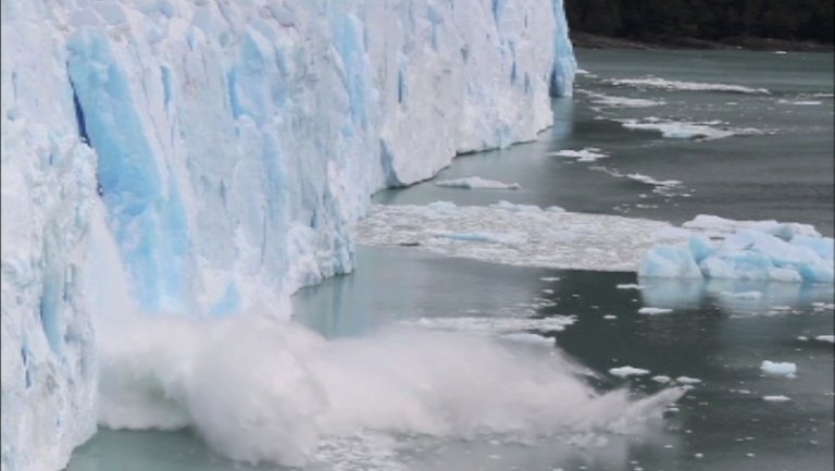
Ice sheets, glaciers, sea ice... These are the images that come to us from the Antarctic continent through the many inspection missions that are carried out in this territory.
NASA’s IceBridge operation, for example, has completed seven scientific missions this year. A DC-8, organized with measuring instruments, has carried out long-term flights in the area of Punta Arenas, Chile. seventeen scientists have participated in the campaign to collect data on the state of ice in Antarctica.
MICHAEL STUDINGER; nasa: This is the 4th year that we will return to Antarctica with DC-8. We’ve analyzed data from previous flights and missions and found that ice sheets are rapidly thinning, such as in the Pine Island Glacier. This thinning is accelerating and expanding indoors, so it is essential that we take care of it and return it every year to collect the data that will feed the computer models that we need to be able to make future predictions.
On a flight, a huge fissure was discovered in the Pine Island Glacier. The satellite images show the huge chunk of ice that is about to be released, which could create an iceberg that would be the size of New York City.
KELLY BRUNT; nasa: IceBridge did a great job analyzing the gap and providing a broad view of its dynamics. The ice mix there is very interesting.
The fissure was spotted unexpectedly last year. It would be amazing to be able to come back and see its development or make a new inspection associated with a frontal ice fall.
Normally, the mountains of the Antarctic Peninsula are surrounded by fog but today the view is clear. As it descends, vast areas of marine ice of varying shapes and thicknesses are observed. This is a region of shrubs with sea ice and icebergs. The color and structure of the ice allow age and thickness to be classified.
This ice has the same thickness as the one that has passed and lasted the summer.
The darker, more gray ice is recent and will be about 10 centimeters long. The white ice that has covered the snow is again more than 30 centimeters.
The ice in the lower half is so soft that it will only take a few hours. It is a fragile ice, granular, like a muddy drink and has been created by the dynamics of water turbulence.
Operation IceBridge has returned to the Pine Island Glacier twice in 2012.
On his first trip, he flew over the entire region. After completing this campaign, scientists were able to compare the new study with previous measurements to better document the rapid and widespread changes in the region over time.
During the second expedition, IceBridge flew through the branches of unmeasured glaciers. He studied the fundamentals to acquire data that will help to measure future changes.
KELLY BRUNT; nasa: The greatest contribution that the sea has received from the Antarctic source to raise the level has been the change we see in this region. Not only on Pine Island, but also on the nearby Thwaites Glacier.
The huge gap that has been discovered has been a phenomenon that causes curiosity and a really important event.
As a result of the recent flights of Operation IceBridge, the team has very good images of the crack that the snow has filled and information about its development. Soon a new iceberg will be created. It’s hard to know when it will happen, but the conditions are right for it.
KELLY BRUNT; nasa: The sea ice acts as a buffer for the bottom sea and protects the front of the ice shelves. The absence of sea ice in front of the Pine Island Glacier would mean that he is preparing to release it.
IceBridge will bring data from this campaign that will be used to monitor the condition of Antarctic ice sheets. The satellites will continue to observe the crack of the Pine Island Glacier as the melting continues.
Buletina
Bidali zure helbide elektronikoa eta jaso asteroko buletina zure sarrera-ontzian