War as seen from archaeology
at the end of August and in the first days of September 1937, one of the most terrible battles of the Spanish Civil War took place in these lands of Aragon.
The situation of the Republicans on the northern front was difficult and, in some way, to reverse it, the Republicans prepared an offensive in Aragon. The attack was aimed at taking Zaragoza from different points.
Thousands of pro-Franco soldiers gathered in Belchit to fight the attack. In the village itself and its surroundings, cement and iron fortresses were built, machine gun nests, trenches, observation points, etc.
The first fighting in the Belchite area began on August 24, and by September 6, Belchite was in the hands of Republican troops. But seven months later, Franco’s supporters took him back by force.
After the end of the war, Franco decided not to rebuild the old town, “as an exponent of the cruelty of the Reds” in his own words. Instead, he ordered the construction of the new Belchite with the labor of Republican prisoners of war.
These lands, which were once filled with military personnel, are today a meeting place for archaeologists. On the initiative of the International Brigades and coordinated by the CSIC, the International Brigades Project is underway with the aim of approaching this war landscape from an archaeological point of view. Among them is the UPV/EHU Research Group on Built Heritage.
At the Battle of Belchit this area was important, wasn't it?
After all, this was the starting point of the Battle of Belchit in its early days. According to the official Francoist version, a soldier committed treason, and he surrendered without firing a shot. But archaeologically, we know that fighting took place here.
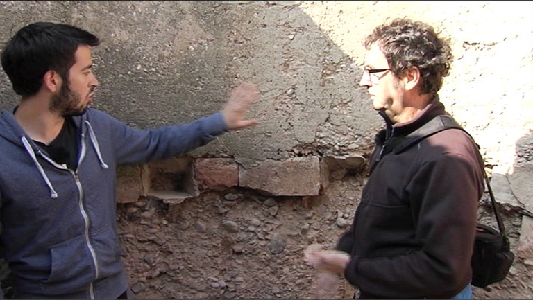
We see a special building here. What is it?
This is a location for the installation of machine guns, made of cement, made by Franco’s military engineers. It was about being unmissable, as you can see we have a 360-degree view.
What if it's coming down here?
Yes, of course, we'll come down if you want. As the site looks, it is a very strong fortress, made of cement.
Make a complete tour.
Yeah, it's a complete twist. These are the following supports to place the legs of the machine gun, then here we have the trunks, with a fairly wide view, to shoot. Here we see that there is a platform and a passage next to it. We have to imagine that the man who drives the machine gun is up here, and next to him is the assistant passing the ammunition.
The following is a trench line that emerges from the position of the machine gun.
They'd be down here, wouldn't they?
Yes, because here with the shots and there was danger! It's very narrow, even very high. And its main function is to communicate with other points. And this is a trigger point. It's coming out of the trench!
The trenches form very long lines that surround the entire hill of El Saso, since everything, like a cheese, is perforated. This shelter is proof of that.
You have done all this by hand.
All by hand, for several days, and with tools, several colleagues. It’s worth it, in the end it’s a very important structure and a very nice example of military engineering. We've got him up here, to go out there, to breathe a little tunnel, somehow.
For the ventilation.
At least there's dust. From here to where?
We can go from here to Paridera, another significant place. At the end of the day, the soldiers’ home, of which we have found many traces: how was their food, we can even imagine a little sleep... and in general here the lands are quite displaced by the works, and now some colleagues are geo-referencing everything.
We have captured the topographers of the research team in the work, because one of the objectives of the project is to produce empirical knowledge that will account for the ruins of war and post-war. Maps that will represent the site in this case.
The cut is: Assisted by Teresa Mañana
We are co-locating a topographic database of bases with a differential correction GPS, which is providing us with support points for this campaign and in the next few years, taking geo-graphic data with a different correction. These data come from the constellation of satelites that rode us. They are captured by this antenna that is above, and with another support base that we have here in the environment, we are creating global geographic positions with high precision.
Leaving El Saso, archaeologists head to the hill of El Mojón del Lobo. it is a hill with a height of 630 meters, the highest in the area. Here the Republicans built a four-edged tunnel to place artillery pieces and bomb Belchite.
The task of obtaining three-dimensional representations will be carried out today. A 3D laser scanner will be used for this. The laser rotates 360 degrees, the laser rays measure the distance to the objects, and the addition of the angle of rotation results in images composed of millions of points.
Bringing all this data to the computer and using special software, the experts build the most realistic representations of the environment.
In this way, the elements that are being recorded at the archaeological level can be represented, and this geographic information will be comparable to what can be taken in the future.
Pieces of glass and ceramics, various coins, cans of preserves, the ammunition used on both sides make up the archaeological treasure collected in the works of Belchit. But also more curious things that should theoretically be destroyed by the passage of time and the fluctuations of time: a canteen, a pair of uniforms, the remains of a newspaper written in Catalan, etc.
With the end of the excavation campaign, the time has come for the experts to study all these ruins, to recover what is possible. In fact, these remains testify to the war, the way to make an archaeological reading of the facts.
Buletina
Bidali zure helbide elektronikoa eta jaso asteroko buletina zure sarrera-ontzian