technology of more than 2000 meters
Geko Navsat and Tecnalia have developed a system called Safe Mountain to manage risks on the route to Aneto.
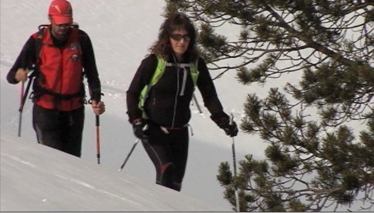
We are located on the Benasque Plateau in Huesca. From here the ascent to Aneto, the highest peak of the Pyrenees, starts. aneto has 3,404 meters. A risk management system for testing, called Safe Mountain, has been installed on the route. The mountaineers Monica Mena and Carlos Llorente belong to the team of experts dedicated to the management and evaluation of this system. They will climb to the mountain refuge of La Renclusa and will update the system along the way.
CARLOS LLORENTE; mountain guide: We take care of the information entry and we see the problems of the road. We manage the user menu. Let the problems they pose be real, like the ones you will find in the media. Unlike other applications that can be found on the Internet, behind this is a team of professional guides who strive to make the information as real as possible. As for our work, every time we make a climb we note the problems: a point where we have seen the avalanche, or any event that is important for the mountaineer who wants to make this route.
The Safe Mountain project won the European Galileo Master Satellite Navigation competition representing Gipuzkoa. The original idea of the project is that of a small company, Geko Navsat; they develop technical solutions based on GPS. Based on the winning idea, the Tecnalia research centre was responsible for the technical and technological development of the platform, which has been installed on the way to Aneto for testing, in the heart of the Pyrenees.
JESUS MARCOS; tecnalia: Tecnalia has designed the architecture of software: communication systems, servers... the technical-technological part of development. Safe Mountain is based on three elements: server, beacons and mobiles.
The user must upload the program from the Safe Mountain server. Depending on your level of mountaineer, the program will propose the most appropriate routes, taking into account the conditions of the state of the route. In addition, you will also be advised of the equipment you will need and the measures to be taken.
JESUS MARCOS; Tecnalia: We are in the idea of the Internet of Things. The devices talk to us, they give us information in real time. That’s a gift: the phone or another device says “don’t go there because there are problems; go this other way”, “you have this mountain refuge to choose from”
CARLOS LLORENTE: Have you seen the snowfall?
MONICA MENA: Ah, yes, there! It's a good jump. The sun is strong in the south.
CARLOS LLORENTE: Oh, yeah, yeah. I'll take a picture of him. In the South, the risk is greater. All right, all right. Well, let's keep going.
You can find a lot of information on the Internet, but you need to know how to filter it. Here we take care of filtering the data so that people do not have the wrong data when they start climbing, about the state of the snow or, in summer, when there is no snow, about the state of the glacier, which can be even more dangerous to climb to Aneto.
CARLOS LLORENTE: There's plenty of snow, isn't there?
MONICA MENA: Two meters and figs.
CARLOS LLORENTE: What is this, two meters and forty?
MONICA MENA: Yes, two meters and forty centimeters.
The beacons installed on the road are equipped with satellite communications and include Wi-Fi and Bluetooth. It detects registered users as they pass, and mountaineers can report events, thus collecting information in real time.
MONICA MENA: .I'm also updating in the app
The beacons and the server that receives the information are both designed and assembled at the Tecnalia research center.
JESUS MARCOS; Tecnalia: It has an architecture that allows multiple communication with different systems: wifi, bluetooth, Galileo-GPS. That is, the interconnection of the three systems on a server is important; the multilaterality of the system in the software architecture, this integration was a problem, a challenge.
A second challenge is to have beacons with high autonomy and to remain in very harsh conditions, i.e. in rain, snow... And the third challenge is to have a system that is cheap and easy to implement.
In addition to ensuring communication on the mountain, the beacons receive information about the location of the mountaineers along the route. In this way, it facilitates the work of rescue teams in the event of an emergency.
CARLOS LLORENTE: It has many advantages for the user. The search is aided, for example, by the crossing of two people with the application installed, a point that is recorded. It also helps rescue teams to know what level of mountaineer they are looking for, and in the app the user fills in a section about their experience.
After receiving incidences during the tour, Monika and Carlos arrive at the refuge of La Renclusa.
GREETINGS AND GREETINGS
In the shelter is one of the beacons that are placed along the route.
It has been in operation for several months and has been found to be effective in winter and over two thousand meters.
IÑIGO ARIZAGA; Tecnalia: Tecnalia’s vision is one of our projects in the Safe Mountain electronic services concept group. It’s strategic for us. Everything around us is getting smarter and smarter. Connectivity has also been included in things we didn’t expect, intelligence... we call this “smartization” and it is being talked about more and more. Smartgrids, smartphones, smarcity... smartphones. And that intelligence for what? The answer is to make life easier or, why not, to brighten it.
JESUS MARCOS; Tecnalia: A communication is created. This system goes that way. Overcome the simple geolocation and location and information in real time in this mountain area. This is the way in which the Internet of things goes or the way in which things communicate.
With the aim of developing intelligent environments, Tecnalia hopes that over time Safe Mountain will be useful in nature parks, ski resorts or natural environments as well as in cities.
Buletina
Bidali zure helbide elektronikoa eta jaso asteroko buletina zure sarrera-ontzian