When the waters leave the channel

This control system was designed by the Department of Hydraulic Works of the Provincial Council of Gipuzkoa twelve years ago taking into account the characteristics of Gipuzkoa. On the one hand, the rivers are very short and overflowing, and on the other hand, the amount of rain that each basin receives is very different. Thus, when heavy rains occur, rivers become very dangerous due to the high probability of overflow. Given this risk, this Provincial Council considered it necessary to establish a system that would control the flow of rivers at all times.
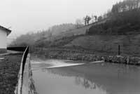
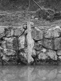
In these areas of flow collection an artificial channeling is carried out in a specific section of the river so that in this section the flow of the river has the same level and has a specific reference for its measurement. On the other hand, on this section are placed two cables that cross the river, each of which has a sensor that keeps all the ups and downs of the flow. These data through microwaves arrive every ten minutes to the Department of Public Works of the Basque Government, Diputación Foral and SOS Deiak. In this way, they can control the flow of the river at all times and if there is a risk of overflow, take the necessary measures immediately. Although data is constantly received, these connections are expected to multiply in the short term, as it is about ensuring that in crisis situations their operation will not fail.
According to the provincial of Hydraulic Works, Jorge Letamendia, "this system informs us at all times of the height of our rivers and therefore of the state of our basins. These data, together with data from torrential rains, allow us to make diagnoses of what may occur and, if deemed appropriate, take appropriate measures." Experience has shown that it is possible to predict what will happen below our higher basins. "However, we must bear in mind that our basins are very short and steep. Therefore, what happens in our rivers is very fast. In the Ebro basin, if heavy rains occur, there are two days before knowing what will happen 100 or 200 kilometers below. It is not possible to do so in Gipuzkoa because we have no room."
More complete system

The flow collection network project was carried out in 1987, with a budget of 707 million pesetas (28 million pounds). Although the installation of 16 sites was initially planned, it has finally opted to locate a new recreation area in the network, so the budget will amount to 800 million pesetas (32 million pounds). The Añarbe Community and the Gipuzkoa Water Consortium have completed three other reservoirs, all smaller. This embellishment system is expected to be completed this year with two other areas: One of them will be built on the Oria River, at the height of Lasarte-Oria, with a budget of 80 million pesetas (3.2 million pounds). The second berth area will be at the end of the Añarbe reservoir and has a budget of 52 million pesetas (2 million pounds).
According to the technicians of the Council, this network is the best in the State and the most advanced in Europe: "Experts in the field insist on the lack of data. The small territory of Gipuzkoa, for its part, makes the number of recreational areas very high, since here we have as many recreational areas as the Ebro basin has. In addition, the Gipuzkoan basins, in addition to being short, have a very variable rainfall. The average rainfall of last year in the Urumea River was 2,500 mm per m2 and in the Urola of 1,329 mm. These data highlight the differences between our basins and rivers and, therefore, in each basin we have two or three areas of weeding to have more information and better control our rivers."
Water quality analysis

In the most complete stations, as already mentioned, in addition to flow control, the quality of the waters is analyzed. According to Letamendia, this study offers the possibility of ecological studies in watershed ecosystems and, consequently, provides very useful information for the steps to take to improve water quality. "In this way, maintaining the ecological quality of the river in the best possible conditions, we put in place roads for the best functioning of the purification system". In addition to quality control at these stations, another 59 mobile points are made. As for the state of the rivers, according to the foral memory 1997-98, the quality of the waters has improved in recent years. The Bidasoa, Oiartzun and Urumea rivers have achieved an acceptable quality, improving the situation of the Oria and implementing the entire sanitation system in the Urola. However, the biggest problems occur in the upper basins of the Oria and Urola and throughout the Deba River.
Floods
Floods are not always the same. According to experts, at least two types of floods must be distinguished:

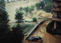
Some occur in large areas with prolonged heavy rains. In these cases the basin receives a large amount of water, which reaches the flow and which at a certain time overflows. The floods that occurred in 1983 were of this type and are usually the most dangerous. These floods can be foreseeable by areas of frost, as the sensors collect the increase in the flow of the river. This information has served to inform society and take appropriate action.
Secondary flooding occurs when heavy rains fall into a small basin (5-10 km2). In these cases the time that passes from the fall of the rain until it reaches the channel is very short and suddenly the flood occurs. The stations cannot act against this type of flood, as it occurs before it reaches the flow. This is the case of the floods of June 1, 1997.
Buletina
Bidali zure helbide elektronikoa eta jaso asteroko buletina zure sarrera-ontzian


