Raúl Ibáñez Torres: "Geometry offers new tools to better represent maps"
But that is a pessimistic vision. But I have a positive vision. Geometry offers new tools for a better representation of maps. I don't think it's a source of frustration. It is true that geometry says that one cannot make a perfect map of Earth -- of a sphere, in short --. But people don't think what that means. This means that a map must maintain the characteristics that interest us. What do we use on a map? Distances, shorter paths, surfaces, directions, angles, etc. We want the maps to keep all of them. It is a metric problem, of measuring. We want to bring the metric characteristics of a sphere to a plane, which is what geometry considers impossible.
XVIII. In the twentieth century Euler showed it with a nice and simple test. If I catch a ball and break it in half, and try to turn an average flat, I will fold it or break it. Or vice versa, if I try to stick a stamp on the skin of an orange, the seal will be ruined. This shows that it is impossible to make a perfect map. What if it is impossible, what? We have to make maps that keep the most important features.
The map of Mercator took great importance in the time of the great trips, since it kept the directions of the routes, something essential in the navigation. That is why it has been so important for centuries. For this reason and for another reason: in the territories near the equator (classic version) the map presents a very low distortion. Therefore, in maps of very small territories, the projection is very important.
Specifically, for the realization of maps of Euskadi or small territories, the projection called UTM is used. Many of those who work in cartography do not know what it means, but ask the computer program to use UTM. UTM means Universal Transverse Mercator, universal cross projection of Mercator. It is an adapted projection of Mercator.
On other occasions, however -- when we make murals or represent scientific questions, or for the distribution of the languages of the world, or for various maps of dissemination, or for didactic maps -- we need maps that support surfaces or distort surfaces very little. These maps inform us of the territories and what is in them. There are many maps of the same surface, like that of Lambert.
For example, those who hold the shortest paths. In them the central projection is used. It is a very used projection in maritime and air navigation. It is important to use geometry to select the most appropriate maps. That is what has been done in history. A good example is that of the first pilot who crossed the Atlantic by plane and only in 1927, Charles Lindberg. In order to make the flight he had to know where to go. Projection of Mercator to maintain the direction that interested him. But with this projection he had to deviate a lot and was forced to travel a long way. That is why he used Mercator together with another projection, which kept the roads.
The minimum distortion is in Ecuador. But the UTM projection is used by replacing the equator with a meridian and parallel, depending on the territory you want to represent on the map. Near this point, the projection is very good. That is why the UTM is used. In satellite images, for example, the UTM projection adapts to the trajectory of the satellite.
By the way, many satellite images are not photographs. They are the data bars, which are led to a geometric projection and which constitute common maps. Then add colors to give it a realistic look.
The maps have not changed much, but they do use maps, since today we can know where we are in real time.
It is a very controversial topic and caution. Many people have believed in a false story because they have given a touch of solidarity to the map. But if that is said, people feel attacked.
Peters is a filmmaker, historian, journalist and carries out a thesis on political propaganda. That's important. In 1967 he presented a map, but there was another one like a hundred years earlier. It was performed by a clergyman named James Gall. I don't know if Peters knew it or not, but imagine it didn't. The scientists told him that this map was not new. Science sometimes accepts things that are not new, but only when they have new contributions. The map of Peters had no new contributions.
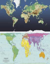
In 1973 he held a press conference in which he presented the map of Mercator as the only alternative to the "racist". He said there were only two maps, that of Mercator and his, and that it is the only map that holds the surfaces. It is not true. There are many maps that support surfaces. For example, the azimutal map of Labert, the sinusoidal map of Sanson-Flamsteed, the conical map of Albers, the map of Eckert, etc.
Those who do not know all this are easily convinced because they are involved with many ideas about the third world: the issue of hunger, colonialism, etc. The media soon positioned themselves in favor of the Peters map and the controversy arose. The cartographers tried to convey the truth, but no one valued them. Subsequently, many religious institutions, the majority Catholic, and many NGOs favored the idea of the map, even UNESCO itself clearly, without addressing the topic from a scientific, geometric and cartographic point of view. It became an icon of solidarity issues. And Peters sold the map.
Many say it has the same thing, which in short is a map that keeps the surfaces. And so, but for many things it is not adequate, because it greatly distorts forms. I think changing one lie for another is not good. It is necessary to make a reasonable reflection. As they did National Geographic, they use many types of maps, but they use the Winkel Tripel projection to show maps of the world. It resists nothing (neither surfaces, nor trajectories, etc. ), but the distortion is very low in all its characteristics. It shows very well the shapes, so it is a good map. A good reflection.
Likewise, the Basque Government and various institutions, including the Elhuyar Foundation, published and distributed the map of Peters in schools. It seemed offensive to me. It could be thought that Peters is of good heart, but if you read your book there are many lies and manipulations (I highly recommend reading, but with a critical attitude). It is worrying.
Buletina
Bidali zure helbide elektronikoa eta jaso asteroko buletina zure sarrera-ontzian