Earth is afraid
These questions have no complete answer for the moment. You can’t predict exactly when, where and how the next one will be, but seismologists know which are the most vulnerable territories and what is the “probability” of earthquakes.
History of the Continents
Formerly, the world had five different continents and only one, called Pangea. Therefore, it can be thought that the solidification of the terrestrial surface occurred around a singular place. All this has been demonstrated not through the new science called plate tectonics, but through the study of the fauna and flora of the primary and previous eras.
At the beginning of secondary school, however, Pangea, meaning “the whole Earth”, formed two parts. The first, called Gondwana, was located in the south and around present-day Africa brought together South America, India, Australia and Antarctica. The other, called Laurasia, was located in the north and brought together North America, Europe and Asia.

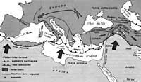
Between northern Laurasia and southern Gondwana was the Tethys Sea. But that sea was changing, because the positions between Laurasia and Gondwana also changed. The ancient Paleo-Tethys became the Neo-Tethys and then the “Mesogeo” sea (“Mesogeo” means land spacing, which means “Mediterranean”). If the history of the Tethys Sea were analyzed in depth, much would be known about the Earth's past.
With the passage of secondary, the two large continents were divided. From Gondwana came South America, Africa, Australia, Antarctica and India, creating an ocean in each of these continental plates. The creation of the Indian Ocean caused India to collide with Tibet to see if the Himalaia mountain range rose. Laurasia was also separated in the sections called North America and Eurasia. North America and Eurasia continue to distance themselves opening the central gap of the Atlantic Ocean.
Current tectonic plates
The earth or tectonic plates on which the continents are found are constantly moving and occasional disasters, such as the Armenian earthquake, are a small sign of these movements. It should not be forgotten that in the last 250 million years the African plate and India are approaching the block called Eurasia, and from this union have risen Himalaya in Asia and Alps in Europe (mountains still booming).
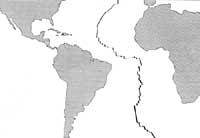
If we analyze all the tectonic plates around the world, they are more similar to the Himalayas and the Alpine phenomenon. North America is moving away from Europe and South America from Africa, for example, and the gap is spreading in the middle of the Atlantic Ocean. But that does not pose a danger to humanity and the shock of the two continents does, because terrible earthquakes occur.
Because the African plate (including Arabia) collides with Eurasia, there is a long line of risk between these continents. The line extends from Gibraltar to Turkey, Armenia, Iran, Afghanistan, Tibet, China and Indonesia through the Mediterranean Sea from the North African Maghreb.
In the Pacific, the peaceful plate is nailed to the Japanese Archipelago and returns to the deep magma through this “subduction”.
When both plates collide with each other, different phenomena can occur. Let us think that two large ice plates are found in the incipient sea. One plate can hit the other, but it can also pass one under the other. In addition, a plate may move by sliding its edge on the other.
This is what has been said for ice plates with tectonic plates. Let us first take the case of the frontal collision. It is an interesting case, but the situation does not last long, since the plate that is moving leaves above or below the other. The passage of the ocean plate under the plate is called “subduction”.
That is what is happening on the line that goes from Gibraltar to the Maghreb. 25 or 30 million years ago, the mountains of Morocco, Algeria and Tunisia were not linked to Africa and formed a chain of islands connected to Europe. However, these islands joined Africa because of the subduction of the marine plate that separated them. In the subdiction, the plate that passes to the bottom leaves “splinters”.
However, the moving plate can protrude over which it is considered immobile and is then called “obduction.” This happens when the Indian plate passes under Tibet.
The other case is that of slipping when beating the two plates. The best known example is the failure of San Andrés in California, United States. This fault is the sliding zone of the peaceful and American plate.
Another option is to remove the plates from each other. Breaking the edges of the plates then forms the “rift”. This is what is happening in West Africa.

Plate displacements generate phenomena at intersections:
fractures and failures. The Earth's surface cannot deform itself and when it is subjected to different forces, fractures occur. An example is the Anatolian fault. There the lands of southern Turkey move away to the Mediterranean, fleeing from Eurasia. The collision between Africa and Eurasia allowed the Caucasus Mountains to rise.
Since then, trans-Caucasian lands have suffered compression efforts, so the earthquake has occurred in both Georgia, Armenia and Azerbaijan. Earthquakes killed by people have been very few. There are also the Ararat and Aragats mountains, ancient volcanoes that remain extinct in the last four thousand years. Outstanding earthquake of the victim. According to the 20th century, on the margin of last year. Last year in Armenia, Spita devastated the city and a couple of months ago 40,000 people died in Iran.
Can earthquakes be predicted?This question only answers at the “probability” level. We know perfectly what are the most vulnerable territories in the world. Thanks to the data obtained throughout history, we know where they occur most frequently and where the most violent occur, and depending on it, where the greatest risk of offspring is found. According to geology, in these regions earthquakes occur due to collisions between surface plates. Scientists know, therefore, why earthquakes occur there and why they do not occur outside of it. However, predicting when the catastrophe will occur is the cider of the other cuba. Geologists know that major earthquakes will take place in Tokyo and San Francisco, but not in what year or century. However, normally a few days before the major earthquakes most of the time are minor. However, when there are small earthquakes, then there are not always large earthquakes. So what to do in those conditions? Should entire cities be emptied whenever there are small earthquakes? To predict major earthquakes, two procedures have been developed: Chinese and Greek. At the time of the Cultural Revolution in China, we studied how to make predictions by adding many small data. Each citizen should inform the President of the Party of their locality about the behavior of chickens, red fish from the kitchen, etc. With all the data from these leaders, conclusions could be drawn. Western scientists did not know these special “Chinese seismographers” until February 4, 1976. That day, a violent 7.3 class earthquake destroyed the city of Haitxeng in Liaoning province. However, there were no deaths because two days before the city emptied. Scientists around the world stayed in the attempt to know the Chinese system, but on July 27, 1976 the system failed. In Txanxi, 700 to 1,000,000 people died from an earthquake of 7.6. So the chickens and fishes did not notice him. Currently there is a “Greek system” or VAN system. P. Varotros, K. Alexopoulos and K. The authors of this method are the Nomikos teachers. According to these seismologists, earthquakes can predict hours or days before, announcing the magnitude and place of the epicenter. From the point of depth, which will be the origin of the earthquake, electric pulses are spread through probably compressed rocks. To predict the earthquake it is necessary to place electrodes on the ground at a distance of ten to ten meters. Depending on the telluric currents collected, it can be predicted that this is an earthquake, but when not. However, it is not possible to fill the entire territory with electrodes, so the VAN method is only used in the intended locations. This system can be said to have been born in 1960. Then, four American radio telescopes recorded six minutes of noise at 18 megaherres. That noise no one knew what originated. However, in 1982, an astronomer realized that the noise occurred six days before the May earthquake in Chile. Then J.W. Mr. Warwie through a laboratory test found that electrical signals were propagated by compression of underground rocks. However, when there is compression of the rocks there are not always earthquakes. So can earthquakes be predicted? There is no complete answer for the moment. Maybe within a few years something else can be said. |
Buletina
Bidali zure helbide elektronikoa eta jaso asteroko buletina zure sarrera-ontzian


