Text written in Basque and translated automatically by Elia without any subsequent editing. SEE ORIGINAL
Maritime transport in Europe
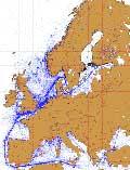
For the first time, the displacements of the European means of maritime transport have been included in a map. ESA's Envisat satellite radar has completed the map with data collected for seven years.
The radar of this satellite has detected for many years the shifts of ships. Now, for the first time, all of this data has been collected and processed for a global view of shipping.
Image courtesy of: Recent searches
Buletina
Bidali zure helbide elektronikoa eta jaso asteroko buletina zure sarrera-ontzian