


Text written in Basque and translated automatically by Elia without any subsequent editing. SEE ORIGINAL
Land displacements of the Italian earthquake
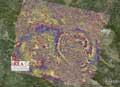
A few days ago there has been an earthquake in the center of Italy, which has shaken the city of L´Aquila. The interferogram collected by the Italian organization IREA-CNR shows how the earth moved during this earthquake (a type of satellite image). The satellite was located at an angle of 23 degrees and received images before and after the earthquake. With each of the color circles they have represented the displacement or deformation of the earth, each of them represents a displacement of 2.8 cm in the direction of the satellite.
Image: Image: IREA-CNR
Buletina
Bidali zure helbide elektronikoa eta jaso asteroko buletina zure sarrera-ontzian


