


Whales fishing whales
A traditional profession of GURE Herria, if we take into account its location, has been to embark and fish. Throughout the centuries, then, they have been present in this activity and, at the same time, our predecessors also dedicated themselves to trade through the sea, a means of fast and cheap transport. With the passage of time, countless actions of our arrantzales and sailors are forgotten.
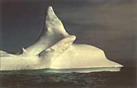
We know that the maritime adventure began very early with our ancestors, and that with it they also adapted shipbuilding and whaling techniques. In fact, XVII. The Basque fishing whales predominated in the nineteenth century compared with other European countries, with the aim of capturing and obtaining benefits to this animal.
It seems that EUBALAENA was the subspecies GLACIALIS or Balaena biscayensis in our shore of the sea XIV. and XV. the one that used to reach the port. At that time, the reduction in the number of whales, or, as is believed, pushed through the Atlantic Ocean and into the cold waters of Newfoundland.
It has had and has another Basque name, which is not a loan, in the coastal towns. About four years ago, it was hot, serious, seroie, seri, etc. from Hondarribia to Bermeo. We found nothing similar on the coast of Lapurdi. In Lekeitio an old fisherman told me: I would be and a whale ‘ok’, and it is evident the house bearing the inscription ZERIA 1575 in Hondarribia, in the neighborhood of Marina. But this name has not been left here alone.
The prestigious Mapuche DESCELIERS, on its American map of 1546, describes a place called B. de Seria on the current coast of the Labrador. They did the same N. North American map by VALLARD in 1547 and F. of 1576. Also on the anonymous Portuguese map attributed to VAZ DOURADO. J. This name also appears in the portulano of maps made by VAZ DEUTECUM in 1594 or approximately in the place indicated by the previous ones. These last three maps appear to be b. de serra and not B. de seria as the first one says, but that is not surprising in our names, surnames, names, etc. If we take into account the deformes that appear today.
A surprising point in this problem is that this type of place names is not mentioned in the document and neither appears in the book of attention of HOYARSABAL nor in that of DETCHEVERRE.
What are the two writers?. We know very little about these writers who left us two magnificent books and we have often forgotten our People, because they have left us the technical books.
It is known that the Basques have been practical and that practicality was the one that probably prompted Captain OIARZABAL to write a squad or a book of guides to navigate. Unfortunately he left us written in French Les voyages aventureux du Capitaine Martin de Hoyarsal, habitant du çubiburu, although the printer did not say that the writer was French, but Basque. Looking for his footprints, in Oiartzun we have been able to verify that currently the hamlet Oiartzabal is still standing. Also in 1579, when he was our captain.
The other book, named by Piarres DETCHEVERRY, was: This libvrv is the Ixasoco Navacioneco, Martin de Hoyarzabalec egiña Francéses. And Piarres Detcheverry, or Dorrec escararat, and later fan. Bordeaux 1677. It clearly says that Detxeberri seems more than his predecessors.
This point has not always been taken into account when analyzing our literary problems, since they have not hesitated. J. Starting with VINSON and then the rest indicates that it is only translation. The equivalence of both books allows us to appreciate that it is not. The analyzed sections have been the Basque coast and that of Terranova. There are similar descriptions (not to say the same), but there are also anecdotes that appear in one and not in the other. Noteworthy is the western case of Newfoundland. Oiarzabal does not mention anything.
It seems that in the west of the current Port aux Basques there was nothing in the time of OIARZABAL, since hardly any names appear in the XVI. In the twentieth century, not in the maps of the Portuguese, nor in the Spanish, nor in the Italians or Dutch. The opposite occurs in the book of DETXEBERRI. Very well, it describes with such precision this western coast, in which it is easy to follow at all costs with a current map.
This means that the Basques knew very well this western coast and, if necessary, their fishing place, with the aim of keeping it hidden to be worth themselves or, however, it was not the XVII. We want to make this coast known until the nineteenth century. There are documents in which it is said that the Basques knew for a long time the secret of Terranova and kept him in silence. It is also known in the XVIII. On this coast of art was called La côte des Basques.
Before we mentioned that the Basques were practical and I mean two words about it. On the one hand, the book left by our two captains, especially the one written by OIARZABAL, has nothing to do with the one he wrote in his day. I have had the opportunity to read the famous Jean ALPHONSE and it is much more accurate our captain, although he also does it in French, like Senct Sebastien, Figuier, etc. This book is sold in the XVIII in La Rochelle.
Few researchers have taken into account the work of OIARZABAL. Another so happens with Detxeberri. His book has hardly been read by anyone and, of course, does not appear in the basic bibliography in research related to marine subjects. Of course, in the case of America they would be indispensable, but it seems that no one knows them. There are exceptions. The researchers PROWSE and HARRISSE knew at the beginning of the century some maps elaborated by DETXEBERRI.
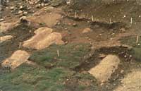
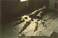
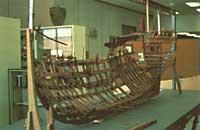
Following the technique, we cannot silence the statements of Canadian researchers. It is known that in 1977, in the current Red Bay of Labrador, a Basque crossbow is under water and research is being carried out in depth, both on the underground and on land. After the study of the ship, it seems that it can be the San Juan, submerged in 1565. According to the researchers, this ship had great advances, equating to those of its time, those that were made in Holland or England.
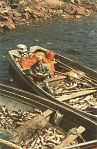
XVI. In the twentieth century, Basque trade seemed to have a lot of strength. On the one hand, it controlled the shipbuilding and, as a consequence of the fishing of whales, they also controlled the market of the fat of the whale or of the saina, since we have said that the problems of fishing were the main ones. What differentiated our whalers from others? The technique devised by the Basques was to go by boat in search of whales and catch with a harpoon subject to a long rope. This was not done by anyone in Europe at that time; XVI and XVII. We mean in centuries.
The whale leaves after his death and is easily transportable to earth. Our fishermen chose special places to carry out the actions described below. They were not on land, on the continent, but on islands. The furnaces were installed in islands as abundant as those before the bay. There the whales are crushed and then cook in a large copper cubes and melt. Then they entered the oak tanks and when the ship was filled they returned home in December or, as the historians of that time say, after selling their goods in many places.
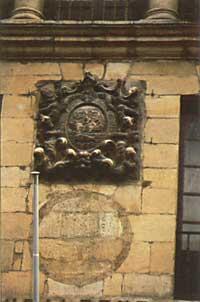
Few things have remained among us after such an important trade. In any case, practically all coastal towns have in their shield or seal the presentation of this action, since almost all have boats (such as Donostia or Zumaia) or whale (such as Biarritz, Hondarribia, Getaria, Bermeo or Lekeitio, to name a few).
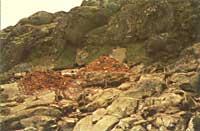
On the other hand, in Canada, to date, several place names, gravestones and submerged containers and furnaces, tiles, ceramics and bodies have been buried.
Our study has been carried out from the linguistic point of view and for this we have taken as base the marine environment books mentioned above and analyzed the maps elaborated then. It is evident that the Basques went to Terranova and returned to work. The displacements on behalf of others and on their own never intended to become their own. They had relations with the premises (sometimes good, others not), but Lope of ISASTI XVII. What was said by the historian of the twentieth century indicates perfectly how those relations were in his day. The Basques taught the Indians and Eskimo (inuit) to say goodbye: How about? – The best cure.
According to researcher HARRISSE, H., the Basques and Canadians had very good relations. Pierre de LANCRE stated in 1613 that:
... les Basques and trafiquoient although les Canadois ne traictient parmy les François en autre langage qu’en celle des Basques.
So, very few things remain in those territories to date. Despite its popularity, it cannot be ignored that the word orein is still oregal until today, and to name it, it has become a common name in the French of Québec. In the place names we have analysed closely, we have seen that one of them has remained a common name, both in its French and English form. Anyone on the coast knows what the bar is (accumulation of sand) and what is the bar, that is, the small bar.
This name, converted in common, appears in two different ways: Barachoix in the territories occupied by the French and Barrasway in the English. In addition to these, and since the two sea books we analyze are so rich (among them can be grouped around 60 names of Basque places), only a few have reached today. We want to put aside the names that refer to us, such as port aux Basques, Echaffaud aux Basques, Ile aux Basques, Biscay Bay, etc. And we will see those that have more relation with the Basque language.
Placentia has remained to date, being able to be like Plentzia in Bizkaia: Burin can be a variant of Buru. DETXEBERRI frequently uses the term head to designate the terrestrial end that advances by the sea.
Vacation ports ports
Today Port au Port is and must take into account the meaning of Oppor, Ophor in different rades, ends, etc. that surround him. It was of San Juan de Luz (coastal therefore), according to Pierre d’URTE, a type of wooden boat. Our Holiday Port would be a port where there were boats. Currently has no explanation Port au port and, if necessary, was French by means of a metaphor.
The Bella Baya, to which Detxeberri alludes, is undoubtedly the Bonnea Bay of today, located in the western center.
Our writer, who gave as a charreco port to his navigational manual, interprets it as Anngurachar in a map made by the same author in 1689, and in the map made by Denis de ROTIS, of Fonachar San Juan de Luz in 1674. It is currently known as Ingornachoix Bay. This place name seems to be treated like others. -bad and bad it seems that the finals have worked as if they were one, since in both cases appears -choix. Here it seems to us that we must see the influence of the French; -oa, -ua, diptongo is like -oir in French.
We would have had a lot to study one by one more than sixty place names, and we will only make reference to the most outstanding. Ferrol çahar, the place that today appears with a clear translation of Old Ferrol has been, however, another name: Etchaire Portu. They say a donostiarra discovered this place and gave it his name. However, this name appears in the minutes of the General Boards of RSBAP 1777. It is very curious what DETXEBERRI says: Etchaire Portu is in Ferrol Caharrerat or Españolec... There is no doubt that these Spaniards were South Basques. If not, it would need a port (with a diptongo) and also the surname Etxaire has no doubts.
Just mention those that appear until the end of the northwest coast of Newfoundland: Amuix, Anton Portu, Buruarrassoa, Miariz. Some of them remind us of the popular charm of Amuits, in Hondarribia, or Biarritz, in Lapurdi.
The descriptions of the places and the abundance of Basque names indicate that the coastal zone was used only by the Basques, so no name appears in letters, maps and portulanos made by European mappers.
Even the Strait of Belle Isle seems that these fishermen were very pleased, by the footprints to date and by the names of the places that appear in the sea books mentioned above. These names indicate very well the action of those sailors: capture whales. That is why we find Balea Portu, Balea Baya, Baleetaco Baya, Labeac... Today we find no remains of names, but many bodies of tiles, ceramics and submerged and buried ships. All this has been investigated for about fourteen years by researchers from Parcs Canada. We hope that the research will take place shortly and that we discover part of our history.
The last problem I want to bring now is that which some mention and which so far no one has taken seriously. Some of the researchers of the beginning of the century spoke of the existence of a Basque group in the elaboration of maps of Newfoundland. This is what scholars PROWSE and HARRISSE say when investigating the problem of Newfoundland.
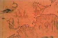
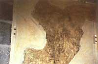
Since then and until 1984 practically no one has taken into account this problem. To us it has seemed very interesting, because it is not easy to find so many tests at a time. On the one hand, the two books of sea and on the other, four maps of Terranova made by Basques: In addition to the book, DETXEBERRI left us two maps (made in Plasentça in 1689), the Denis de ROTIS left us a map (made in San Juan de Luz in 1674) and the map recently acquired by the Canadian National Archives was that of 1713 or that of Sent Ian de Luz. There was, then, the custom of making maps: he also made a house in Donibane. In this activity not only were the Basques. Both for its appearance and location, at least seven similar have been found. Some are anonymous but others have owners, such as CHAVITEAU 1698, DE COURCELLE 1675 or DE COUAGNE 1711.
All this leads to a consideration: the maps made by the Basques were technically of good quality and not in any way. In the above mentioned work Les Portulans is said that the map made by DETXEBERRI is surpassed only by COOK. In relation to this, we might think that in Donibane there was a School of Basque Cartographers, that of Donibane, which has given the largest number of results.
Buletina
Bidali zure helbide elektronikoa eta jaso asteroko buletina zure sarrera-ontzian


