


Uribe Kosta: geological treasure
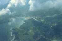
Direct observation, research and observation of rocks and strata exposed by rapid erosion is one of the unbeatable options on the cliffs of the area. But the importance of this region lies not only in the rocks that so well appear, but also in the diversity of geological structures and paleontological richness. Most of the rocks of Uribe Kosta were formed through various sedimentation processes that occurred at the bottom of the sea, sometimes slowly, in which until a few million years ago it covered almost the entire Basque Country. With these sedimentary rocks were interspersed the evaporite rocks, like the plaster, outcropped by the diapirism, and the spectacular cliffs created by the vulcanism of the seabed. The dunes of Gorliz and other areas of the region are a good example of continental sedimentation. However, while erosion is dismantling the production of sedimentation processes over millions of years, we can also analyze and observe the current active sedimentation processes in the estuary of the marine cape of Plentzia and on the beaches of the region.
As has been said, the cliffs and beaches are the best place to observe the geological and paleontological elements, so that the richness of these rocks can be enjoyed by the generations to come without forgetting that they are owed the maximum respect towards them. The geopaleontological interest of Uribe Kosta focuses, on the one hand, on the rocks that make up the region and, on the other, on the examples of tectonic activity, which has shaped and folded the layers. Finally, his interest focuses on the fossils and geochemical elements that conserve these rocks. To all this we must add elements of recent geological activity, such as the dunes and the “raised beaches”, both current and the beaches, the estuary of Plentzia and the karstification zones of the Gatelutxo.
Therefore, Uribe Kosta is rich and spectacular in four fields of earth sciences: sedimentology, paleontology, tectonics and geomorphology. These sections are important separately, being more important that they are grouped in a single region.
Rock formation by Uribe Kosta
Sedimentology and sedimentary structures have much to say about rock formation in this corner of the Basque Country. The oldest rocks on the Biscayan coast are the Triassic evaporites. Among these rocks are plaster and red clays that accumulated about 200 million years ago in an arid continental area. Evaporites, Atxabiribil and Meñakoz emerge. Subsequently, the sea covered most of Euskal Herria and the marine sedimentation took over.
Most of the rocks we see today on the Uribe Coast are the result of the accumulation, compaction and cementation of grains, lumps and sands deposited on the seabed for thousands of years. There is no lack of sedimentary rocks generated by the building beings. Therefore, in this region there are also beautiful limestone reefs. These reefs witness the heat of the sea that covered the area more than 100 million years ago, witnesses of a tropical Basque Country. Most of these reefs were built by rudist bivalves, “chirllas” in the form of calcite or cup.
The Rudists lived in large colonies and formed reefs similar to those we can see today in Australia or in the Bahamas. Beautiful examples of Uribe Kosta reefs can be seen around Gorliz Castle. In addition, in these places not only reefs have been found, but also fossil footprints of dinosaurs in somewhat younger rocks originated in a deltanical environment. The dinosaurs left in the soft bases of the delta of a large river that came from the north their traces of their trajectories, which were later transformed into rocks by time and geological processes. Today, we can observe with great care these petrified footprints located in a dangerous place next to the cape of Villano.
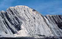
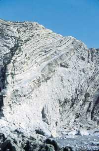
Although the reefs are spectacular, stratification by strata, that is, a structure similar to a giant book, is the most common geological element that occurs in the outcrops in Uribe Kosta. Each page of this book contains thousands of years of geological history of the region. Many of these layers, although not thick, are formed by very compact limestones, which have their origin in the sedimentation of the rain of very fine particles, very slowly deposited in the seabed at 800 and 2,000 meters deep.
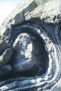
The formation of these rocks, called hemipelagitas, takes thousands of years. But although they are interspersed with hemipelagites, the deposits called turbidites, which form in simple hours or days. These turbidites, unlike the hemipelagite, are generated by the accumulation of stones, sands, coffers and lumps of different sizes dragged by turbidity currents. Turbidites, so to speak, are products of submarine landslides. These embankments descend the continental slope and accumulate both at the foot of the slope and at the seabed.
As it is a very fast process and of great energy, for the first time large lumps are deposited and gradually thinner lumps accumulate on them thus forming the Bouma sequence. For example, in some of the Turbides surrounding Cape Galea you can easily see wonderful examples of the Bouma sequence. In Cape Galea there are also chaotic layers of several meters thick, the megaturbidites. These are formed with large underwater slides that transport in their interior sets of layers even without hardening at all. Most of these layers are fragmented into the downward movement of the slope. Groups of unbroken layers are violently bent. In the megaturbidites we can observe granules of different sizes; the larger ones, the olistolites, are the decametric ones and the smaller the finer clays.
Among the turbiditic episodes were interspersed episodes of millenary tranquility that gave rise to the sedimentation of hemipelagitas. These megaturbidites in the Cape of the Galea were formed about 50 million years ago and can be associated with the formation of the Pyrenees, time in which there was a great instability in the basin and earthquakes caused the fall of the edges of the marine platform on the slope. These megaturbidites are spectacular, even more so because erosion makes them visible in all their freshness.
So far we have talked about sedimentary rocks. For millions of years, these rocks were formed on the seabed through the accumulation of bi-belt and the work of the building beings. But in addition to these rocks, we also have volcanic rocks in Uribe Kosta. Black ball-bearing ships and cushions emerge in Cape Meñakoz, behind the Sopelmar urbanization of Sopelana, and in Armintza. Rocks that reflect the underwater volcanic activity of this region about 100 million years ago.
Biostratigraphy: dinosaurs, ammonites, foraminifers and border K/T
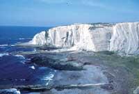
Although sedimentology and petrology in this region are spectacular, stratigraphy is even more attractive to researchers. From the fossils that are preserved in Uribe Kosta, stratigraphy takes on an international character. This science studies the relationships between layers, their ages and their location. Thanks to their stratigraphic, micro and macropaleontological and geochemical works, the beaches of Arrietara and Atxabiribil, in the municipality of Sopelana, have reached a great international prestige.
On the cliffs of these beaches are several cuts of the border between the geological times of Cretaceous and Tertiary. In addition to the Sopelana courts, the Cretaceous/Tertiary boundary appears in Euskal Herria in about twenty places, such as Zumaia, the Concha de San Sebastián, Hendaia, Bidarte, Urko Mendia, Gaskuen and Eguaras. Sopelana and Bidartea are the best in Euskal Herria. These cuts are global and that is why every year several researchers approach him in search of data and samples. Border rocks do not seem to be particularly striking to non-experts, but their micropaleontological and geochemical contents indicate that 65 million years ago there was a profound geological event on our planet. Many scientists of the earth investigate this border in numerous courts around the world to resolve this event. At that time a large number of marine and terrestrial beings died and many species disappeared forever.
Among the creatures then destroyed were the well-known dinosaurs, the ammonites related to the chipirones and inoceramic ones similar to the mussels of a meter in length. At that time Uribe Kosta was immersed in the deep sea, so he did not live dinosaurs, but Ammonites and Inceramids. Their fossils are found in the rocks of the Cretaceous of Uribe Kosta, as in the area of Atxabiribil, but not in the rocks of the Tertiary, which were already completely destroyed.
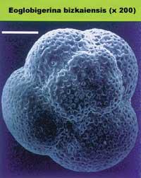
Ammonite and inoceramide fossils are common, but microfossils are still more abundant in their rocks, finding thousands of shells in a gram of rock. Among the microfossils are foraminifers, dinoflagellates, calcareous nannofosil and diatoms. We have abundant and rapidly transformed microfossil species and many species very sensitive to environmental changes. The multiple microfossils constitute the oceanic plankton and are therefore at the base of the trophic chain. Foraminifers are well known among microbeings. These, unicellular type, have calcareous shells less than half a millimetre, in the form of small snails, where when they die they accumulate their shells in deposits of the marine sand that will later become rocks.
Because the rocks of Uribe Kosta are rich in these microfossils, there are already several doctoral theses (X. Orue-Etxebarria and E. Both Apellaniz's thesis, for example, and the research work of the University of the Basque Country and many international scientists have been the objective of the cliffs of the region. Both the remains of native foraminifers and other fossils can give us clues to understand what happened on Earth 65 million years ago. For example, more than 50% of the foraminifers who lived at that time were destroyed, as many have proposed, after a 10-kilometer fireball hit the Earth in the Yucatan area.
On the other hand, in a cut located in the Italian Apennines a high concentration of iridium was found for the first time in a layer of clay that appears in the same limit K/T. While this layer has a thickness of one or two centimeters in the Apennines, in some cuts of Euskal Herria reaches 8 cm. Iridium is an element of the platinum group that appears on the earth's surface at very low concentrations, not in some types of meteorites or comets. In the layer of adjacent clays K/T of the cuts of sopelana there is a very high concentration of iridium, as well as other geochemical remains related to the impact of the fireball such as nickel-plated spinels and soot. The latter is associated with the world fires that would cause the fireball to crash.
Submarine to land: works of tectonics and geomorphology
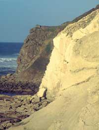
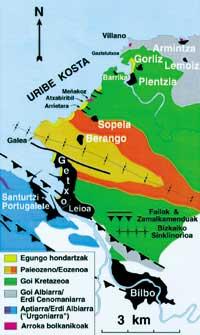
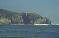
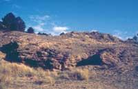
The influence of tectonics throughout Uribe Kosta is very high. Tectonic movements have lifted the coast and, later, the erosion of the sea has carved the cliffs exposing the rocks and structures of the area. As already mentioned, these tectonic agents have raised, tilted, folded and fragmented the strata with spectacular tectonic examples. in the cliffs we can see beautiful folds, sinclinales and anticlinales, as well as failures, large and small. For example, the environment of the cliffs of Barrika is very rich in such structures and is easily accessible for observing structural elements. But the folds we observe directly on it are multiple, but they are of small scale and most of a few meters. However, there is a broader structure: In Cape Galea there is a tectonic structure on a kilometre scale, the Bizkaia Symclinic.
Thus, on the cliffs from Algorta to the cape of the Galea the strata are clearly inclined towards the northeast, while the layers from the Galea to Sopelana look towards the northwest. When these strata join together they form a great “V” in the cape of the Galea: Area of the Sinclinorio of Bizkaia. This structure, crossing the Duranguesado, extends directly to Eibar. In short, the Alpine orogeny doubled, doubled and lifted the horizontal layers formed under the sea, landing the entire region and much of Euskal Herria.
On the other hand, the sinsedimentary folds, formed before the layers are fully hardened, can be observed in both the megaturbidites near Galea and Armintza. These folds are small and very spectacular, especially those located next to the pier of Armintza.
Another spectacular consequence of tectonism is diapirism. Crossing younger rocks, the diapirism has caused the elevation and outcropping of the evaporite rocks of the Triassic in many places of Euskal Herria, forming in many of them salt still exploited. Thanks to this phenomenon we can observe the oldest rocks of Uribe Kosta, the plaster and the red clays of the Triassic, in Atxabiribil and Meñakoz.
The work of the tectonics caused the region to pass into the hands of the modelling forces of the airport in a nearby geological past. Both the recent production of these forces and the processes being carried out today are spectacular in Uribe Kosta. Thus, in the estuary of the Ria de Plentzia is a living example of sedimentary accumulation that occupies various geological aspects. Next to this estuary, in the area of Gorliz, we can see fossil dunes formed a few thousand years ago. These dunes are indicators of a very different climate than the current one. In addition, the dunes and areas of ancient elevated beaches delimit the coast over the cliffs. All of them reflect the influence of a tectonic uprising in this Biscayan region, very close in time to us.
We can also observe the rocks that are forming today, as in the area of Cape Galea. We can observe “petrified beaches” formed by the accumulation and cementation of native stones, mineral remains and other objects poured into the sea by man. These “petrified beaches” are silent witnesses of industrial activities in both Gran Bilbao and Abra.
Another field of work of geomorphological agents is karstification. In the emergency carbonate reefs of Gaztelutxo de Gorliz, anyone interested can observe beautiful examples of the old and current limestone karstification. This process dissolves the rocks and looks like a very confusing surface, full of caves and holes.
As a summary and from the above, it is clear that Uribe Kosta retains several geological and paleontological treasures. Given the scientific characteristics of many of the geological and paleontological elements mentioned in this article, as well as others that have not had a place in this work, the region is of vital importance. The individualized analysis of these characteristics reveals that they are very valuable and that the combination of them all occurs in such a marked area gives special value to Uribe Kosta.
Several institutions have already created various official figures to protect some aspects of the natural wealth of this environment. However, it is still necessary to implement new measures that deepen the protection of this geological and paleontological heritage. In short, the institutional work and education of all would guarantee the conservation of this Basque geological and paleontological treasure, unique from a scientific and informative point of view.
Buletina
Bidali zure helbide elektronikoa eta jaso asteroko buletina zure sarrera-ontzian


