


Highway project of Navarra
In the sixties and sixties, the forecasts, projects and construction of the majority of Spanish autoestratas were carried out. Due to the increase in traffic, national autoestrata planning was created. It was considered suitable to be based on the radial structure, that is, on national roads I, II, III, IV, V and VI taking as origin Madrid.
Other itineraries considered in this planning were: Ebro Valley, Guadalquivir Valley and connection of the center of Asturias and Castile, passing by the high of Pajares.
The Diputación Foral de Navarra has always managed the roads of its territory and due to the planning of the autoestratas decided to promote a parallel connection from the Ribera del Ebro to the French border and improve the traffic connections with Euskal Herria, Aragon and Catalonia.
For this reason, it promoted the construction and exploitation of an autoestrato that would join the Autoestrata del Ebro with the Cantábrica and that would cross Navarre. After carrying out the necessary steps, in 1979 the autoestrata of 99 km took place. from the Ribera del Ebro to Irurtzun. This extreme north remained unfinished with the Cantabrian autostrategy, but due to the orographic difficulties and high costs, studies were directed to different proposals.
However, in the agreement signed on July 23, 1986 between the Diputación Foral de Gipuzkoa and the Government of Navarre, the connection of Irurtzun and the Oria valley was agreed with a high standard motorway, in which each administration would build the corresponding motorway trailer in its territory.
According to the studies carried out, the route was determined and the municipality of Aduna was taken as a starting point, located between Villabona and Andoain.
In this way, the autoestrata navarra and the autoestrata cantábrica are united.
Following is described the planned work and its main characteristics.
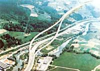
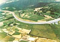
The North South route will be as follows: Aduna Connection with EN-I, Billabona, Elduain, Berastegi, Leitza, Areso, Gorriti, Azpiroz, Lekunberri and Irurtzun; here will be a union with the existing autostrategy. This route is defined between Aduna and Lekunberri, but not between Lekunberri and Irurtzun. Therefore, the characteristics of the works shown below will be those corresponding to the aforementioned trillo, section Aduna - Lekunberri. The route of the motorway in Gipuzkoa will be 16'8 km and Navarre 16'4 km.
The Oria Valley, the starting zone of the Gipuzkoan section, is located at the height 45. The Gipuzkoan section ends in the area of Leitza at cota 615. This difference of heights makes the motorway have an ascending slope to the limit of Navarre and Gipuzkoa. The highest point of the motorway is located opposite Gorozmendi. This point is located 12,800 km from Aduna.
Thus, the one that climbs to 5 kilometers in the valley of Araiz has to climb 12,8 kilometers by the highway.
The motorway will not have radius curves less than 250 m. The curves will be clotoids, that is, the radii will vary depending on the route and the number of straight sections will be very reduced following the usual rules.
The specific speed of the motorway will be 80 km/h.
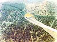
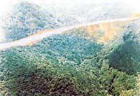
The territory is very mountainous so you will have to carry out land movements and tunnels. The proposed tunnels are not very long and are not believed to have a high degree of difficulty if geological reports are observed. However, tunnels are always an obstacle for engineers and also a weak point in the media, as they require ventilation, lighting and special care.
They present landscape and ecological advantages, but present risks of accidents and limitations to special transport.
The Navarra-Gipuzkoa motorway contemplates the construction of three tunnels in the case of Gipuzkoa. One of them, that of Urdaleku, of 350 m and another of 250 m and 200 m. In Navarre, in Azpiroz, a tunnel of 230 m will be built and in the section Lekunberri-Irurtzun, according to the needs.
The tunnels will be independent for each of the roads and their surface will be similar to that of other self-stratification tunnels, with two circulation lanes of 3'5 m each, 1.5 m arcenes and 1 meter sidewalks.

Regarding the cross-section of the motorway, we can indicate the following data: 2 lanes 3'5 m, 1'5 m outer arch and 0'5 m interior, median separation of 1'5 m and 0'5 m outer berms. Therefore, the tread road is at least 20'5 m.
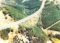
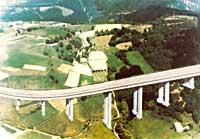
This building will have important bridges and viaducts. The trillo that will begin in Aduna will have large bridges and viaducts to save the Oria river, the Madrid-Irun railway and the EN-I highway. Later several bridges and viaducts will be necessary to overcome some channels, valleys and roads. Particularly noteworthy is a bridge of about 400 m, two of 200 m and a special bridge that crosses the Leizaran River on the limit: In the Navarrese trillo a viaduct of 300 m, another of 200 m and several upper and lower steps.
On the other hand, in parallel to the construction works, other environmental protection actions will be carried out. Special attention will be paid to the planting of native species, the treatment of clearing slopes (grass planting), the conditioning and rounding of margins and the planting of trees.
It is a question of preserving the impact of native fauna through the construction of numerous steps under the motorway.
Decanting chambers will be built to avoid possible damage by discharges of dangerous products in the surrounding rivers and streams. In this way, the liquid poured in the causeway by an accident, will remain in the pot and will be collected later.
Other less common jobs are braking or stopping roads. The reason is: The Gipuzkoa trillo has a slope of 12.8 km, reaching in some cases a slope of 6%. Therefore, if a vehicle, even heavier, is forced to stop for failure, it is recommended to have sporadically the sand road next to it.
There will be no shortage of surveillance and assistance services, since in the 33.3 km of the motorway any emergency can occur.
As for the links, they are foreseen: In Gipuzkoa Aduna, Amasa and Berastegi, and in Navarre Leiza, Areso, Gorriti, Norte de Lekunberri and Sur de Lekunberri.
In addition to the stops, viewpoints will be enabled to enjoy the beauty of the environment.
If the forecasts made by both administrations are fulfilled, in 1992 the work will be about to end.
At this time the Technical and Economic-administrative Conditions Sheets are available. The project has begun to be drafted in March of this year and will take place around a year. The obtaining of land of occupation will require the expropriatory processing, which will allow the beginning of the works in 1989.
The cost forecasts in 1985 are as follows (Aduna - Lekunberri).
- Gipuzkoa 10,000 million pesetas
- Navarre section 12.000 million pesetas.
It is estimated that between Lekunberri and Irurtzun 12.000 million will be spent.
These amounts should be specified more throughout the year 1987.
As for distances, the most differentiated sections will be:
Donostia-San Sebastián-Aduna 15 km Aduna-Limitada with Gipuzkoa 16'8 km Muga con Lekunberri Gipuzkoa limit 16'4 km Costillar de Lekunberri-Enlace de Irurtzun 18'2 km Irurtzun 15 km Total (Donostia-Pamplona) 81'5 km
Taking into account that the average speed will be 100-110 km/h, it will take 47 minutes to travel the entire route.
Buletina
Bidali zure helbide elektronikoa eta jaso asteroko buletina zure sarrera-ontzian


