


Weather forecasts are half
The truth is that meteorology is not exact science. This is recognized by the experts themselves, who indirectly include the word probability in their predictions. And for this they have a fundamental reason: the complexity of phenomena.
The atmosphere is a giant thermal machine that the meteorologist asks you to accurately indicate what your evolution will be at a given time and place.
But in this machine there are different aspects. If in the equatorial environment there are, for example, wind regimes, for a long time there will be stable weather situations, but in the territory in which we live the weather is much more unstable; it can vary in a few hours.
Rain is an easy to explain phenomenon. Simplifying the problem, there are two types of air: cold and heat. Hot air may contain more water vapor than cold. A cubic meter of air at a certain and fixed temperature can contain a maximum amount of water vapor. It is said that the air is saturated when it has that maximum amount.
If the temperature of saturated hot air drops, the existing water cannot remain in steam (the air does not support everything) and condenses into numerous fine drops. This is how fog (near the ground) and cloud form (above). If the temperature drops further, the fine drops are collected forming larger and making rain. When the temperature is colder, fine drops can solidify into snow.
In order to make meteorological predictions, it is essential to know where the masses of hot and cold air will flow. The advertiser wants to know where hot air and cold air will be concentrated. In this place, hot humid air cools causing clouds or perhaps rain.
The cloud can also form differently, for example, because the hot air cools when it rises from the bottom up.
In any case, pressure is very important for air travel. The pressure will depend on where the air masses go. The place where the pressure is high is called anticyclone and the place where it is low is called depression.
It seems that the air masses would have to go from the place where there is much pressure to the lowest, but that is only true in the equator environment. In our territory something else happens. Given the Earth's turn, another force also acts: Coriolis forces.
These two forces cause the air to move in the direction of the lines of equal pressure. In the northern hemisphere the air moves around the depressions in a clockwise direction and in the southern hemisphere it behaves from one side to the other.
Central depression in Britain usually means: The arrival of wet air on the Atlantic side and the risk of rain. The place where it rains is usually between depression and the old man, where atmospheric pressure changes rapidly. Therefore, if there is a decrease in pressure in the barometer (which is accompanied by depression), there is a risk of bad weather.
Meteorologists, when making their predictions, do not capture the atmosphere as a whole as is reality. The atmosphere itself is very complex. Meteorologists use a simplified atmosphere model. Its objective is to know the state and evolution of anticyclones and depressions through the calculations made in this model.
They collect data from around the world (sometimes incorrect) and applying these to the simplified model perform very long and complicated calculations. Only a dozen centers in the world will be able to perform these calculations.
With the results of these centers in hand, the local meteorologist makes his own leaks to announce them on radio, newspaper or television.
The results in the centers are not accurate. The calculated mathematical models offer descriptions with large gaps that the meteorologist of each place must interpret with his experience.
Today, meteorologists cannot function on a small scale. In the afternoon they will talk about a storm, but not at what point and at what time. On the one hand, the result given by mathematical models should be consistent with reality and, on the other hand, small-scale prediction (for example, for a given country) should not fail.
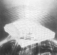
In the simplified model used by meteorologists, the atmosphere is divided into boxes or cubes. Inside each of these boxes the situation is supposed to be the same at all points; pressure, temperature, humidity, wind speed, etc. are equal.
The part of the box has a length of 100 kilometers and it is considered that the parameters of its interior can vary slightly from half an hour to half an hour, so that the situation of a cube modifies the following.
To bring the model closer to reality, many factors must be taken into account: the relief of the earth (which makes the air rise, cool), the nature of the earth (because sunlight some reflect more than others), the temperature of the earth, humidity, pressure, etc. The model is immediately complicated if we want it to be reliable and the calculations are very complicated. The only way to facilitate calculations is to reduce the number of boxes. But the calculations of the boxes of 100 kilometers of advantage already require the largest computers in the world. At the height of the atmosphere they occupy fifteen boxes to perform the calculations, being the boxes near the sun finer.
With this atmospheric distribution, these large computers, like Cray 2, need half an hour to calculate the prediction for a day and two and a half hours for a day.
Given the trajectory and experience accumulated to date, it can be said that the model of boxes of 100 kilometers also fails many times. In predictions for three or four days, the risk of not succeeding is even greater and the reasons for it may be different. On the one hand, the model used is not perfect. On the other hand, the data on which they are based are sometimes not correct. The dimensions of the boxes are high and within a box there can be differences (for example, from one city to another).
The model normally used does not cover the entire World and is shown to cover the entire northern hemisphere, for example, to predict the time of Euskal Herria four days earlier.
Errors occur at first, in data that is entered into the computer. There are hundreds of thousands of boxes spread around the world and each corresponds to a dozen meteorological parameters twice a day. Hence the millions of daily data needed. However, those actually received daily are approximately: 15,000 on surface, 3,000 aircraft, 1,500 satellite measurements, 3,000 wind measurements, 1,500 radio probes, 800 balloons, 200 buoys, etc.
Data collection is relatively abundant in developed countries, but very scarce in poor countries and in the oceans, except in the usual lines of ships or planes.
On the other hand, instead of initially redefining the basic data in each calculation, experts prefer to modify some data based on the measurements they receive and based on the situation they have calculated six or twelve hours earlier.
This change is quite complex. It is not enough to replace one value with another. This new value must be justified in advance by the existence of errors in any physical measure. Therefore, the computer rejects 5% of the measurements received. But sometimes the discarded data can be correct and important, as in the creation of a cyclone.
However, according to experts, long-term forecasts should take the following steps:
- Get much more detailed data. In addition, these measurements should be made much more spread around the world.
- The model should cover everyone to perform the calculations.
- The boxes taken should be smaller. At a distance of one hundred kilometers, such as the top of Gorbeia and Bilbao, are considered points of the same level, which means an excessive simplification.
But taking these steps is very expensive. If the side of the box is 50 km, the number of boxes is eight times larger and the time needed to perform the calculations. As a result, the announcement would be published too late and would be useless.
However, meteorologists are infringing other ways. Globally, for example, they divide the atmosphere into large boxes, but divide it into smaller boxes that occupy a large city. However, the union of the two large-scale and small-scale models creates problems.
It does not seem, therefore, that the predictions made in the current situation for more than a couple of days have a great reliability. Even within two days meteorologists fail many times. This is what we think at least until we hear a new theory from Arantzazu expert Pello Zabala. And the meteorologist amezketarra recognized by radio that the forecasts themselves do not fail, the weather is what is sometimes neglected. It cannot be denied that it is from Fernando.
Buletina
Bidali zure helbide elektronikoa eta jaso asteroko buletina zure sarrera-ontzian


