


Lost in length. The serious problem of navigation throughout the centuries
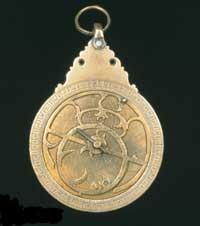
The latitude measurement system was proposed by the ancient Greeks. To do this, Hiparco proposed to study the position of the stars, since seeing the north and the south these positions change as a spherical sign of the Earth. Of course, to use this method, it is necessary to know the size of the Earth. This problem was solved seventy-five years later by Eratosthenes, who measured the radius of the Earth. Therefore, knowing the dimensions of the Earth and measuring the angle of the Sun with respect to the equator, the latitude can be calculated. Easy, right? Maybe not, but better try it than lose it at sea.
The possibility of measuring latitude greatly facilitated navigation; only by measuring an angle could it be known to go north or south. The length, however, was a serious problem, the XVIII. At least until the twentieth century. There was no way to know how much a boat would sail to the east or west. And they could not calculate distances with trips. For example, between Europe and America could not be defined. Neither from the point of view of the stars or the Sun can the length be calculated, since due to the rotation of the Earth, before or after the same stars are seen near Bilbao or Boston.
Measuring length was not just a navigation problem. There was often a political problem. One of the most significant examples of this was the return of Columbus from America. The ownership of newly discovered lands was at stake. Castile and Portugal, the largest military forces in Europe of the time, began to discuss to get these lands.
On 7 June 1494 the local authorities signed the Treaty of Tordesillas. According to this pact, the world was 'divided into two'. All the territories found to the west of a border belonged to Castile and to the east to Portugal. But this limit had to have a certain length and had no reliable techniques for their determination. The debate intensified.
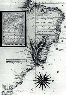
In the Treaty of Tordesillas it was determined that this limit would be placed to the west to 370 leagues of the islands of Cape Verde (370 leagues are approximately 2.055 kilometers). Of course, this text brought problems. On the one hand, the text did not specify which island of Cape Verde would be the reference; the archipelago has a width of 300 kilometers from west to east, so from an island or from another there is a big difference. On the other hand, the pact did not establish that these 370 leagues should be measured in the latitude or equator of Cape Verde. Finally, as mentioned above, in practice they had no technology to measure this distance, that is, if a new territory was discovered, they could not know which area it was in.
For the authorities it was very important to measure length, so they used a lot of money in this investigation. Astronomers, geographers, and navigators were given a lot of money to solve this problem. And in addition to investing money in research, they organized awards. The best-known award was awarded by the British government in 1714. For the inventor of the technique that provided the length of a ship with a degree of precision, a prize of ten thousand pounds, fifteen thousand pounds with an accuracy of 40 minutes and twenty thousand pounds with a precision of half degree.
In the hope that the solution was in the stars, most undertook the preparation of specific catalogues of stars. Thus the latitude could be measured. But not the length. The solution consisted, however, in the realization of a precision watch in which the position of a ship in an instant was determined by calculating the difference between the two hours, that of the outgoing port and that of that position, both simultaneously. With it determine the length.
In 1761, the British John Harrison managed to make this watch based on docks. Through this watch, the length could be calculated more accurately than half a degree, and yet, they only gave it half the prize, because the organizers of the contest did not believe that the length could be calculated without performing an astronomical observation. Finally, twelve years later he won the full prize.
Published in 7K.
Buletina
Bidali zure helbide elektronikoa eta jaso asteroko buletina zure sarrera-ontzian


