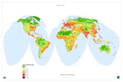

Map of the shadow
2002/10/23 Elhuyar Zientzia
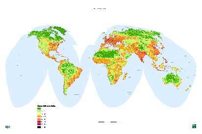
The map has come hand in hand with the American organization Wildlife Conservation Society. In this map, human influence in all areas of the Earth has been captured and represented through the colors, from green to black; the green regions suffer the least human impact and vice versa those marked in black.
Through the map, the environmental organization has calculated the percentage of surface of the humanized land, regardless of the sea. And the data indicate that there is 83% in this situation, that is, the forests of Alaska, Canada and Russia, the plateaus of Mongolia and Tibet, and everything that is not the great Amazon region. In addition, 98% of the land suitable for planting rice, wheat and corn is already exploited.
This type of maps, in addition to being very useful for the design of local management plans, have pointed out the members of the organization that serve to raise awareness of the people, since looking at the map we are aware of the enormous influence of the human being in the ecosystems.
Data on areas exploited by humans, infrastructure and human settlements have been collected for the map. Geographic data collection systems have improved significantly in recent years, especially thanks to satellite images, and thanks to this technology it has been possible to complete what has been called the human shadow map.

Gai honi buruzko eduki gehiago
Elhuyarrek garatutako teknologia