


Basque Coast (and XIII): Cliffs of Bizkaia (and II)
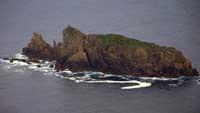
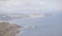
From Bakio to Punta Legorarri
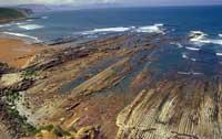
In the coastal part that extends from the bay of Bakio to the cape of Legorarri, also known as Billano, appears the dark flysch, formed by the clayey and sandy paintings of the Middle Cretaceous, which we have described from Endata to Lekeitio and from Bermeo to Gaztelugatxe. As we have mentioned on numerous occasions, we will not extend here to talk about this structure.
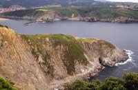
The geomorphological elements created by the erosion differential are especially relevant and spectacular in this coastal stretch. The clearest examples are the bays of Bakio, Barasorda and Armintza, Cape Legorarri and Billano Island. Bakio Bay is one of the most characteristic places of all. Being located on a diapiro, it has eroded much faster than its surroundings and in it you can see a clear entrants of the coastline, full of quaternary sediments.
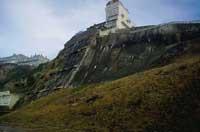
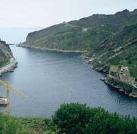
Barasorda Bay is also known in this coastal stretch. The desired nuclear power plant is more famous than its geological and ecological value. Fortunately, despite having spent twenty years, last year ended the sad trajectory of the Lemoiz nuclear power plant, which represented the nuclear future of Euskal Herria. However, they have remained there, so that we all remember, the ecological and landscape damages caused by the construction of the central. Unfortunately, the current political leaders have done everything possible to make new use of infrastructure, without showing the intention of recovering the region.
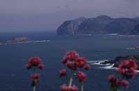
If we associate with ecology, in addition to the tidal and cliff ecosystems of this area, other characteristics can be highlighted. Among others, the coastal holm oaks, the species of tropical ferns located on the slopes of Mount Jata, between Bakio and Armintza, and the Urtzuri River, born on Mount Ermua and flowing into Armintza, and the Cormorán moñudo nidizante ( Phalacrocorodax Pelagelis and Txekhybatres) stand out.
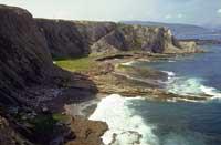
From Legorarri to Sopelana
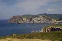
In this stretch of coast you can see a flysch of sandstone and marl of the Upper Cretaceous, the same structure that we mentioned when we studied the south of Lapurdi. However, the structure does not appear the same throughout the stretch: The flysch of Legorarri is older and darker, since between the calcareous and marl layers can be distinguished sandstone and lutite layers, while as we approach Sopelana these layers disappear and their color is clarifying; when arriving at the beach of Arrieta-Atxabiribil of Sopelana, the parts of the Mesozoic Face of the disappearance are preserved.
It is worth mentioning, on the other hand, the outcrop of the small diapiro of the area of Sopelana, whose consequences for its small size are not very significant.
Erosionability is very high throughout this stretch and, as we have already said when analyzing the cliff of Zumaia, it is quite evident the retreat of the coast. Its consequences are the wonderful beaches of this area and the large platforms of abrasion.
On the other hand, the bay of Astondo, at the mouth of the river Butrón, where you can find the most important geomorphological elements of this area.
From the ecological point of view, however, it can be said that the characteristics of this coastal stretch have already been analyzed, since nothing that differs here we find. However, the natural structure of intertidal and cliff ecosystems has remained intact and therefore has maintained a great biodiversity, making it the most suitable region of Bizkaia for those who want to analyze them.
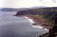
From Sopelana to Arrigunaga
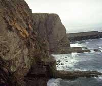
Continuing with the march that we have finished on the beach of Arrieta-Atxabiribil, we will return to enter the territories of the Tertiary. In it, remembering that the Pyrenees once rose, you can see the flysch and some strata of sandstone described for the previous part. The high cliffs of this stretch are almost vertical compared to the sea and at its base open wide coves that house wonderful beaches, caused by differential erosion.
In the streets closest to the Abra de la ría del Nervión there has been a curious geological phenomenon in recent years: in the sediments transported by the river, steel waste has predominated, which solidifies rapidly, giving rise to the formation of young and singular stones, called Beachrocks. It is very easy to distinguish the stones of the Tertiary from those of the Quaternary, since the first ones are light and vertical with respect to the sea, while the second ones are darker and horizontal with the sea.
The most important geomorphological element in this area is Cape Galea. It is formed by cliffs of vertical stratum, but something more leads you to list this spot among the main coastal enclaves: The Vizcaíno synclinorio penetrates the sea and is witness to the difference of inclination of the cliffs layers of the right and left margin of Cape Galea.
If we have to do an ecological study, unfortunately, we will have to mention the massacre caused by man. Pollution has impoverished the intertidal ecosystem and a large number of living things have disappeared, as well as human influence on the beaches and high cliffs, and the current deterioration of the natural structure. If some communities of typical plants have managed to survive, it has been because it is difficult to reach the cliffs, and not on the other hand.
From the left of the Abra to Cape Kobaron
The geological structure of this last stretch of the Biscayan coast is similar to that studied in the stretch between Lekeitio and Bermeo. In fact, in addition to the gray-blue marls and flysch of sandstone of the lower Cretaceous, in both you can see the biohermes originating from the sandy ones. Due to the characteristics of the geological structure, the erosion of the sea in these areas is low, which, in addition to generating narrow platforms of abrasion, has originated Cape Lucero.
As for the geomorphological elements, the cape Lucero and the bay located at the mouth of the river Barbadun stand out. It is a bay created by orogenic impulses, where is the wonderful beach of La Arena. In addition to those mentioned, the most important value of this stretch of coast lies in the ecological aspect. The microclimate of the area is warm, dry and sunny and the conditions of the Mediterranean are similar, so you can find populations or communities that are not found throughout the coast of the Basque Country.
Although the human intervention has been intense, there are still small espadrilles ( Quercus coccifera) and holm oaks ( Quercus ilex); as for the fauna, the Mediterranean field liron ( Eliomys quercinus), between mammals and the Esquín trident ( Chalcides chalcides), among reptiles.
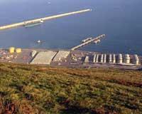
Abra del Nervión has always been biologically rich, but in the last century the pollution caused by industrial activity has endangered its ecosystem. After the effort made in recent years it can be said that the situation is recovering, but a new rival has recently appeared: Bilbao superport project. This would totally distort the entire environment and, which can be even more dangerous, could re-release the pollutants accumulated in the background. If the pollutants were lifted from the bottom and suspended in the water, it would risk accumulating into food chains and, of course, affect living things throughout the region. How far can human irrationality go?
Conclusions
In this wide range of articles we have tried to conduct a detailed study of our coast. First, we consider that the ecological, geological and landscape value of the Basque coast is very high. We have seen that our coastal ecosystems have a great biodiversity and many characteristics, among others. However, human intervention is increasing and the consequences of the phenomenon that is occurring throughout the planet are beginning to be seen in our environment: the rate of human population is increasing and, therefore, degradation, pollution and speculation are increasing. If the dynamics of recent times do not change, therefore, we could be about to lose the wealth of our coast.
Before it is too late, general planning should be put in place to promote coastal conservation. We believe that this planning should be articulated in three main axes: the elaboration of an exhaustive inventory of natural spaces and species and the implementation of the political and administrative measures necessary for their recovery; to address the general problems it is essential to coordinate the work of the different administrations and institutions and, finally, to sensitize all of us on the seriousness of the problem.
Start the race against time. Given the situation, we have very little time to try to restore our environment. There are only two main options: the concrete coast or the living coast. And we all have to decide, and you too.
Cliff protection figures and their use in the Basque Country
INTERNATIONAL
Biosphere reserves (UNESCO Man and Biosphere Project) are the Gernika-Mundaka Estuary Biosphere Reserve, which includes Izaro Island and Cape Ogoño.
The EU CORINE Programme BIOTOPO Project Inventory includes:
- Cliffs to Cape Barrika-Matxitxako.
- Gernika-Mundaka estuary, including Cape Ogoño.
NATIONAL
According to Spanish and French coastal laws, all the cliffs of Lapurdi, Gipuzkoa and Bizkaia are on public property in dry sea.
Conservatoire de l´espace littoral et des rivages lacustres is a French public organization responsible for the conservation of coastal ecosystems and wetlands. To enhance conservation and recovery, buy the richest ecosystems. Under this model of protection are the areas of Abadía and Exanzabal.
This French protection model Site clasee designates areas of high historical, natural or landscape value, without any practical protection. This is the Bay of Loia in Abadía, the Corniche in Urruña and the Pointe de Sainte Barbre in San Juan de Luz.
REGIONAL
Catalogue of enclaves and natural environments of interest of the Autonomous Community of the Basque Country It contains the following cliffs:
- Surroundings of Zierbana
- Galea-Barrika Cliffs
- Surroundings from Gorliz to Armintza
- An environment for peace from Armintza
- Environment Gaztelugatxe-Matxitxako
- Holm oaks of the Mundaka estuary
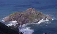
- Izaro Island
- Related information
- Mount Otoio and cliffs
- Cliffs Mendexa-Berriatua
- Cliffs from Saturrarán to Mutriku
- Coastal stretch Endata-Zumaia
- San Antón de Getaria Island
- Streams of Mount Mendizorrotz
- Cliffs of Ulía
- Mount Jaizkibel
Project of Land Management Rights (DOT) The rías that appear in the different protection figures of that project are the following:
- Active conservation: Related information
- Strict protection: Coastal stretch Galea-Barrika, Astondopunte-Armintza, Armintza-Bakio, Gaztelugatxe-Matxitxako, Mutriku-Saturraran, Costa Endata-Zumaia, Arandomendi de Pasaia and Mount Jaizkibel from Mitxixola to Areotegi.
Buletina
Bidali zure helbide elektronikoa eta jaso asteroko buletina zure sarrera-ontzian


