Nazca Astronomical Tracks
the tracks.
Discovery
The
set of Nazca lines was declared cultural heritage of all people in 1995. Despite hearing and/or reading many things about this magnificent work done by man, it is difficult to become aware of the beauty of the work if we leave and do not see it from above. From the plane the images are perfectly visible and, in the absence of this, it is essential to climb to a viewpoint of sufficient height. Seeing the lines from the ground is like not seeing anything, since when we are on earth we lose the necessary view to know the details and measures that the authors had achieved when drawing the geoglyphs. It is also very difficult to find on earth the lines that indicate the environment of each image. Despite the absolutely prohibited grooves, it would be practically impossible to differentiate the lines from the other existing tracks, among which are the numerous wheels left by vehicles that have traveled for years, areas that have remained unprotected for a long time. It is worth noting the deterioration caused by vehicles on several lines.
As we
have just mentioned, it is practically impossible to become aware of the set of lines from the land itself, which made us unaware of the geoglyphs until 1939, when the American scientist Paul Koso flew over the region during some research. We say that these investigations referred to irrigation systems used by pre-Inca peoples. When Kosok first saw the lines drawn on the ground, he considered them as part of a hydraulic engineering work by former inhabitants of those arid areas. However, he soon changed his mind, the day he chose to pass over the region was necessarily on June 21, the day corresponding to the winter solstice, in which the direction of sunset coincided with that of a line drawn on the ground. Did those who drew the lines intentionally or unconsciously? Did you know enough precision about astronomy?
Description and research: Related information
After discovering the importance of the lines, Kosok pointed out that the ensemble formed by the geoglyphs was the largest astronomy book in the world. The first theories and works of this scientist were followed by mathematics Maria Reiche. This woman, of German origin but who got Peruvian citizenship, spent her whole life researching the images of Nazca. Today, a hundred kilometers from the town of Ica, on the road that links Ica and Nazca, you can visit the Maria Reiche Museum, in which you can see some of the tools that the researcher used to measure his lines, as well as photographs of the images of the earth, the biography of the mathematician and the copy of the classroom in which he worked for years.
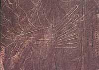
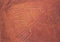
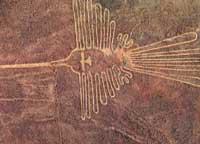
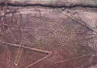
Thanks to Reiche, we currently have detailed maps of that wide sea of sand, of more than 200 km2 of extension, which account for all the images made on earth. Undoubtedly, the figures of the animals stand out: whales, spiders, monkeys, dogs, lizards and, above all, birds. A total of 18 birds were found, including hummingbird, condor, ditch and papagaya. The most spectacular is the image of the hummingbird, a hundred meters long, with perfect rainfall; highlights the long and singular peak of the bird, which manifests itself in the dark plain on a hill.
However, these animal figures (15 to 300 m long) are only a small part of all of them, since most are sets of lines that form geometric figures. There are mainly trapezes, rectangles and several spirals. Some of these figures are up to ten kilometers long.
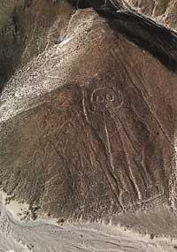
Another curious image is the so-called astronaut. Located on a hillside, E.T. from the Spilberg film. It looks like the famous, with her fingers towards the house. It seems that this human figure and similar figure found in other hills are older than those drawn on the plains.
To draw the geoglyphs of Nazca on the ground were made some striae of about 20 cm of depth in the ground and, later, in order to highlight the stretch marks, were placed on the sides of the furrows some stony from another place. One of the chemical components of these rock feces is iron and after years of solar influence, a dark oxide layer has formed on the stones. In this way, they achieved a beautiful contrast of colors: at the height of the light of the sand of the furrows and gravels appears the darkness of the stony.
The images have been maintained to date due, on the one hand, to the geological characteristics of the soil and, on the other, to the rigidity of the climate. Surprisingly, according to data, in these areas only rains half an hour after two years.
Stories and explanations
The most characteristic feature of the Nazca lines, apart from the precision and the great dimension, is that little is known about them. Despite the tireless performance of María Reiche, we still do not know the origin of the lines, the method they used to draw on the ground or the objective of the images. It is possible, however, that this mystery about the geoglyphs of Nazca is precisely the one that awakens the most fascination. Among other things, curious explanations have been given about the images. But there are also all kinds of interpretations.
There are those who think that the sets of lines are divine representations, and that the intention of the authors was that the gods could only be seen from heaven. Others say the images are related to water worship. In fact, the cultures lived in that desert have always given great importance to water.
And, of course, with curious explanations: According to some, these are tracks for the landing of extraterrestrial beings. Or what says Dr. Javier Cabrera, who has opened the Museum of Stones in Ica: they are tracks for the parking lots of advanced human civilization. This civilization, moreover, was contemporary of dinosaurs. According to Cabrera's curious Theory of Humanity, human beings who inhabited the Earth millions of years ago achieved a great advance, but a catastrophe, probably caused by humans themselves, caused the disappearance of the ancient civilization. What is this theory based on? Cabrera maintains that he has found hundreds of stones somewhere he only knows, and that in them are recorded spectacular images of this type: since men fight against the great dinosaurs, through complicated interventions open to the heart or a mundi map in which you can see the five continents to the so-called Atlantic. It is evident, therefore, that Cabrera's arguments are truly confusing, although Cabrera himself will explain it to anyone who accesses the Museum of Stones, after paying the corresponding entrance. This man finds everywhere the reasons that support his theory, as well as some of the figures of the traditional tapestries of the Paracas culture.
According to Cabrera's explanations, some of the men of ancient and advanced civilization, contemporary of the dinosaurs, were able to cope with the aforementioned disaster and had to flee from the Earth; they went to the Pleiades in the space spaces, and the Nazca lines were precisely the magnetic tracks for the takeoff and landing of these spaces.
In those who visit this unique Museum of Stones there is everything; some have been able to know these theories through some book and have decided to go to it, even from the farthest places in the world. But most, of course, are convincing, because it is incomprehensible why he has not drawn the origin of the stones, if, as he says, they are real. Aside from this kind of eccentricities, it is clear that if we want to investigate the lines from a historical perspective, we have to go to the Nazca culture.
Nazca Culture
This culture settled in a region of southeast Peru, bounded by three valleys: Nazca, Ica and Pisco. Nazca culture a. 350 BC It boomed to 650 and was one of the most outstanding seal cultures. This culture was a direct heir to the civilization of Paracas, which can be seen in many respects, especially in the development of the textile industry of the Nazca and in some human interventions, since the Nazqarras, like those of the Paracas civilization, were skilled in the deformation and trepanization of skulls. However, in other areas, such as ceramics, the Nazqarras outperformed the previous ones.
It was a sedentary society dedicated to agriculture and the growth of flames. It can be said that their political system was democratic; according to the traces found it seems that they had no powerful leaders, so it has been considered that there were no significant differences between the classes. Nor does it seem that religion was very important, and in terms of relations between men and women, they seemed egalitarian. No large temples or souvenirs were built except geoglyphs. But ceramics and textiles are spectacular and spectacular. The capital of the region was in Cahuachi, about twenty kilometers from the current town of Nazca.
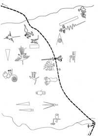
Because the southern coast of Peru, especially the Nazi valley of Rio Grande, is very dry, farmers had to devise methods to measure time as accurately as possible, in order to properly maintain agricultural production, that is, control all aspects of production: planting, harvesting, roturation and irrigation. Among the findings made by archaeologists in the region of Nazca are the agricultural terraces (an unmistakable sign that took great care of the soil), the canals, the aqueducts and, apparently, some small dams. As mentioned above, this type of research was the starting point for the search for geoglyphs. Apparently,
the calendar they used was very complicated, and its base was a set of lines tremendously drawn in the arid plains of Nazca.
Chronology
We do not know much about the time when the lines of Nazca were drawn. Thanks to the work of researcher Reiche we know that the lines were made in the era of Nazca culture, in the first millennium d. C. Although it is not a very accurate data, we must take it into account by default.
On the other hand, studies conducted by scientists Gerald Hawkins, Dorothy Menzel and John Rowe showed the relationship between land lines and ceramic vessels made by the Nazcathars, so that most geoglyphs can be associated with two specific epochs of the Nazca culture, since the images of the earth are very similar to those that appear in the vessels of those times.
It should also be noted that some lines are drawn on others. It seems, therefore, that in some cases the illustrators did not know that before others had chosen the same place to draw. However, in the vicinity of the areas where the earth lines are located, fragments of ceramics, piles of stones and even garbage have often been found. Apparently, the sliders wanted to show who had done each work.
Using lines
As we know, the deepest studies on geoglyphs are those of Maria Reiche. He made several measurements to know the technique used to draw the lines and also dealt with the meaning of the images. According to Reiche's theory, most Nazca lines have to do with astronomy, always with the intention of using them for agricultural purposes. He did not say that all sets of earth lines were instruments for measuring the movement of stars, the Sun and the Moon, but all researchers agree that many of the images serve to observe solstices and other astronomical phenomena.
It seems, therefore, that the geoglyphs were not made to look from heaven, but to use them from the earth itself. Let's say that this type of line is not only in Nazca, but similar lines have been found elsewhere in the Peruvian desert. In most cases they were made for astronomic-related purposes or for use as a calendar, but there were also images that had another task: they were roads, tracks and signs for travelers. For example, in Paracas, at the front of the bay, there is a giant cactus drawn on the slope of a hill; the image can be considered as a sign for sailors and fishermen in the area are called candlesticks.
Also, the scientist Reiche said that many sets of lines were expressions of constellations and that probably the inhabitants would celebrate in the same geoglyphic rites and festivals related to agriculture and religion. Some of the discoveries in favor of this theory are similar to those of all figures: in the case of the spider, the entrance is in one leg, in the birds in the peaks, and the monkeys have that entrance in the tail. From these entries we will reach similar large squares, which may be linked to astrological issues.
In addition to María Reiche, other prestigious researchers have investigated the Nazca lines. In them we will highlight the Gerald Hawkins we mentioned above. This scientist, an expert in ancient astronomy, has carefully studied the relationship of lines with the movement of celestial bodies. The main conclusion is that it is impossible to find precise connections between the outlet and entry points of the celestial bodies and the direction of each of the earth lines. However, this result does not rule out Reiche's coherent theory. It can be said that the Nazqarites achieved the accuracy corresponding to the technical and scientific resources of the time in which the lines were made, and it cannot be denied that they had clear objectives when drawing the sets of lines.
We can say, without fear, that the images drawn in the plains of Nazca are like an ancient astronomical calendar in which the Nazqarites performed rites.
In any case, seeing the mysterious lines of Nazca today is something terrible, both looking from the observatory that has been prepared there, and flying over them by plane or helicopter.
Buletina
Bidali zure helbide elektronikoa eta jaso asteroko buletina zure sarrera-ontzian


