


The origin of modern navigation

The abundance of meridians generated discrepancies when calculating the time and navigation maps of the different states had different references. They had difficulties, therefore, when the sailors changed map from one town to another. Military planes traveling between Europe and America continue to have the same obstacle. American and European cartographers use different systems when defining Earth.
In October 1884, representatives of 25 villages met in Washington to decide what the meridian of 0 length would be. Although the French are pioneers in modern cartography and were not at ease, the Greenwich meridian was taken as a reference.
Some claim that the London meridian was chosen as Britain's largest marine power. Others, however, consider that 65% of the ships used the meridian of Greenwich and the other ten different meridians.
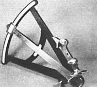
Sextants and chronometers, measuring devices of latitude and longitude, XVIII. They were improved at the beginning of the twentieth century. John Hadley, who in 1730 had made the octante, five years later John Harrsion completed the first chronometer of marine width. The Harrison chronometer was replaced by the old pendulum clock. The pendulum, which had two floors hanging, did not serve when there was bad sea.
When the meters appeared to accurately define the position, the cartographers managed to draw in their maps the oceans and continents respecting their real shape. Jean Picard had the measured width of a degree in the meridian of Paris in 1669. Three years later, with the construction of the Paris Observatory, the French cartographers began to work on top. By 1682, analyzing the eclipses and satellites of Jupiter, they had fixed the position of 24 places on the French coast. These data were used by Guillaume Delisle to produce maps published between 1700 and 1726. This guillaume is the first modern cartographer.
Surveyors who were measuring land also invented other complementary systems to define the position. Between the points, rods or chains were placed on the ground. The distance between points could be equal to or greater than 8 km. After measuring this distance, other points could be fixed by triangulation. The length of the rods was 20 feet (6.1 meters) and that of the chains of 100 feet (304 meters).
The measure of distance in rods has its drawbacks, since its lengths vary slightly by temperature and humidity. For this reason, the errors in the measure of the triangulation base were increasing.
The Italian and French agricultural workers began to use wooden poles with copper or brass ends. Between the rods they left a gap and the tarts are measured with wooden bars. The system was complicated, but they avoided stretching the rods and pushing them to each other.
When William Roy measured a line of 5 miles (8 kilometers) in southern England in 1784, he used pine rods from a steel chain of 100 feet (30.48 meters). The last measurement was made using glass tubes. Others used metal rods that compensated each other, that is, rods of different expansion coefficients. The Frenchman Borda used copper and platinum in 1792 and Bessel made the triangulation of Prussia in 1836 with iron and zinc rods.
In 1825, Thomas Colby invented a special compensated mast. He used different extensions with iron, brass and steel. Colby's meter was used in 1827/8 in the first triangulation of Ireland and England in 1849. The measurement speed was 6 rods per hour or 140 meters per day.
Although this system was sectoral, it was very concrete. When Roy made the measurements in Hounslow Heath (at the current Heathrow airport), he placed the glass tubes on a bracket that the soldiers kept so that they would not be damaged at night. At the time of verification an error of 1/158,000, five centimeters in eight kilometers was detected.
Buletina
Bidali zure helbide elektronikoa eta jaso asteroko buletina zure sarrera-ontzian


