


Lost in length
The impossibility of determining length was a very famous problem during the birth of the British John Harrison in 1693. In Europe, people on the street also knew that. For them it was a problem to be solved by scientists, as we do today with the cure of cancer. Historians do not know when Harrison knew the problem, but no one doubts that it was he who brought the solution.
Especially in coastal villages, the indeterminacy of length caused serious problems. During the time when John Harrison was born, many people died because they could not know the length of the boat at sea. The losses in length depended on storms and water currents. Many died sunk, drowned; either suffering an accident against the coastal rocks or, if they were long at sea, suffering a scurvy. If we could measure the length, the boats would take the most correct direction and the sailors would have more possibilities to face these difficulties.
Such a serious story occurred on October 22, 1707. An English army of five ships lost their way and suffered an accident on the coast of Brittany. Four of the five ships sank. In the end, almost two thousand people drowned because they sailed more east than they thought.
This accident had great repercussion. Among other things, the government wrote in 1714 a writing called Minutes of Length. In that writing he promised a great reward for the "discovery" of length: It would award a prize of 10,000 pounds to who measured the length with a precision of a degree, of 15,000 pounds if the accuracy was two-thirds of a degree and 20,000 pounds if it was half grade.
Ideas ideas for ideas

How could the length be measured? Even those who did not know the prize, launched many ideas to determine the length of the ships. Some complexes and other surprising. For example, for boats that did not have to go far from the coast, they tested very simple systems. During the vessel's navigation, a stick could be thrown into the water to measure the vessel's speed. The measure of the time that the container took to leave the stick allowed to know the speed. And knowing the speed and with the compass, the length could be easily calculated.
There were no simpler methods. But it gave many problems: the cane was not standing at one point, the boat did not always follow the same direction and, in addition, the method was based on many indefinite factors. Therefore, this system cost less than the sailor's instinct.
However, it was not so difficult to fix beacons at sea. Those who remain standing in a given place. A system based on this type of "mujones" was also proposed. It was a brave system: place fixed buoys and tie a small cannon to the buoys. The cannons fired at certain hours to refer to the boats sailing around. A curious idea. But before testing that system they realized that it had great difficulties.
On the one hand, they would have to fill the sea with buoy to be close to anywhere and be able to hear shots even in storm days, in practice it was almost impossible. In addition, in each buoy they would need a person to shoot and be much more clumsy and dangerous than working in a distant lighthouse. The idea, therefore, was suspended from the moment they began to study it.
Temporary key time key
In practice, the only reliable system was to measure time. Two places. If you can compare the time when the boat was with the time of London or Paris, you could easily calculate the length. But for this purpose they would have to carry on board a reliable watch that would allow to know at any time the time of the reference place.
But there was no suitable watch for sailing. XVIII. At the beginning of the twentieth century, the most accurate watches in the world operated by pendulums. And, swinging in the sea, the pendulums were nothing reliable.
However, in nature there were specific watches. Astros can be used as watches. It was a very good idea. In addition, if the stars served to determine latitude, why did they not serve to help measure longitude? Astronomical observation was always a good resource. Eclipses could be used, for example, to determine the hours.
In theory it was a good idea. In short, it was well calculated when eclipses would occur and when they would be seen from the main European cities. Therefore, if we observe an eclipse from the sea, knowing the latitude, we could easily calculate the length of the ship. However, the main problem was obvious, sun or moon eclipses are scarce. They are very occasional. It was no good idea to calculate the length at any time.
However, Jupiter's moon eclipses could be used more frequently. Galileo himself proposed this idea when he discovered Europe, Ganymedes, Io and Calisto. It was approximately 1610. Analyzing the orbits of those satellites and the usual: knowing at what time would be seen eclipses between them from London, the length of the ship could be calculated for many nights. These eclipses were much more abundant than those of the Moon and the Sun. Furthermore, although there were no eclipses, the positions of the four satellites could be used.
But, like the previous ideas, the observation of the satellites of Jupiter had great problems. To carry out this system, each boat should have a good telescope. And skilled observers, and from a boat in scale astronomical observation is not as easy as from land.
In addition, the system of Jupiter was not visible every night. There may be half a year on the other side of the Sun, seen from Earth. From time to time the moon itself hinders the observation of Jupiter. And much more important than that, if we were cloudy, they could not observe either Jupiter or anything else in heaven. On land, however, the method proposed by Galileo was very successful. It was applied in the mapera industry and reached great popularity from 1640, approximately at the time of Galileo's death.
Observatories Observatories
By 1650 it was evident that they had to measure time at sea in order to determine the length. It was clear that at the time of the measurement they had to know the time of a place of a known length. And, unfortunately, most thought that these watches should be astros. Unfortunately, the problem of length would not be solved like this.
However, this problem stimulated astronomical observation. To convert the movements of the stars into watches it was necessary to know them very well. That information was missing. Earlier astronomers, such as Danish Tycho Brahe, observed planets and stars and collected thousands of data. At first sight. But XVII. In the twentieth century, good telescopes could be used to continue observing.
Italian astronomer Giovanni Domenico Cassini made numerous observations. For the fame that this work gave him, he was invited to Paris, where he moved to live (in many cases it is known as Jean Dominique Cassin). Louis XIV was not at all scientific, but at the request of Cassini he authorized the creation of the Royal French Academy of Science and the installation of an observatory in Paris in 1666.
In England something similar fell. King Charles II was concerned about the problem of length. Believing that the solution was to be provided by the Moon movement, they asked astronomer John Flamsteed for advice. Flamsteed requested the construction of an observatory. Finally, in 1675 the new building was built in Greenwich Park in London. As is known, this observatory later became a world reference, both for the time and for the position of the meridian "cerogar".
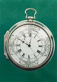
Watches of Harrison
The solution was brought by the work of John Harrison. Before facing the problem of length, Harrison had a reputation in the field of watchmaking. His first pendulum clock was twenty years old, in 1713, and seven years later he was asked to make a clock for a tower. It was installed in the park of Brocklesby in 1722 and since then works in it.
But a clock for the sea should be without pendulum, without pendulum and precise. In fact, it had to perform many inventions to make the watch accurate under sea conditions: anti-friction mechanism to avoid adding oil, two types of metals to make the parts compensate for the effect of temperature, etc.
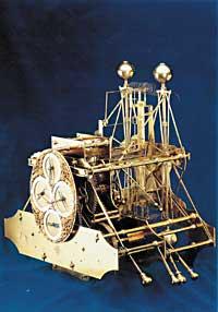
It is not surprising, therefore, a slow work. The first tide clock, H-1, was performed for five years. It was presented at the Royal Society in 1737 and reached great popularity. The watch was also tested on a cruise to Lisbon, ideal for calculating the length. But Harrison wanted to improve. It took four years to complete H-2 and dedicated 19 years to H-3.
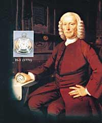
However, Harrison wanted to make a watch better and a year later he made an H-4 watch that looked like a pocket watch. This watch was carried on a navigation to Jamaica, which lost only five seconds in 81 days.
However, they did not give him all the prize to Harrison. For many, this did not solve the problem of length, since it was not based on astronomical data. The prize jury members asked Harrison to make two more watches. Finally, in 1770 he formed the H-5 with which he obtained the prize, two years later.
The world divided into two halvesAfter returning from America, the ownership of newly discovered lands was played. Castile and Portugal, the largest military forces in Europe of the time, began to discuss to get those lands. On 7 June 1494 the local authorities signed the Treaty of Tordesillas. According to that pact, the world was 'divided into two'. All the territories found to the west of a border belonged to Castile and to the east to Portugal. But this limit had to have a certain length and had no reliable techniques for their determination. The debate intensified. In the Treaty of Tordesillas it was determined that this border would be located to the west to 370 leagues of the islands of Cape Verde (370 leagues are approximately 2.055 kilometers). Of course, this meant a series of problems. On the one hand, the text did not specify which island of Cape Verde would be the reference; the archipelago has a width of 300 kilometers from west to east, so from an island or from another there is a big difference. On the other hand, the Treaty did not establish that 370 leagues should be measured in the latitude or equator of Cape Verde. Finally, as mentioned above, in practice they had no technology to measure this distance, that is, if a new territory was discovered, they could not know which area it was in. XVIII. Until the twentieth century no solutions were found. But by then it was already late. The solution needed it two hundred years before. There were fights and intrigues among which were kings, authorities and pope. And, somehow, they divided the world into two. As a result of this distribution, Brazil currently speaks Portuguese, but in all other countries of South America it is spoken in Spanish. |
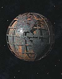
Roemer and speed of lightJupiter can be considered a clock in the sky. It has no drawn numbers or needles, but with a telescope four satellites are easily seen. And seeing their positions you can learn to read the time. In practice it was very difficult to measure the length through this clock at sea, but for the earth it was not so bad choice. For these satellites, the lengths of several European cities were defined. Among those who worked in this work was the Danish Ole Roemer. Roemer realized that observation was not the same if it was found near the Earth of Jupiter or if it was far away. The orbits of the satellites were calculated, but the calculation was not always accurate. Sometimes the error was large and sometimes small. In the end Roemer understood that the problem was clear. He needed time to get to Earth from Jupiter, farther and less near. The orbits of the satellites, therefore, were not accurate, since they saw the positions before the calculated when the planet was approaching and, on the contrary, they saw them later than calculated when the planet was moving away. |
Take your meridian
Why is there 'zero' length in London? Why is the Greenwich meridian a reference? The answers must be sought in history books, but, in short, it is something decided by man. Convention. Only something agreed. But the reference could be in any other city. And it is that everyone can use his own if he wishes (of course, this would entail great difficulties, since everything is prepared to be the Greenwich reference).
However, the first meridian has not always been in London. It has been present in other cities, according to the historical needs of each era. Ptolomeo, for example, put the meridian in Madeira and the Canaries. Others, in Azores and in the islands of Cabo Verde. And the meridian has been far from the ocean, such as Rome, Copenhagen, Jerusalem, Saint Petersburg, Pisa, Paris or Philadelphia. Why not put it in the portal of the house?
Buletina
Bidali zure helbide elektronikoa eta jaso asteroko buletina zure sarrera-ontzian


