
Is the growth of cities equal to the ecological catastrophe?
2001/01/28 Carton Virto, Eider - Elhuyar Zientzia
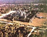
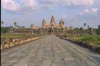
Formerly, the Khemer empire extended from the South Chinese Sea to Thailand and from Laos to the Malakar peninsula. XI. Its capital, Angkor, reached almost a million inhabitants in the 19th century, but 400 years later the city and the empire disappeared forever. What happened? Conventional theory culminates political instability. The authorities of the city lost control of power, in the provinces in which insurrections occurred and suffered attacks from neighbors. Finally, after an invasion, the angiors left the city forever in 1431.
But there are archaeologists who do not coincide with this theory. Among them are the Australian Roland Fletcher and the Cambodian Christophe Pottier, two of the two who are seriously working for another explanation. They believe it was more than the ceremonial zone of Angkor and that an ecological collapse caused its decline.
Residential neighborhoods
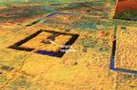
The theory of ecological collapse began to take shape in 1992. Pottier discovered the remains of about 600 buildings while exploring the south of the city and came to the conclusion that they could be traces of the place of residence of ordinary people. The temples and monuments were simple and most of the sculptures were made of wood. There was nothing to bring to museums, but there was enough information to reinforce new ideas and theories. The population of Angkorre did not live concentrated in the center of the city, but also in the surroundings. Moreover, for Pottier, most of the population of Angkorre lived outside the imposing central buildings, dispersed by wooden houses.
As non-conforming archaeologists, they began to explore ways to test the theory and they got a unique opportunity from heaven. Another archaeologist who worked in Angkor asked NASA for the Endeavour mission to take some images of Angor. It was accepted by NASA and in 1995 it had images in its hands. All the experts were amazed, as the images showed a network of land, roads, tumuli and irrigation channels that extended from the center of the city to the north. In total, Angkorre occupied an area of 1,000 square kilometers.

For Pottier and Fletcher, the meaning of these photos was evident. Angkorren lived more people than he imagined, suffered a huge ecological stress for years and eventually collapsed. The succession of events was, more or less, the following: as the city grew, more land was stolen from the forest for agriculture, and from north to south the river was filled with sediments. Sediments obstructed urban channels and surrounding rivers. The irrigation system began to degrade, the channels began to erode and the lands became impoverished. The inhabitants of Angkorre carried the imbalance to the end and in the end everything went by foot.
Credible theory
Subsequent studies have reinforced the theory of ecological collapse. However, it is not entirely clear whether the channels were used exclusively for transport and irrigation or whether people lived in their surroundings. To demonstrate this, samples have been extracted from the sediments of the channels, since if the theory of ecological collapse is direct and if around these channels there were people, signs of human occupation will appear in the sediments.
On the other hand, these sediments are also a way to know if the environment of Angkorre suffered or not stress. The study of pollen, small organisms, and carbon captured in sediments can give clues about the change in surface of the forest and the presence or absence of crops. With this information XV. You will be able to know what were the ecological conditions of the nineteenth century and imagine Angkor and its surroundings in its entirety. On the other hand, it is intended to remove similar tracks from the southern lagoon of Angkorre. The canals and streams of the city poured their waters into the lagoon of Tonle Slap, so the remains of the forest cleaning will also remain there.
It should be noted NASA's support for the demonstration of the theory of ecological collapse. Last year, NASA's PacRim Earth observation mission took new images of Angkorre. They have been made more closely and more precisely than those adopted by Endeavour. For the moment, only one image has arrived at the hands of archaeologists and have declared that it is enormous. All these images will allow to know Angkor in its ecological context and to be able to identify with greater precision the limits of the city.
Past subject matter
It is clear that from the archeological point of view it is very interesting to clarify why and how to disappear the city of Angkor. But it also has an interest for Cambodians, especially for Angorans living on the banks of the Mekong River.
Lake Tonle Slap is still an excellent source of food, water and fertilizer. In the first months of the year it hardly rains in the Mekong basin, but in time of the monsoons the water level can exceed 20 meters. They fall to the ground more water than the river and its tributaries can retain and most of the surplus is concentrated on Lake Tonle Slap. On the way sazona with fertilizer the farmland. In addition to fertilizers, floods transport fish from the north to the lagoon.

The Mekong River and Tone Slap Lake are a source of wealth for locals, but how long? China has built a hydroelectric dam on the main branch of the Mekong River and plans to run another 14. Thailand, Laos and Vietnam have 15 dams in the tributaries of Mekong and Cambodia wants to build another 9. So many dams have revolutionized the flow and ecological balance of the river. 600 years later history seems to be repeated. The phenomena are the same: the habitat is being reduced and the global ecology of the lagoon is changing; the population is increasingly large and intensive agriculture predominates. Will you give them time to learn from the past?
From Cambodia to the worldWho has never seen American films? Who does not know the familiar neighborhoods of American films? Garden, garage and detached house. One next to the other, on both sides of the street and all the same. These neighborhoods are made according to models of low density occupation. Instead of building buildings with many homes in small spaces, they occupy large areas with small houses. Logically, the availability of large spaces is essential for the application of low density models. For this reason, this model is very widespread on the western coast of the United States, although in some places in Europe and Australia there are neighborhoods of this type. They are increasingly larger and appear to have an unlimited expansion capacity. In principle it does not seem that they can cause special damage. However, Pottier and Fletcher are not so sure. According to them, Angkor is an example of a low-density occupancy model. It was formed by a ceremonial center and neighborhoods that occupied hundreds of square kilometers. It was wonderful but it failed. Archaeologists consider that it can be similar to residential neighborhoods if they are allowed to expand without limits. |
Published in the supplement Natura de Gara

Gai honi buruzko eduki gehiago
Elhuyarrek garatutako teknologia