
GPS
2000/02/20 Kortabarria Olabarria, Beñardo - Elhuyar Zientzia
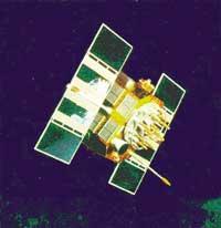
GPS -Global Positioning System- is the constellation of 24 orbiting satellites of the United States Department of Defense. Anyone who owns a private property and has a device that can receive GPS signals can use the service of these satellites for free. However, as you will see later, the U.S. military collects data more accurately than anyone else.
Thanks to the signals permanently sent by the GPS satellites, the GPS system shows the position of anything or anything on the Earth's surface. From these signals, and through triangulation, so three signals from three satellites will be needed, approximate position data can be obtained.
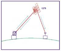
But how can the position be fixed from the signals emitted by these satellites? In order to obtain data on the position of the satellites it is necessary to know at all times the distance in each of them. This is achieved by measuring the time, that is, by measuring the time it takes for the signal to be sent from the satellite to reach the receiver. This can be done thanks to the code sent by each satellite, the pseudo-random code, since each satellite has its code. For example, the satellite code A is emitted from both the Earth and the satellite. If this code is detected in the ground, two versions of it are collected: The one sent from Earth and the one who sends the satellite. Of course, the latter comes a little later. If this delay is measured accurately, the distance to the satellite is obtained, since the speed of this signal is practically equal to the speed of light. Yes, for the system to have value, to accurately measure the time must be well synchronized.
The pseudorandom code is relatively complex and has advantages: 1) It is difficult to confuse the signal of a GPS with that of another GPS. 2) Interference is more difficult to produce. 3) The signal can increase considerably, so to receive it large satellite antennas are not necessary, any receiver can be worth.

With the theme of synchronization the satellites have no problem, as they are equipped with highly accurate atomic clocks. But what about the Earth's cheap receivers? Obviously, they have no atomic clock, because otherwise they would be very expensive. To solve the problem is a reading of the signal of the fourth satellite that can detect measurement failures. If the measurement of the time it takes for the signal of the three initial satellites to be error-free, the measurement to the fourth satellite should give the same reading. But as errors occur -gap between satellite codes and receivers - the signal coming from the fourth satellite indicates an incorrect measurement. This will allow the receiver to measure the error and make a more accurate reading.
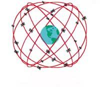
Therefore, precision is obtained according to the accuracy of the atomic clocks of GPS satellites, the satellites in orbit. In orbit… but where? In theory, at 20,200 kilometers of height. But at all times, where? To make things easier, GPS satellites are located in a very precise orbit, out of the atmosphere. Thus, since there is no friction with the atmosphere, there is no high risk of satellite movement. GPS receivers always have a tool to locate each satellite. However, due to the gravity of the Moon, the radiation of the Sun, etc., small errors occur, but they are well controlled by the U.S. Department of Defense.
The control between them is not limited to that, since the pseudo-random code sent by the satellite indicates exactly where the satellite is. Ground radars responsible for controlling satellites send this information to each satellite. Although everything seems to be under control, problems can arise and even arise:
- Theoretically, signals coming from the satellite to the receiver arrive through the speed of light and vacuum, while in reality the signal must traverse atmospheric layers in which the direction of the signal can be diverted, delayed and attenuated. To solve it it is possible to model the layer that crosses the signal, but the modeling will be mathematical and standard and the atmosphere is constantly changing. Another solution is dual-band technology, i.e. sending two different frequency signals for more precise measurement. However, this technology only depends on the most sophisticated receivers.
- Before reaching the receiver the signal can be found with buildings, power cables, etc., which can cause measurement errors. However, the latest receivers have a system that separates the most accurate signal.
- The satellite, although very precise, can present small position errors and the atomic clock itself.
- Satellites visible at all times must be selected correctly. If the satellites chosen for the position are far away from each other, the measurement is usually more accurate, while when closer the measurement is less accurate. The point is that you cannot always choose the most distant satellites.
- The military has the possibility to introduce errors in the signal. In times of war they can worsen signal quality and thus control technology. The military has the key to degeneration, so they can get more precision.
As the GPS system is from the United States, many countries are preparing their system. The Russians already have theirs -GLONASS- and the European Space Agency is working on a similar project.
Published in 7

Gai honi buruzko eduki gehiago
Elhuyarrek garatutako teknologia