


Road Maze
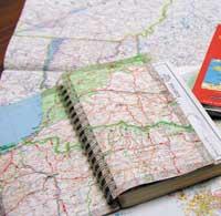
There are maps of different sizes, precisions, colors, information and scales. Depending on the trip you want to make, you will choose a map in which hostels and spectacular areas are located, or a smaller road, or mountain tours, etc.
In general, two types of maps are distinguished: topographic maps that offer an exact representation of a given terrain, and specialized or thematic maps that show all kinds of quantitative and qualitative phenomena.
However, the first steps to complete all these maps are similar, although there are several techniques. The oldest technique is based on local topographical measurements, but like other areas, cartography has been driven by technological advances.
Cartographers are currently based on photographs taken from planes for maps or satellite images. In this way, and to congratulate the traveller with little orientation, all maps are easily updated. In that sense, at least, there is no excuse to get lost.
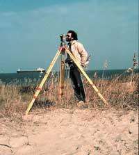
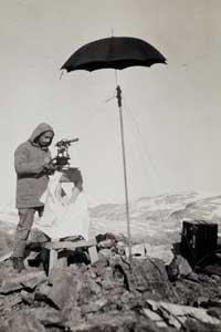
Topography suitable for small areas
The topography is based on measurements of angles and distances for representation on land paper. The first function of the topographer is to place in the plane the known points, that is, the geodesic vertices. Then, measuring distances and angles, you need to place the rest of the points according to those points.
Of course, it is a time-consuming technique that also has a degree of error depending on the material and the accuracy of the topographer. Therefore, topography is currently used to measure private areas, public works and, in general, large-scale measurements. It is also topographers who select the additional information that will appear on the map.
For the realization of maps at scale less than 1/20,000, that is, for the appearance of larger territorial areas, it is more common to rely on photographs taken from the plane or images taken via satellite.
Photogrammetry: maps based on aerial photographs
The photogrammetry is based on photographs taken from the plane to make maps. Of course, the photos are not done in any way, the plane follows a specific route and the camera used is automatic.
It is very important that the plane flies at constant height and does these photos with maximum precision. Thanks to these photographs will be deduced, among other things, the scale and the relief.
The scale depends on the focal length of the camera lens and the height of the plane when taking the photo. And the smaller the scale, the larger the plot that appears. For example, if the scale is 1/25,000, one centimeter on paper represents 250 meters. The
relief is also related to the accuracy of the photographs. In fact, if the photographed terrain is flat it is not necessary to deduce the relief, but what happens in the mountainous areas? If you take the photos with the vertical axis compared to the ground, how do you deduct the height of the summits?
It has a lot to do with the similarity between two consecutive photos. It is no coincidence that they are very similar in two photos. Normally, the difference from one photo to another is only a third of the land you photograph.
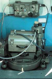
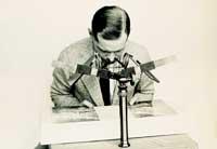
The puzzle consists of overlapping photographs and deduces the height of each point of the ground. To do this, the technicians are based on the principles of stereogrammetry and it is said that two consecutive photographs form a stereoscopic pair.
Once all the photos are taken, the laboratory work begins. For starters, depending on the geodesic and level points, you must mark the reference points in the photo.
Then proceed to the restoration. That is, it is time to complete maps from the photos and, among other things, to specify the relief. This is based on the principles of biocular vision or stereoscopy.
Therefore, the most complicated work is done. However, since the document obtained or stereodetailed is a mute map, surveyors who will act on the ground must complete it.
It is also said that these photos are traps, dark and mute. In fact, it is easy to confuse a pile of straw with a shack, it is impossible to see the forest roads and tunnels and do not appear the pedestrian paths of the mountains or administrative limitations.
Satellites also in cartography
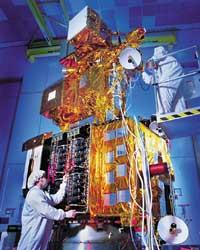
The new cartography comes from replacing satellite images with photographs of planes. This occurred when the American satellite Landsat, put into orbit in 1970, offered a new vision of the Earth. In addition, the digital model and geographic information systems (GIS) have contributed significantly to cartography.
Permanent satellite images allow you to update maps with great ease and accuracy. In addition, the evolution of vegetation, industrial development, new roads... everything is measured and controlled thanks to satellite images.
One of the major contributions of satellites to cartography has been to provide highly accurate information. To do this, the Earth is represented by radiations of different wavelengths.
To deduce the relief of the Earth are based both on the flow of radar and laser waves. That is, the satellite measures the flow of the waves reflected on the earth's surface. It is evident that the higher the relief, the faster the path of the satellite wave terra-satellite. In order to carry out this technique, the satellites are equipped with radars and laser.
One of the main differences between radar and laser is evident in ocean studies. Radars emit radio waves that, being not very penetrating, reflect the surfaces of the sea. In lasers, on the contrary, very penetrating waves are used that are not reflected until touching the background. Thus, it is advisable to use the radar to measure the fluctuations of the tides, but for the moment the only means to know the relief of the seabed is the laser.
Looking ahead
Aerial photos, satellite information, local measurements… there is more and more information in the hands of surveyors and geologists, but to advance the cartography is not enough to have more information. In addition to the elaboration of detailed maps and their easy updating, all this information must be available and organized for an adequate planning of the territory.
Geographic information systems are currently an indispensable source of information for professionals working in these areas. These systems consist of a series of data detected in space that contain information about terrestrial areas. They are very useful to update information on areas that are repeated and thus guide the proper management of the territory.
In addition to reporting on geology, climate, agriculture, water, etc., these data intersect. This allows, for example, to know in advance the impact of the construction of a new shopping center in each of these areas.
Cartography has gone from being a simple representation of space to new challenges. In this sense, an important future project is the electronic atlas of roads. This atlas will draw, depending on the vehicle, the shortest, fastest or cheapest route between two points.
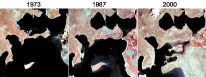
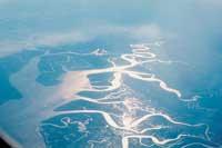
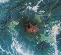
In the picture you can see the incredible change of the Aral Sea.
Stereogram principle
Maps based on photographs taken from planes are based on stereoscopy.
To understand what this technique is, let's think that we have taken pictures around Mount Larrun and that the top of the mountain appears in two consecutive photos. As the plane has advanced in its journey, the top is presented from different perspectives.
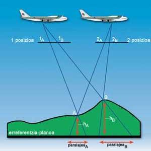
Now let's draw a straight line from the first and second positions of the plane to the top. The height of the top depends on the distance between the two points where these lines meet the terrain, which is called parallax. Greater parallax greater relief (see diagram).
Of course, to be based on this principle it is essential to know the distance between the photos and the flight of the plane at constant height.
Let us not think, however, that surveyors and technicians calculate the height point by point. Complex devices based on these principles are used for this purpose.
Buletina
Bidali zure helbide elektronikoa eta jaso asteroko buletina zure sarrera-ontzian


