
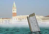
Zero meters above sea level
2009/03/01 Roa Zubia, Guillermo - Elhuyar Zientzia Iturria: Elhuyar aldizkaria
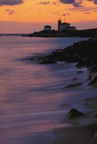
If there were no moon and the Earth did not move, the sea would be in balance, standing. The situation would be optimal to define the sea level and use it as a reference of heights. But around the Earth there is a moon, and the Earth moves, not only around the Sun and around the axis of rotation, but also from within, with the activity of tectonic plates. All these things put the sea to dance. It is not in balance. And, therefore, there is no sea level. And it is not possible to determine zero altitude targets.
Zero of the tide
It gives equal. The sea was one of the best references to the reach of the human being and, as it is below, defined a sea level. Each people defined one. He chose a point with small tides where he put the zero height reference.
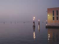
We had to take into account the tides, which went up and down twice a day. Great change in a short time. In some places, in addition, there were great changes. The world's liveliest tides have an incidence of 11.7 meters on the east coast of Canada, in Nova Scotia. They have been measured 9.2 meters in the Bristol Estuary and 8.6 meters in Mount St. Michel, in French Normandy. The usual live tides in Euskal Herria range from 4 to 5 meters. Precisely, places with this type of tides were the most inadequate to define the level of the sea. They moved away from these places and searched for small tides.
And although they chose the places of the small tide, not all peoples made the same decision. In some villages the zero was put in the lowest tide point, as in the Belgian city of Ostend. Others put it at the highest point of these small tides; in Holland, for example, the reference was placed in Amsterdam, in the middle point of height of all the pleamares of the year 1684, according to a mark made in the town hall.

Middle tide
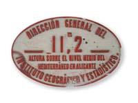
In other places, they have not chosen the low tide or the pleamar, but the average of both tides. In Spain the Mediterranean is used to put to zero the level of the sea in the city of Alicante. In 1870 the decision was made and on the access stairs to the city council, on the third level, a bronze disc was placed in memory of the decision. In France there is also the reference in the Mediterranean, in Marseille. In Italy, in Geneva, and the reference of Croatia in the Italian Trieste.
In some cases, they have modified an adopted reference point. In the case of England, for example, they took the reference in Liverpool in 1844, on the west coast of the island, but in XX. In the first quarter of the century it was transferred to the channel of La Mancha. From May 1915 to April 1921 he referred to the average height of the tides of the city of Newlyn and since then he is in the city of Cornwall.
The case of Argentina is more surprising. The zero of the height was placed in the city of Mar del Plata in 1924, and twenty years later the reference was moved to the city of Tandil. The reason was that Tandil's reference is more stable. The most surprising thing is that Tandil is located 200 kilometers from the coast.
Municipalities without coast
All coastal towns find a place conducive to putting zero in height. In Europe, for example: Lisbon in Portugal, Belgium Ostend, Ireland cape Malin Head (the northernmost point on the island), Denmark Aarhus, Finland Helsinki, Russia Kronstadt (next to St Petersburg), etc. In some great peoples of the world, such as the United States or India, they have two main coasts, with references in two places.
But the villages without coast also need a reference. And in these villages the sea is still the reference. They normally use the same zero as a coastal town. In Switzerland, for example, they use the French zero, that of Marseilles; in Lake Leman, in Geneva, in a stone called Pierre de Niton, they have placed a mark of 370 meters high.
Earth above
The problems that the reference to height has to measure are not only a consequence of the fluctuations of the sea. Geological activity also moves the land. In Scandinavia, for example, the movement of the earth has caused a problem. On the outer coast of the peninsula the land level does not move, but on the Gulf of Botnia, between Sweden and Finland.
At a point close to the city of Ornskoldsvik, the land is climbing 8 millimeters a year as if a finger pushed through the underground. The movement of the Earth itself and its different speed in each place make it very difficult to define a zero as a reference of heights.
Mathematical solution
Each people has their problem according to their characteristics, so each people must seek their solution. However, the exact measurement of heights is, basically, a mathematical problem. In short, height is the distance measured vertically above a surface, and the problem is to define it properly.
The surface, moreover, is not a plane. It cannot be because the Earth is not flat. The definition of the plane can work in very small territories - if we had to take a reference for the Basque Country for example-, but it would not be a concrete solution. The surface of the Earth, and therefore, the hypothetical level of the sea, is zero. It is a surface similar to a sphere, but it is not a sphere. In reality it is a geoid
Normally, to work with the sea level an ellipsoid is chosen, since it is a good approximation to the geoid. And to work with ellipsoid, surveyors define a mathematical model called datum.

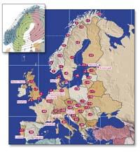
Each locality, in addition to defining the point of reference of zero, defines a datum for the management of heights. And in recent years, in addition, we are working on unifying references. If there was a single datum valid for the entire planet, the system of references of heights would be obsolete and the problem would be solved. There would be only one reference for the whole planet.
But that convergence is very difficult. In Europe, for example, in the last two decades, we have worked on this path. Since the Berlin Wall was demolished in 1989 and the dismantling of the communist bloc, they try to unify it.
Arch of the earth
Despite being the smallest of the continents, Europe is large. From Lisbon to Moscow there are 3,900 kilometers, distance that takes the arc corresponding to an angle of 35 degrees in the ellipsoid defined. And, therefore, the angle formed by a height defined in Lisbon and another defined in Moscow should be 35 degrees, but it should not be so too.
There are several ways to measure heights. Once the ellipsoid is defined, they can be measured in a line perpendicular to this ellipsoid, which are orthogic heights. However, in practice, the direction to measure height is marked by lead lead lead, a direction that is not always totally vertical, since the zone of gravity is not totally regular in all places, to which the lead is marked is called normal height.
Of course, to take a reference system of normal heights, it is necessary to accurately measure gravity. Create a thorough record of all irregularities and perform a new datum. They do so through satellites. This is a great work, but nowadays there are peoples who use normal heights in the reference system. Also those using orthographic heights and a combination of both.
Convergence is a very difficult issue, involving many factors, peoples, traditions and political situations. But it may be a unified system, at least in Europe. For the moment, from the villages with more similar systems, a unified datum has been developed up to a height limit. Defined in the year 2000. In that datum, 50 centimeters below what should be the Spanish reference, 49 centimeters below France, one centimeter above Germany, etc. The consolidation effort advances.

Gai honi buruzko eduki gehiago
Elhuyarrek garatutako teknologia