


A system that improves the work of agents
In this line, and taking advantage of the technological advances, a team of the Faculty of Computer Science of San Sebastian has presented the project GPSApp so that the agents of the Municipal Guard perform their work better. The GPSApp project was created for the management, planning and control of the routes of the municipal agents of the Amorebieta-Etxano City Council. At present, in most places the patrols are not controlled, so it is possible that some neighborhoods or places of the municipality do not pass through them or that the service is not very adequate in all areas of the municipality. For this reason, they have created a tool to control the management of patrols.
This application allows the City Council to have a system of control of routes. This system is based on GPS technology and combines PDA (Personal Digital Assistant) and real-time data transmission. Each patrol has a PDA and a GPS and records why the patrol has passed. These data are sent to the central administration through wireless communications (mobile phones, radio frequency...), where agents' movements are controlled.
It is also possible to automate other processes such as the collection of complaints: when a patrol has to make a complaint or notify an event, the data is entered in the PDA and these, like the GPS data, are sent to the central administration. In this way, all necessary procedures are started immediately, the accumulation of tasks is avoided and the working conditions of the agents are improved.
The two phases of the project
This project consists of two phases. The first is based on the localization system. This system allows to know with precision and reliability the route made by a group of local police.
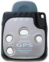
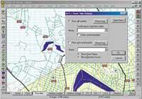
For this purpose, each patrol is given a GPS that records all the points through which the Municipal Guard passes and accumulates information. Once the route is finished, the GPS data is passed to a computer thanks to a computer application and the path, points of interest and other parameters are represented in a geographical map. The same app also includes information about the patrol's performance and events.
In a second phase, the use of the PDA has been analyzed in order to facilitate the work of municipal agents. These laptops have a touch screen that allows the user to press the buttons, activate the menu or write by a pen. This small tool fulfills the same functions as a computer: among other things, you can write a document, write and read emails and watch some short videos. Each patrol has a tool of this type.
Each PDA has an additional GPS to record the route, allowing to record notices, complaints and other actions without using paper. All these data are downloaded at the end of the patrol tour.
The real-time data transmission system has also been studied through the mobile phone (GSM, GPRS, or UMTS) or via radio frequency and using an exclusive radio channel so that they can access the data before the end of the day.
For the City Council of Amorebieta-Etxano this project has several objectives, among which is the improvement of the working conditions of the municipal agents in terms of efficiency, performance and security, local patrols must visit more spaces and, in short, be able to better control all their functions.
The system used in the GPSApp project is progressive in its field. In fact, until recently the GPS technology did not serve for this type of applications. In urban areas this system presented numerous errors. The researchers of the Faculty of Computer Science of San Sebastian have managed to deal with these problems and have developed the system to their liking.

In addition, the aim of this project is not to solve the management problems of the final client, but to create a flexible platform for future applications. Comparing the proposed system with other solutions based on mobile telephony, it is not expensive, so it may interest other types of customers. The hardware and software used are standard and easily accessible. Both elements ensure compatibility. In addition, the certainty and measures to be taken in case of the fault of the system have been taken into account. With all this, they have defined the project as an open and adaptable platform that serves different functions.
www.ihobe.net
Buletina
Bidali zure helbide elektronikoa eta jaso asteroko buletina zure sarrera-ontzian


