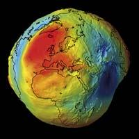

Map of world gravity
2011/04/07 Roa Zubia, Guillermo - Elhuyar Zientzia
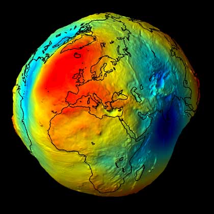
Using the GOCE satellite measures of the European agency ESA, scientists have developed the most accurate map of Earth's gravity. The result is a geoid, that is, the form that the Earth would have if in that aspect only gravity would influence. That is why they have made accurate measurements of the gravity of the Earth. The GOCE satellite has been collecting data for two years, with a total of 70 million data. For this purpose, it has used six high sensitivity accelerometers, which measure acceleration and therefore gravity.
What is seen in the image is based on this appearance, but the incidences of gravity are greatly increased. The areas of lesser gravity are represented in yellow and those of greater gravity in blue.
In this data there is a lot of information. Experts of the ESA, for example, have highlighted that the data reveal the distribution of the matter inside the Earth, very important in seismology, since earthquakes leave a mark on the map of gravity. On the other hand, the map allows to analyze ocean traffic and many other characteristics.
Image: Image: ESA ESA

Gai honi buruzko eduki gehiago
Elhuyarrek garatutako teknologia