


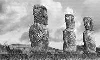
The Moaien Journey
To date archaeologists have formulated numerous hypotheses, but at the moment there is no reliable theory about the Moai of Batz Island. The University of California Department of Archaeology has been investigating the spectacular monuments of Baz Island for five years. The study focused on the transport system used to move the docks. After analyzing the dimensions of the moayas and the topography of the Island of Baz, it was possible to know the system used and the roads by the inhabitants of the area, Rapa Nui.
The analysis starts from the three-dimensional map of Baz Island. Using virtual reality, they have captured the geographical characteristics of the island and have taken advantage of the localization system used by current robots to renew the path traveled by Rapa Nui. The second objective of the research has been to unravel how the distance from the coast to the plot where the waiters are located. To do this they have classified the energy necessary to transport the moaia, the force that generates friction and the geographical characteristics of the Island.
From there the work has been done by the computer using the programs used for the robot transport system. According to the researchers, the possible route that the computer has launched perfectly meets the conditions that Rapa Nui had taken into account for the transport of the docks. Just renovating the route that the computer defined on the Island of Baz, they realized that on the way there were still remains of fashion. It seems that they have fully succeeded.
Buletina
Bidali zure helbide elektronikoa eta jaso asteroko buletina zure sarrera-ontzian


