
Launch time for Envisat
2002/02/28 Mendiburu, Joana - Elhuyar Zientziaren Komunikazioa
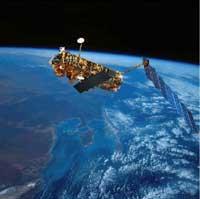
Envisat is the largest and most complex satellite of the fully equipped ESA. It has a length of 25 meters and a width of ten meters and a weight of more than eight tons. Its function will be to collect and send environmental data, for which it has various tools.
The program is expected to be underway for 15 years and the construction, launch and five years of satellite in space will cost 2.3 million euros. The cost is high, but ESA officials have recalled that climate change and the rest of the environmental problems are everyone's responsibility and therefore have not made budget cuts. In other words, the Envisat program will cost each European as much as a coffee per year.
How many data, different tools
The functions to be performed will be those of expenditure. It will include information on the greenhouse effect, the destruction of the ozone layer and climate change over the next five years, among others. According to ESA officials, information will be critical to making policy decisions on climate change.
To join this data, the Envisat satellite has several tools.
Thanks to the images sent by the radar Advanced Synthetic Aperture Radar (ASAR), you can also predict the minor variations of the terrestrial surface. This instrument, in a single transit, is able to design the map of the earth's surface with a resolution of about ten meters and, in addition, the atmospheric conditions do not condition its work. This will allow for artificial and natural disasters. For example, the explosion of a volcano can be predicted, even when the first movements are a few centimeters.
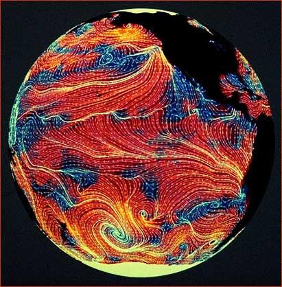
The Global Ozone Monitoring by Occultation of Stars (GOMOS) detector will determine the distribution of ozone around the planet. Thanks to the general three-dimensional maps MIPAS and SCIAMACHY, all gases in the atmosphere will be known. Most accurately, greenhouse gases such as methane and carbon monoxide will be measured. It is known that each year, in early August and September, ozone levels in the Antarctic high atmosphere are drastically reduced. In a chain of chemical reactions, chlorine atoms, mainly from CFC gases, eliminate ozone on a large scale. Consequently, part of the planet is unprotected from ultraviolet radiation. The information sent by GOMOS will serve to better understand this fact. The detector will be able, on a very small scale, to communicate ozone levels anywhere in the world.
Advanced Along Track Scanning Radiometer (AATSR) will measure the exact sea surface temperature and the Medium Resolution Imaging Specrometer Technology (MERIS) will reveal the ocean color. The distribution of colors will allow to know the distribution of phytoplankton. Phytoplankton is an absorbent of biosphere carbon dioxide, so this information will measure climate change. On the other hand, the radar altimeter will measure the minor changes in sea level and the topography of polar ice. This data will be precious to forecast meteorological phenomena like the Child. In fact, before El Niño, extraordinary elevations of temperature occur at sea and on land, increasing the sea level by about 50 centimeters. The radar altimeter can detect this variation in sea level.
It is clear, therefore, that meteorologists and other experts will receive precious information from Envisat. Another issue is whether politicians will take all of this data into account to take action on climate change.

Gai honi buruzko eduki gehiago
Elhuyarrek garatutako teknologia