


Collaborating better than alone
The European Space Agency has begun to resolve some doubts. Researchers who defended that using the ERS-1 and ERS-2 satellites together was throwing money in vain have had to yield.
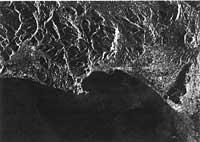
In the following figure you can see the details of the Italian coast. This three-dimensional image has been obtained using simultaneously the information transmitted by the two satellites and the researchers have stated that this joint use has facilitated the understanding of the data transmitted by the satellites. Satellites simultaneously receive and broadcast images taken on different days at the same time. This allows to analyze directly the concrete evolution of the phenomenon that is intended to investigate, without waiting for the next research project.
Buletina
Bidali zure helbide elektronikoa eta jaso asteroko buletina zure sarrera-ontzian


