


The storm comes!
The most destructive storms occur in the tropics. In television news reports we often see images of storms of this type: the wind bursts palm trees and pulls houses out of the ass, torrential rains cause flooding and the sea attacks the coast. They are tropical storms.
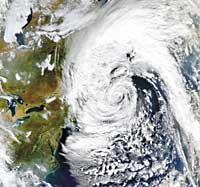
Even if these storms are violent, they can take more force and become cyclones. Cyclones, hurricanes, typhoons... there are countless ways to call the same weather phenomenon. Hurricanes take place in the Atlantic Ocean, the Caribbean and the Gulf of Mexico. Typhoons are from Southeast Asia. Tropical cyclones in the Indian Ocean. And in Australia they are known as wiky-wiky.
In each place it has a name, but that does not reverse this phenomenon. Basically these are strong winds over 155 km/h that can feed, increase and strengthen the warm waters of the sea. Cyclones occur at sea. As the warm water warms the air from the surface, the air rises to form a whirlpool. This swirl grows to 250 km in diameter.
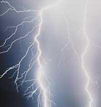
every sense of the word. The rays illuminate the dark sky during a storm. They are electric shocks that cross the sky. Sometimes they occur inside storm clouds, others instead move from one cloud to another and often touch the earth. If so, it is preferable to protect yourself in a safe place if a
150 million volt shake is not desired.
Regardless of the extension of the whirlpool, in the center is a quiet area called eye, a low pressure area. But that tranquility is quite false because the strongest winds are around the eye, that is, on the walls of the eye. Therefore, for a better knowledge of cyclones, this eye and the surrounding wall are investigated.
Surprisingly, planes are used to investigate the eye of the hurricane. There are more and more remote guided planes, but there are also manned missions that reach the center of the hurricane. These missions are carried out mainly when the cyclone has not yet reached the coast. The data collected in the eye itself joins those obtained by satellites and tries to predict where the cyclone will go to the coast and how it will evolve.
Information received by satellites is also used for predictions. The most well-known satellites in Europe are ESA's Meteosat-6 and Meteosat-7 and, of course, Meteosat-8, a second-generation satellite. NASA uses the Terra and Aqua satellites. And China, India and Japan also have weather satellites in orbit.
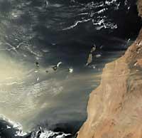
the Canary Islands The cold wind blows from Europe to the west of Africa. This wind raises the remains of the Sahara desert and dust reaches the Atlantic coast. In these cases, Saharawi dust also reaches the Canary Islands. But the dust and sand particles do not stay, the wind force introduces them into the ocean.
Satellites include equipment to measure atmospheric precipitation and wind direction. And of course, they also make photos that are used to predict the time of the next few days.
But cyclones are more than rain and wind. When they approach the ground they can form tornadoes around it, which causes more damage, in addition to the disaster caused by the cyclone itself. Nor should we forget the rays, one of the parameters used to study the force and evolution of cyclones is that of the rays.
The rays increase with the storm. This is why lightning frequency is monitored. With this data, together with rainfall flow, wind environment, etc., more reliable short-term weather forecasts are sought. Thus, the inhabitants of the tropics can be warned in advance when the storm or cyclone arrives. Weather forecasts are also made around the world and extensive monitoring of electric and sand storms is carried out.

the moment a cyclone occurs in the sea is monitored. The objective is to collect as many data as possible to know if it will reach the coast and, if applicable, with what force it will arrive. In the satellites the rainfall data are taken on the one hand and those corresponding to the force and direction of the wind on the other. These measurements are carried out by means of precipitation radars, sensors, eschatometers, etc. And unifying it, you get spectacular maps of this type.
And the fact is that in the non-tropical regions there are also sharp storms. The sand storms in the deserts are dramatic: a sudden burst of wind raises the remains and, after shaking everything it catches, the sands are covered by every corner. Something similar happens at the poles, since the wind hardly has obstacles in its passage and strongly shaken these territories.
Finally, the regions between the tropics and the poles are not safe from storms either: they can suffer thunderstorms or ice storms, among others.
These natural phenomena cannot be opposed, although efforts are not lacking. Despite human forces, it will never get storms to cause damage. They cause death and serious economic damage. But, at least, if predictions are made on time, people can protect themselves before the storm comes.
Tsunamis
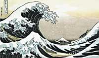
One of the effects of cyclones is the desconchamiento of the sea, and if it is accompanied by the pleamar, the spectacular waves will attack the coast. But these waves do not quench tsunamis. Tsunamis are also known as giant waves, not in vain! They can reach 50 meters in height and, on one occasion, destroy and eliminate a coastal village.
The tsunami is due to sudden agitation. The causative agent may be the eruption of a volcano on an island, an earthquake on the coast or inside the ocean, or the impact of a large object, such as a meteorite or a piece of coastal land that has moved to the sea. Waves caused by agitation spread in the ocean, often in thousands of kilometers. But they are very difficult to detect, as they do not usually have great heights. They usually have very large wavelengths – there may be an hour of difference between one wave and the next. Arriving at the coast, however, as the depth of the water decreases, the wave is gaining height and strongly shaking the coast.
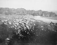
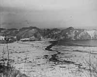
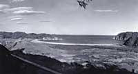
Taro (Japan) The
Japanese know tsunamis quite well. Not in vain, the term used worldwide to designate these giant waves comes from Japanese. Tsunami, in Japanese, means ‘port wave’.
Volcanic eruptions and earthquakes are relatively frequent on the western Pacific coast, so tsunamis have long shaken Japan and the adjacent islands.
In the picture, Taro is a fishing village. Before (above) and after (in the middle) the tsunami attack. In 1933, when the reconstruction of the village began, a wall of protection against the giant waves (below) was built.
Buletina
Bidali zure helbide elektronikoa eta jaso asteroko buletina zure sarrera-ontzian


