Live weather on TV
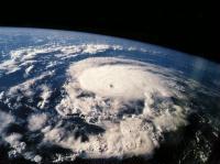
Next year, Mississippi's Astro Vision Inc. will launch the first of a group of small satellites into space. These small satellites will offer live color images of the fronts of storms, hurricanes, forest fires and some natural disasters. This project is being attended by NASA technicians who expect researchers to use all of this data. In addition, it can be a source to start meeting the need for data on the Internet.
According to the latest issue of Science magazine, the $65 million collection work needed to launch the first step will conclude this week. In this step the Avstar 1 satellite will be put into orbit in October 2001 and six months later, another like the previous one.
Outstanding revenue
Another economic contribution will be the acquisition by NASA of US$9.4 million information on tornado creation. However, the highest income for the company will be the public following the Weather Channel and the one that opens the NOAA (National Oceanic and Atmospheric Administration) website on the Internet. In the words of one of Michael Hewins' leaders, "we will change the way we see Earth's Meteorology and Environment." NASA's opinion does not go so far. "It's a careful project with a lot of resources to get ahead," says David Brannon of the Stennis Space Center. Bramon has worked for 3 years with Astro Vision.
The cost of each Avstar satellite is 20-25 million dollars, including launch costs. It has two cameras, the first one is of great angle and has a precision of 7 kilometers, and the second one of smaller angle but with a resolution of half a kilometer. This resolution is low compared to the military spy satellites, but they have the accuracy of others already used and can be considered as sufficient for observing time.
The Astro Vision team will send the image every minute. Keep in mind that US government satellites send the image at least every fifteen minutes and sometimes half an hour. Thus, Astro Vision aims to obtain videos of the creation of storms and hurricanes and the dispersion of fires. As soon as volcanic eruptions occur, they will announce and know the width of the fires. Satellites will be shot every six months in the second step of the project. The separation of these satellites will be 100 meters. Finally, thanks to the set of satellites you can see everything at once.
Government satellite system
Fritz Hasler, a meteorologist at NASA's Goddard Space Flight Center, says this project will allow meteorologists greater flexibility in the current offer. The current GOES (Geostationary Operational Environmental Satellites) satellites must choose between the global vision of the Earth and the rapid scans in small territories. "In general we only have to follow one of the two methods," says goes technician Raymond Steiner. In addition, since goes is used by many researchers, there is no possibility of performing specific scans of what each one wants. If the NOAA had a new satellite, they would use it for small quick scans but have no money for it.
In addition, the vision of the Astro Vision satellites will be narrower than that of the goes, with a resolution of half a kilometer over a kilometer. In Brannon's view, the upper parts of storms that can form chimney shaped clouds can be accurately observed. This means that they can be predicted 15 minutes before the creation of tornadoes. The project provides the use of private companies. Ghassem Asrar, head of NASA's Office of Earth Science, said Astro Vision has cost them more than buying data, developing new satellites, making them and throwing them.
However, there are those who defend the GOES system. Meteorologist Dennis McCarthy claims that combining the goes imaging system and Doppler effect radar, sometimes tornado formation predicts quickly and scans per minute also offer storm evolution. Despite large incomes, Astro Vision's goal is not just data collection for the government. It is a company dedicated to the realization of sales videos, leisure products. And they say that at least two-thirds of their production will go to the media, and that internet companies are also involved. According to the company, it can be an example of science for leisure.
Buletina
Bidali zure helbide elektronikoa eta jaso asteroko buletina zure sarrera-ontzian