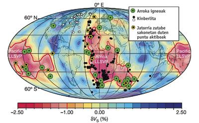
Location map of diamonds

An international geophysical team has created a map that can help predict the location of diamonds around the world. This is a first image of this type that has been elaborated taking into account both the surface geological processes of the Earth and the inner background dynamics of the planet.
According to the geophysics of the University of Oslo, in addition to being a useful tool for finding diamonds, this image will offer scientists interesting information about the functioning of our planet.
The researchers have confirmed that the location of diamonds on the terrestrial surface depends on the columns that rise through the mantle. That is, diamonds are formed in situations of high pressure, in the mantle of the Earth, more than 150 kilometers deep. They bloom like quinberlites (volcanic diamond rocks). Thus, the geophysicists affirm that knowing where the feathers or columns that rise from the mantle are, one can know where most quinberlite - and diamond - are found.
To reach this conclusion, the research has focused on the oldest continental zones of the terrestrial surface and has rebuilt the position of tectonic plates in the last 540 million years. Thus, they have found that 80% of the quinberlites emerged in the area where the columns were formed. As seen on the map, one of these areas is located in Africa, rich in diamonds.
Buletina
Bidali zure helbide elektronikoa eta jaso asteroko buletina zure sarrera-ontzian


