


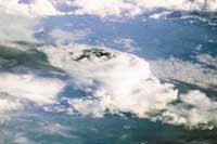
View from space?
The numbers seem to indicate that astronauts like more to photograph than Japanese tourists. More than 400.000 have already been released. The 85% of the photographs correspond to the Earth, while the rest show the work done by astronauts outside the vehicles or inside the cabin.
They have not taken so many photos during the two years of operation of the International Space Station (NEE). In the early 1960s, American astronauts began photographing the Earth alongside the Mercury missions. As soon as possible, the Mercury missions were the first ones led by NASA.
Today, the International Space Station is the main photographic source. In fact, one of the duties of astronauts working on it is to take photos. This work, mission or project is called Crew Earth Observation and is managed by NASA's Johnson space center. From there all astronauts are managed, not only the Americans. Photos are available free of charge on the internet at http://eol.jsc.nasa.gov/sseop/.
Photography is an investigation
The earth has to be special from the 350 kilometers and the astronauts will enjoy that vision, but photography is a work first of all. For this reason, photography is one of the subjects of the training program. Photography and geology, ecology, geography, meteorology, oceanography... They have to learn everything and then be able to distinguish what they are seeing from space. They usually train to look for unusual things, such as sunlight, the reflected light in the ocean shows marine currents and islands that are not seen otherwise. This ability to see extraordinary events brings added value to the work done by astronauts. Added value regarding the work performed by satellites.
Today, satellites are the most used to photograph the Earth, but satellites are machines and are controlled at a distance. Therefore, despite being good in the execution of the planned works, they offer few possibilities of improvisation. Astronauts, on the other hand, can improvise everything they want and take a photo when they call their attention. They can take advantage of the premieres between clouds, quickly change the objectives of the machine, and track the spatial or terrestrial curiosities.
In addition to the capacity for quick reaction and improvisation, the pictures of astronauts are special because they can play with perspective. Most satellites are oriented downwards, that is, they observe the Earth without angles. Or with a fixed angle. Astronauts, on the other hand, only have to move their hands to change the angle between the camera and the Earth. And the angle is important for detecting certain atmospheric phenomena.
For example, the photographs that show the horizon show more concentrated aerosols and mists and make visible the dust that do not detect the sensors of the satellites. On the other hand, photographs taken at the horizon during sunrise or sunset allow us to observe atmospheric layers and detect variations.
These characteristics make the researchers greatly appreciate the pictures of astronauts and transmit dozens of requests every week. Astronauts improvise a lot, but improvisation is not law. As for the International Space Station, due to the limited time of astronauts during the construction phase, it has been decided to limit the research issues to seven: deltas, coral reefs, urban pollution, large floods and droughts, glaciers, faults in the limits of tectonic plates and unique geological formations such as the great craters.
With 10 minutes astronauts are usually enough to perform these works every day, although the older ones on Earth know that it gives them much more time looking out the window. But they do not because they know it is a good therapy to deal with closure, and an unexpected source of discovery.
In 1994, for example, the crew of the Columbia space shuttle saw a rare mist over the Caribbean Sea. They took pictures, sent them to Earth and received a surprising response: the mist was a gigantic cloud of dust from Africa. Until then, no one thought that dust clouds could cross the Atlantic Ocean, and when they were thin clouds, satellites never detected them.
Since then, it has been discovered that sandstorms in the Sahara cause dust clouds to reach America every summer, along with microbes and allergens. And that these clouds are responsible for the red tide that kills in the Gulf of Mexico numerous fish, seafood, marine mammals and birds. Next to the dust, iron reaches the sea and, in these conditions, toxic algae multiply remarkably.
Graphic testimony of the years of human activity
Apart from the significant findings, the work of 30-year-old astronauts is very useful to see how human activity distorts the Earth, among other things because it gives the measure of urban growth and deforestation. Since many cities, coral reefs or glaciers have followed for years, it can be observed very graphically the variation of the Earth in the last 30 years.
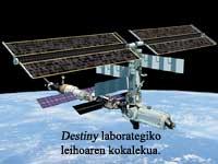
A good example is the delta of the Yellow River of China. The Yellow River has been transformed by man for thousands of years, but in the last thirteen years, due to the droughts, it barely reaches the water and has suffered big changes in size. From 1989 to 1995 it grew 400 square kilometers, then lost half of the area gained in two years and from 1997 it grew again 100 square kilometers. The Yellow River avatars have been followed for years from the space shuttle and for two years since the International Space Station. For this purpose, astronauts have a very special window at the top, the window of the Destiny module.
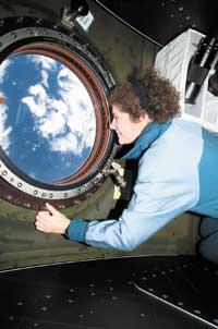
The Destiny module window, the most appreciated of all
The Destiny module was added by NASA in 2001. This is a module prepared for scientific research, but it is also the most appropriate place for leisure, since from there you can see the best views of the Earth. Astronauts say they can approach and go down to the window because it seems that the window has no glass.
The window, like that of the houses, is made of glass, but of the same quality as the lenses of the telescopes, that is, it transmits 98.5% of the visible light that touches on it, without distortions. This means that looking behind the crystal with a telescope, the stars look transparent. Through the window of the house, those who look good to the eye become blurred spots of colors from the telescope.
With this type of windows and great skill, astronauts have taken pictures of very good quality from the International Space Station. In some cases they have been able to make photographs with a resolution of between 6 and 8 meters, that is, separable from the buses.
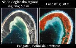
Commercial satellites, for their part, offer a resolution of between 10 and 25 meters that allows differentiating buildings and streets.
In any case, it is planned to use the Destiny window for something more than to take photos. In June of this year, with a year of delay, the structure called WORF, T he Windows Observational Research Facility will be launched. In short, the WORF is the infrastructure that allows to install sensors and computers in the window.
An infrastructure of this type allows to use in the space the sensors used in the Earth itself, since being inside the station, they should not be designed to deal with the harsh conditions of the space. In addition, the configuration of the instruments will be easily modifiable manually and, if necessary, its repair or calibration, will be sent to Earth. Working like this is much more comfortable and cost-effective than putting sensors into the satellites and controlling them remotely.
The WORF system will be used for the first time by students. In fact, within the ISS EarthKAM project, American mid-cycle students can control a camera installed in the Destiny window. They control the camera from the class and can take the photo they want to analyze it in class. The project began in 1996 with the ferry, then called Kidsat, and has been continued at the International Space Station. The photos of the students can be seen in http://www.earthkam.ucsd.edu.
Are those of space normal photos?
For what is seen, it cannot be said that they are normal, but the technical means are the same ones used on Earth. The International Space Station has video recorders such as terrestrial, digital cameras and 35 and 70 mm cameras. As for the films, most of the photographs are of color. In some missions color films have been used that detect infrared light and black and white have been made a few, but if not, those of normal colors.
Those who reveal films sent by astronauts to Earth extol the visibility and transparency of photographs. And it must not be forgotten that the space station moves very quickly around the Earth – which completes a turn in an hour and a half – and yet the photos do not come out moved. Astronauts work without triples, but, intentionally or unintentionally, they follow the movement of the Earth and make transparent photographs. In the best of cases they have managed to make photos with a resolution of between 6 and 8 meters, that is, a separable truck. However, its usual resolution is 30-80 meters, similar to that of the LANDSAT satellites.
Almost everything visible from the International Space Station
The International Space Station is located at an average distance of 354 kilometers and turns to Earth every 91-93 minutes. It has an inclination of 51.6 degrees. This means that you can see the terrain between these latitudes approximately. Within these limits is located 95% of the surface inhabited by man.
Studies of the International Space Station
- Deltas The coasts have changed drastically in a few years: barriers have been built to control the path of water and sedimentation, the population has increased significantly, underground waters have been extracted... The photographs of astronauts give dimension to these changes and complete other studies of dynamics of the coasts. From the International Space Station a special follow-up of the deltas of southern and eastern Asia is carried out.
- Some glaciers remain covered with ice throughout the year or depending on the season. The relationship between the dynamics of glaciers and the local climate is not understood exactly, but scientists believe that the loss of ice that has occurred in the last hundred years is related to climate change. The International Space Station analyzes the seasonal evolution of the world's glaciers, especially those of the Rocky Mountains, the highest peaks of the Ecuadorian regions and the Andes. It is also followed by the ice around the poles.
 Coral reefs 58% of the coral reefs are in danger due to human activities and the photographs taken from space are very useful to know the situation, extent and condition of the coral reefs. Astronauts are considered basic sources when mapping.
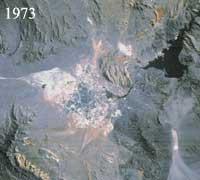
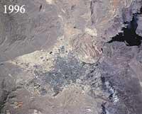 The evolution of the city of Las Vegas is reflected in the photographs taken by Astronauta. One of the photographs is Las Vegas. In 1973 it had an extension of 206km 2 and in 1996 of 628, representing an increase of 204%. The population increased from 273,000 to 1.1 million. (Photos: NASA (SKYLAB), SL3-28599 and Mir NM-725-34.
- Cities: growth and pollution is estimated at three fifths of the human population by 2030. Follow-up to the growth of large cities from the International Space Station. In parallel, the smog covering the horizon in many cities will be analyzed. Climatologists and meteorologists are very interested in these mists, formed by polluting substances, which besides being toxic, are responsible for local temperature changes.
- Droughts and floods from the International Space Station are investigated floods and droughts mainly related to the Child. The astronauts capture in the photos the fires, the drops of the water level, etc., indicators of drought. Or the banks that indicate an increase in floods and rains. The evolution of the territories most affected by El Ñino from the International Space Station during the years 1997-98 will be analyzed and the works carried out from the Mir station will continue.
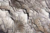
- From the International Space Station, the tectonic processes in East Africa are investigated. For geologists who study the formation of ocean bottoms and fractures of continental plates, the fault system of this region is very interesting, since its break is similar to that which in its day separated America, Eurasia and Africa. This rupture caused the birth of the Atlantic Ocean.
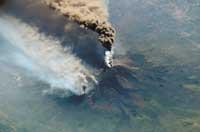
- Volcanic eruptions, hurricanes, floods... In addition to the planned projects, astronauts portray many unexpected events. Volcanic eruptions, sandstorms, hurricanes, floods, sudden proliferation of plankton... In addition, they can exploit regions in which there is no follow-up with other methods.
Everest from space
The astronaut Dan Bursch enjoyed last March. Waking up early, he decided to take a look at the world map and realized that in a short time they were going to pass over Mount Everest. In the computer the altitude of the space station was consulted, it was verified that it could open the window door and went to the camera window in hand. The morning sun allowed him to take this beautiful photo. He wrote in the newspaper and it seemed to him that Everest had to jump to it.
Buletina
Bidali zure helbide elektronikoa eta jaso asteroko buletina zure sarrera-ontzian


