
The hurricane season arrives
2003/07/30 Kortabarria Olabarria, Beñardo - Elhuyar Zientzia

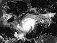
Hurricanes are, in short, giant storms of wind. In general, in hurricanes the wind adopts a form of spiral that moves on the terrestrial surface. In most cases, hurricanes are an area of low atmospheric pressure, with a temperature higher than that of the environment. Although there are several ways to classify wind storms, they are more frequent depending on wind speed. Thus, tropical depression is spoken of when the wind is less than 65 kilometers per hour, of tropical storms when the speed reaches 110 kilometers per hour and hurricane above.
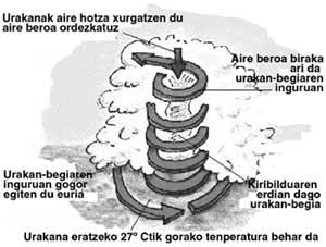
The hurricane can be assimilated to conventional steam machines, since the fuel is hot and humid air. When the princes of the Sun heat the sea water, the humid wind warms up, expands and begins to ascend as if it were a flying ball flowing with wind. Because the place of this wet wind that has gone up is covered by more wet winds coming down, the process is reset.
It does not seem difficult and, in fact, in nature there are many situations in which the hurricane can form. However, you really have to spend more than what is said in the previous lines.
For example, a high temperature is essential. Experts put the limit at 27 degrees. At this temperature, the sea water is supposed to evaporate at the speed necessary to initiate the hurricane process. This process of evaporation and its subsequent condensation, forming mists, liberate the strong winds and the energy necessary to produce the rain.
But the high temperature is not enough to form hurricanes. Humidity is also needed and as in the Tropics the temperature is usually high, there is no lack of humidity. And it is that the hurricane has to feed constantly, receive steam without faults. Therefore, on the sea, hurricanes have more strength because they are feeding and feeding, while when they reach the ground they weaken.
With high temperature and humidity, wind is needed. On the sea of the tropics is usual the hot wind. Thanks to this, a lot of water is evaporated and it is easy to ascend. In this way a negative pressure is generated. The pressure leads the wind inwards and upwards in the form of a spiral, which allows to repeat the evaporation process. In the high layers of the atmosphere, the wind must be weak so that the structure does not break and the cycle does not end.
To complete the system or hurricane, only the return remains. The rotation of the Earth provokes a movement in rotation of the hurricane that begins to turn like a peonza. In the northern hemisphere, this movement is made in the opposite direction to the clock needles and in the southern hemisphere in the reverse direction.
Questions about Hurricanes
How much can they measure?
Hurricanes usually have between 8 and 10 kilometers of height and between 100 and 500 kilometers of width. Evidently, they can be of very different sizes.
Smaller hurricanes can reach 40 kilometers in diameter, while older hurricanes can reach up to 800. These immense hurricanes are formed in the Pacific, whose eyes can reach 80 kilometers in diameter. The formation of the largest hurricanes in the Pacific is no coincidence, as they can travel more kilometers on the water of the sea before reaching the land.
How long are they formed?
In normal years, around 60 large hurricanes can be created around the world. In the Northwest of the Pacific Ocean, the Philippines and Japan are the countries that form the most.
What speed do they take?
Although the speed of the whirlpool that is generated inside the hurricane is high, the flow of the hurricane is not so high, reaching about 20 kilometers per hour. But if they are able to change sharply and quickly.
Where are they formed?
As the sea water temperature must exceed 27 degrees Celsius, hurricanes are formed in the warmest time of the year. They originate in most tropical seas, except in the South Atlantic and South-Barbara.
When are they produced?
Hurricanes begin every year at approximately the same time. In the Atlantic, Caribbean and Gulf of Mexico begin with June. In summer the water is heated and, therefore, the period of hurricanes ends with the arrival of December. In these places the first annual hurricanes are generated.
As the summer progresses, the sun goes further north, so hurricanes are born north and west of the Caribbean. For this reason, after touring several countries of the Caribbean, Puerto Rico, Cuba, The Bahamas... hurricanes arrive in the eastern countries of the United States. The first arrive to Florida, but in the summer ahead, at the end of August and early September, they can also access the United States. Of course, it will always depend on the strength of the hurricane. At the end of the season, when water begins to cool again, the Caribbean and the Gulf of Mexico begin to form hurricanes.
In the Pacific, due to the cold Humboldt current, the water temperature barely exceeds 27 degrees. Here hurricanes are not so frequent. The famous El Niño is an exception. However, hurricanes are formed, some of which can reach Chile, Peru or Ecuador, but are easier to reach Asia, Japan, Hong Kong or the Philippines.
Structure of the hurricanes
In the description of the hurricanes, the steam engine has been discussed in the following lines. The steam engine is a comparison of the functioning of these meteorological phenomena, since for their appearance they have nothing to see. The peonza has also been mentioned to make the comparison, and in any case, sometimes they resemble hurricanes.
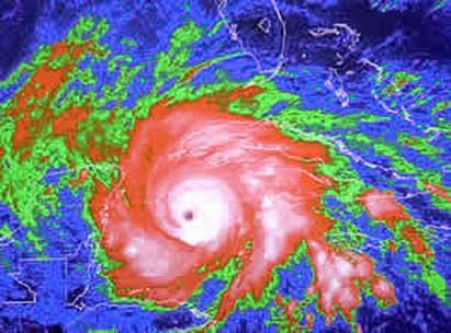
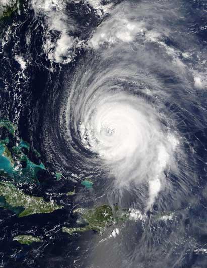
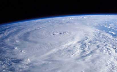
The air that is located in the center of the hurricanes is much hotter than the environment. As mentioned above, it receives energy from condensation of water vapor. The marine water vapor expands and ascends rapidly. As the temperature in the upper layers of the atmosphere is not so high, the steam is condensed. In this process, in addition to forming large clouds full of rain, a lot of energy is released. In the satellite images shown in the weather predictions of television, these phenomena are perfectly perceived.
In the lower areas of the hurricanes, about 3,000 meters away, the air is absorbed into the interior of the hurricane. In the central areas, the wind revolves around the center of the hurricane and ascends. Finally, at the top, the air moves outward from the hurricane.
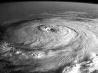
Undoubtedly, the most famous feature of hurricanes is, if it's just listening, the eye of the hurricane. This eye is a "peaceful" area located in the center of the hurricane. It extends from the sea level to the high part of the hurricane, surrounded by a wall of dense rain mists. Inside the eye, the temperature and wind are very hot, so the evaporated water rises rapidly. This creates a very dry environment, unable to condense, without fog. This is what really draws attention to seeing satellite images.
The bigger the hurricane, the cleaner the eye looks. However, a great eye does not mean that the hurricane is large, although it may occur. That has nothing to do with it. On the walls of the eye are two opposing forces: the wind force that moves towards the center and the centrifugal force that pulls out. The strongest winds move there, on the walls of the eye.
Curiosities - Curiosities
- When we talk about small hurricanes, we talk about hurricanes 150 kilometers wide.
- Hurricane Tip of 1979 had a radius of 1,100 kilometers.
- There is no direct relationship between the size of the hurricane (radius in kilometers) and force (wind speed).
- The damage caused by hurricanes depends on the speed of the wind.
- They can cause waves of up to 18 meters in the sea.
- They can last more than a week.
- In 1994 Hurricane John was 31 days old.
- We speak of hurricane, but elsewhere they speak of typhoons or cyclones to say the same.
- When hurricanes reach the continent, they lose strength by stopping to take fuel, water from the sea.
- The eye of the hurricane is "peaceful," the sky can also be seen blue, but the hurricane has more force around.
- The eye can measure between 8 and 200 kilometers.
- Hurricane Tip marked the lowest atmospheric pressure of all time, 870 millibar, causing a wind of 165 kilometers per hour.
- The deadliest hurricane was the one that struck Bangladesh in 1970, with 300,000 dead.

Name of the hurricanes
This habit of naming hurricanes is curious. Here not so much, since most of the names are external, but when the hurricane gets its own name, that of marriage, or that of some acquaintance, it opens the gap for the joke.
But it has not always been so. Before they were given no common name. Before, the presence and importance of religion in marine life was such that when a spectacular discovery or a terrible event occurred, it was given the name of Saint Mary Catholic. The hurricane was also included among surprising facts.

This system of registration of hurricanes only lasted a few years. In fact, every year many hurricanes occurred on the same date. Thus, there was more than one hurricane called Felipe, Bixente, Roke... To solve the problem, they decided to ignore the nomenclator of the Saints and use the common name.
Use of feminine names XIX. Australian meteorologist Clement Wragge established at the beginning of the century. Despite the subsequent changes, in 1953 the U.S. Meteorology Service began to give hurricanes to women in alphabetical order. In 1978, for their part, they decided to intercalate the names of men.
At present, the World Meteorology Organization has 6 lists in which the names of women and men are interspersed for rotating use and in alphabetical order. Each of these lists is used every year, so in the seventh is repeated, but the names of the affected hurricanes are removed and replaced by another one that begins with the same letter. Thus, Andrews, Hugo, Opal, Roxanne... are already out of this list. This year's season began with Ana, Bill and Claudette. The names of the new hurricanes will be as follows: Danny, Erika, Fabian, Grace, Henri, Isabel, Juan, Kate, Larry, Mindy, Nicholas, Odette, Peter, Rose, Sam, Teresa, Victor, Wanda.
Published in section D2 of Deia.

Gai honi buruzko eduki gehiago
Elhuyarrek garatutako teknologia