


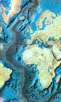
Underwater mountain ranges: dorsal
The dorsal, the underwater mountain ranges, are little known to the public. This ignorance is a direct consequence of a series of factors, on the one hand because we do not see them and, on the other, because until recently geologists and experts on these subjects knew little. However, to say that we do not see them is not quite true; Iceland, for example, is a portion of dorsal that leaves on the water and, on the other hand, because the origin of many earthquakes is in the dorsal areas and, at least, we perceive them.
A few years ago, with the approval of the theory of plate tectonics and the advance of technology, a great step was taken in the research of the dorsal, although there are still many points pending. For example, today we know that the dorsal ones form the longest mountain range of the Earth, traveling almost the entire Earth along 75,000 kilometers; that they emit eight times more lava than all the volcanoes of the planet forming an oceanic crust; that they cool through the traffic of marine waters filtering for millions of years all the water of the sea; that can be cause of transgression, etc.
In the following pages we will discuss the dynamics of dorsal and the expansion of marine soil closely linked to it.
Plate tectonics
To understand the dorsal dynamics it is necessary to know the basics of plate tectonics. Although we do not go too deep, we will try to explain in the simplest way possible what this theory consists of.
Wegener (1880-1930) first postulated the theory of continental drift. According to this theory, the continents float on an ocean surface weaker than dense (like ice on water). Thus, according to Wegener, the continents move in a time forming a supercontinent called Pangea, although all were together. This theory was not accepted until it was tested by Zenpaleomagnetism, after Wegener's death.
Thus, the theory of continental drift was approved, which, despite its movement, has already been explained by scientists through plate tectonics.
Two types of lithosphere (terrestrial surface plus top mantle) are distinguished: continental (low density) and oceanic (denser). Its origin is different and is formed by different rocks. Lithospheric movements are produced on a more plastic astenosphere. As has been said above, the continents move, but not as continents, that is, the plates move. The Earth is formed by plates or, what is the same, the lithosphere is divided as pieces of a puzzle, in some of which there are continents and oceanic bark, in others only the oceanic crust (see figure 1).
Taking into account all this, the problem that arises and that has given great headaches is: if the entire surface is formed by plates, how do movements occur? All these pieces of the earth's crust can act as conveyor belts: in the dorsal areas a new ocean surface is formed, a process in which each plate moves away as explained later. In order for this new surface to fit, the old surface should disappear elsewhere, in the subduction zones.
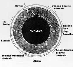
Figure 2 shows these movements quite well. In this second image we can see the convection currents of the mantle, of which there are still hypotheses about its origins and directions, being that of the image one of the most accepted. As can be seen, the ascending currents of the upper mantle form an oceanic crust in the dorsal ones. Consequently, the two plates related to this dorsal leave in the opposite direction “sliding” them over the astenosphere (as indicated by the external arrows in the sphere).
The oldest lithospheric material, the farthest from the dorsal, disappears in the subduction zones related to the descending currents of the mantle (like the Chilean fossa). In this way, the lithosphere is formed and constantly disappears. The case of Hawaii is special. In this case, the material of the mantle rises inside a plate, forming a volcano from which the material of the mantle leaves.
The following images show the different fields that appear in figure 2.
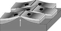
The third figure corresponds to the subduction areas. The oceanic plate is introduced under the continental because it is denser or oceanic under the oceanic. This occurs “spontaneously” when the oceanic lithosphere is ancient (200 million years), since in aging it becomes denser, reaching a density greater than the astenosphere (remember that the lithosphere moves on the astenosphere). This subduction or sinking is “natural” so small earthquakes occur.
However, when the two plates have an opposite direction and both have continents, when colliding it gets into force, as seen in the first case of the figure, when very violent earthquakes and volcanoes occur because the oceanic lithosphere is still too light to form the subduction, that is, because the astenosphere has a higher density than that oceanic plate. As the subduction is formed, the continental surface rises as seen in the figure and, therefore, mountain ranges related to the subduction areas, such as the Andes, are formed. In the case of two plates with opposite direction, they will collide and between them will form a mountain chain, formed by two plates. This is the case of the Himalayas, formed by the clash of India with the Eurasian plate. You can see this case in figure 4.
Figure 5 shows a simple scheme of the dorsal ones. The arrows indicate the movement of the plates, that is, the plates that move in the formation of the new terrestrial surface, where the undeniable proof that the continents move, by measuring the previously mentioned magnetic anomalies or paleomagnetism, was discovered. The other features will be displayed in the following points.
Topography of dorsal and underwater geology
As a result of erosion, continental topography changes constantly. In the submarine, however, erosion has little importance and the reliefs that are seen are very similar to the originals, so they have an immediate geological meaning and are very useful for interpretation.
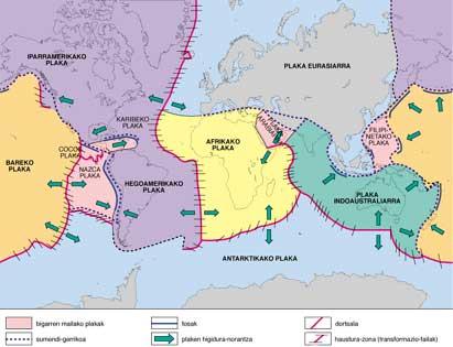
The oceanic dorsal are long, wide and continuous exaltations of marine bottoms of a thousand kilometers wide (foot -5,000 m and summit -2,500 m) forming more than a third of the ocean. On the map of Figure 5 we can see that almost the entire Earth is surrounded by continental rift, elements of the same expansion system.
On the other hand, as can be seen in Figure 5, the summit is fragmented by a valley called oceanic rift due to its characteristics similar to those of the continental rift, such as eastern Africa. However, this valley does not appear in all dorsal areas, since two types of dorsal can be distinguished depending on the speed of propagation: slow dorsal, with an expansion speed of 1 cm/year (for example, the Atlantic) and fast, extending to 20 cm/year (for example, the Pacific). In the latter, no ocean rift is distinguished.
Among the other features stands out the presence of transformable failures. Figure 6 shows the movement of the dorsal ones. These failures are the cause of many earthquakes.
Continental and oceanic rift
So far, we have only said that they participate in the same dorsal diffusion system. But what are they? They also receive the name Rift-valley and, in short, are the long and narrow depths that surround the steep and straight slope that arises from the formation of faults on the terrestrial surface. They are very similar to slow dorsal. Currently there are two systems of rift active occasionally: Jordan Valley and the East African rift system.
You can see how these rift form in figure 7. In the first stage, an abombamiento of the terrestrial surface occurs due to the ascending currents of the mantle. In the second stage, the domes resulting from the distension forces that are to be produced are succeeded.
In this stage, the rift is very similar to the dorsal ones (the same ascending currents of the mantle, the same forces of distension, etc. ). ). In the following stages, the formation of oceanic surfaces will increase, increasingly distancing the two continental parts. When sufficient ocean surface has been formed, the sea enters. While the rift is active, the ocean surface will be formed and the sea will become increasingly deeper. The final result of this whole process will be the two continents separated by a sea.
Hydrothermalism of dorsal and “Black Smoker”
In 1979, American diving Alvin discovered in the eastern dorsal of the Pacific Ocean the small oasis formed by crabs, clams and other creatures in the middle of black water that poured a fireplace. For this reason, they approached the hottest areas of the dorsal and many other hydrothermal springs were discovered, both in the Pacific dorsal and in the Atlantic. As we have seen a posteriori, this hydrothermal circuit that cools the dorsal ones explains why the thermal anomalies measured around the dorsal ones.
These hot sources of black water from the Eastern Pacific are called “Black smoker”. The temperature of these waters is 350 °C and is explained by its richness in metallic sulphides. The calors and mineral salts that emerge from the smerres of Black contribute to the proliferation of bacteria that in turn facilitate the spread of live colonies.
As mentioned above, faults cross dorsal lines. From these faults penetrates the water of the sea and can reach up to 2-3 km of surface, where it heats to 400-500 °C and rises again coming out of smoker. In this ascending journey, the hot water partially dissolves the rocks that form the earth's crust, enriching the water in the metals. Then, when leaving the smon black and cool, the dissolved precipitates forming mineral deposits, mainly of cuprés.
Other possible consequences of hydrothermalism are still being investigated. However, the importance of this process is undeniable if we take into account that only for about millions of years can all sea water be recycled.
Did life arise around the dorsal ones?
It seems that the physical conditions around black smokers are appropriate for the inorganic synthesis of animoacids and other prebiotic molecules. In addition, very primitive cells have been found around them. On the other hand, these are the only areas of the Earth in which, instead of extracting energy from the Sun through photosynthesis, it is extracted from the interior of the Earth by oxidizing reduced sulfurated compounds.
Methods of analysis of dorsal
The enormous size of the dorsal and the flood are great obstacles to research, hence, until recently, they have not been investigated. Fortunately, technological advances have facilitated the knowledge of the dorsal.
The techniques used are surveys, diving, seismic profiles, measurements of thermal anomalies and measures of gravimetric anomalies, among others. But all of them are very expensive and, except for diving, the rest only provides indirect information. That is, we have to interpret the data and that has a great risk.
The most famous dive is Nautile. Through it they were interned in a fault and managed to perform a cross section of the oceanic crust. This cross section has a great geological significance since each rock is formed in particular conditions. For example, Philonian complexes are indicators of the ascending channels of mantle materials. But there is an older and cheaper research system: the investigation of ofiolites. The ofiolites are fragments of ancient ocean surfaces located on the continental crust. Being out of the water it is possible to see the ocean surface without diving.
The greatest information on the ocean surface has been obtained from the research of the following. The process of formation of the oceanic surface on the continental one is called obduction. This has been schematically represented in figure 9 from the Omani model. In fact, it is the most studied opera house, Omango, for being the largest, and for the lack of vegetation, for its unbeatable outcrop, which can be seen in its entirety. In addition, unlike most of the operolites, the convergence of the plates has not ended and the continents that carry them have not yet collided. It is calculated that they will collide a couple of millions of years, which will provoke the formation of a mountain range like the Alps between the Arab and Eurasian plate and the break of the entire Ofiolite, eliminating the footprint of the sea existing among the icontinents.
Buletina
Bidali zure helbide elektronikoa eta jaso asteroko buletina zure sarrera-ontzian


