Urban lighting maps, pollution indicators
Thanks to information obtained via satellite, scientists can produce urban light maps that allow measuring the density and degree of pollution of urban nuclei. In addition, the maps of light can be used to know the state of the organization of the territory.
I have a friend who likes nature and the rhythm of nature. "This is not the way to live on more than one occasion, we are against Nature. The night wakes up and the day goes sleeping us. And we are not the only ones who are crazy, the animals have also started to go crazy." When it starts like this I know that it is not crazy cows, but txantxangorri. "At four in the morning he also sings."
There is no lack of reason. And it is that the nights of towns and cities are not like years ago. Until the electric lighting was installed in the streets, people lived differently, especially looking at the Sun. When the people were leaving, they woke up and rose up, while when they were hiding they were on their way to the bed or to the house. However, today, many people do not realize when the sun comes out and when it gets down. "The txantxangorriak don't realize either, they spend the night as a day," his friend would say.
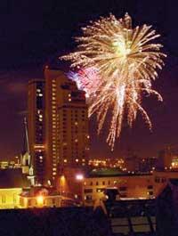
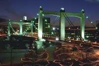
According to all scientists, cities are the meeting point for numerous types of pollution. The rivers that cross the cities are usually very dirty, the sky is usually full of smoke, they are noisy… and the impact of light pollution is becoming more and more evident. As a consequence of all this, cities constitute an important factor of imbalance of nature, especially in terms of the state of ecosystems and climate. Faced with this problem of contamination, a group of scientists has developed techniques and systems to measure the density of the cities of the world. In addition to the measurement, the system explains how it affects the density of cities to Nature.
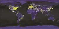
The technique does not seem complicated. Taking advantage of the large number of satellites found in the orbit of the Earth, scientists take pictures of the cities at night. In this way they can make light maps of the world. These light maps show the differences of luminosity that exist from one point to another, thus forming the degree of urbanization of some and other spaces. This reading of the urbanization level will serve as a basis for the subsequent analysis of its environmental impact.
At NASA's Goddard Space Flight Center they work with this technique. The team led by biologist Marc Imhorff has completed six years of research to learn about the degree of urbanization and its influence on nature. To carry out the research, as indicated, the Goddard center is served by satellites in orbit. When it is dark, satellites receive light. Of course, in the images the light of the cities appears mainly, so that the satellites see it because the concentration of light is necessary.
Taking into account the data obtained in these studies, the researchers of the group Marc Imhofrfen have also dared to make theories about the consequences of the level of urbanization. According to the researchers, the migratory movements towards the cities are growing worldwide, that is, there are fewer and fewer people outside the cities. According to the data provided by the researchers of the Goddard center, until two years ago only a third of the population of the planet lived in the cities, while currently the population is half and a half, half live in large cities and the other half out of them.
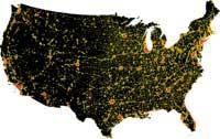
The conclusion is, undoubtedly, more interesting than the own insurance technique, which lacks unique secrets. However, the motivations for the use of this technique and the development of research, especially from the point of view of those who want to coexist with the rhythm of Nature, can give time to reflection. The words belong to the director of the research, biologist of Marc Imhorff. "I have spent a lot of time looking at Earth from space, and what has surprised me most is how human development has spread, which has spread as mold advances in oranges. It seemed important to me to know how this development would affect the environment, especially in the environment and in the landscape. I thought I had to cover all the urbanized spaces and make a map, but for it was essential a concrete image of all the cities. Of course, that was a great job, until I realized that there is something that all the cities of the world have, electricity." From that theory or desire, with the initiative of Imhorff, he decided to take advantage of the work of satellites to capture images of the illuminated world spaces. This has allowed you to start making light maps. At the moment, the maps are mostly from the United States, but it is expected to later map light from around the world.
Is there a need to work in this regard? It is difficult to give meaning or not to the question, especially knowing that the recent trend is that more and more people are approaching cities. However, it is not bad to report the environmental problems that this can generate, even though only by knowing it people will hardly fail to adapt to cities. The maps of light can be clear and precise exponents of the evolution of cities, since the cities illuminated from the sky are easily seen, while from the earth it is increasingly difficult to see the dark sky, the stars of the sky and the moon itself.
Published in 7
Buletina
Bidali zure helbide elektronikoa eta jaso asteroko buletina zure sarrera-ontzian