History of a Marine Eruption
In
October 1997, two geologists from the University of Oregon placed a unique and sophisticated instrument (rumbleometer) on the volcanic line stretching 500 km off the Oregon coast. This special device is able to accurately measure ocean depth, ocean currents and temperature alongside volcanoes. Both geologists have studied Oregon's volcanic line for 15 years and in 1997 they wanted to investigate the remaining movements on the seabed before the eruptions. In that sense, in 1998, an unexpected eruption hit the measuring apparatus, but the instrument did not spoil and managed to make the most complete picture of the eruption of an underwater volcano.
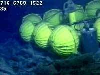
The 1998 eruption was laminar, that is, the lava slowly expanded in the form of a layer and covered several square kilometers before the ends were cooled and hardened. Fortunately, the lava did not drag the meter and the process could be tracked. As published in the journal Nature, this surprise has allowed researchers to conclude that the theoretical models of the eruptions of marine volcanoes are correct.
The rash step by step
Initially the lava layer expanded slowly, but due to the enormous heat absorption capacity of the water, the apparatus only measured a temperature rise of 4°C to one meter of incandescent lava. The top of the layer cooled and hardened quickly and then began an even more shocking show. Due to the pressure exerted by lava flowing constantly through the volcanic line, it began to swell like a globose layer and reached a height of 3.5 meters in an hour. Subsequently, it began to contract, as the lava found the way out of the cracks created in the solid layer or down again in the volcano. Two and a half hours after the beginning of the phenomenon, the level of the seabed reaffirmed, but one meter above the original situation.
Buletina
Bidali zure helbide elektronikoa eta jaso asteroko buletina zure sarrera-ontzian