Belinda on ice
Montdugu Island does not appear on any map until 1775. That same year, the British expedition led by James Cook saw several islands and one of them was given the name of Montdugu. The island rises 3,000 meters from the ocean bottom and has a main summit, Belinda. The summit has a height of 1.370 meters and is a volcano. The mountain is formed by eruptions of tens or hundreds of thousands of years, formed by ashes poured by the volcano and a solidified lava.
Belinda was long asleep. But in 2001, the organization MODVOLC, which controls the ‘hot spots’ of the world, gave notice: Belinda was getting lazy and since then her activity has been growing. For scientists, this eruption, which is taking place under ice, is really interesting. This allows them to analyze the interaction between lava and ice.
Belinda's activity is being monitored by NASA's Terra satellite. Spend a couple of times a day and twice a month take photos of high resolution using an ASTER radiometer that detects the emission and reflection of the heat.
An exciting eruption
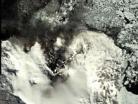
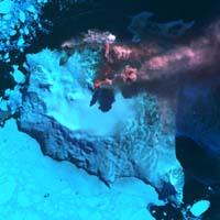
In the images of a year ago it is seen that Belinda was awake. (Photo: Spaceimaging)
The image taken on September 23 has been colored by NASA. In this way, the volcano and its surroundings are easily separated. The hot areas appear in red, the snow in blue, the steam in white and the volcanic ash in gray.
Rarely can we see something like this, so it is understandable that the geologist of the British organization studying the Antartic Survey of Antarctica is revolutionized. When lava comes into contact with the ice, among other things, they want to analyze how the rocks and their characteristics form.
In addition, they are eager to study the influence of so much ice melting. Scientists have a reference: In 1996, in Iceland, under a Gjálp glacier, a small eruption occurred. When the ice melted into the ocean, it was the largest fresh water flow received by the oceans, after the Amazon. Undoubtedly, it caused important changes in the environment.
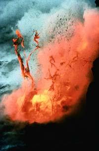
On this occasion, the incidence will be even more pronounced, since the eruption is greater than that of then. The lava flow reaches the sea from the top of Belinda. In fact, the lava begins to the northeast of the summit, but then a steep ridge directs it to the north. The lava river has a total length of three and a half kilometers and has a width of 90 meters to one kilometer from the summit. When arriving to the sea Laba is formed a water vapor that is clearly perceived from space.
Slope of flight
The South Sandwich islands are one of the most remote territories with volcanic activity. As a result, so far, few investigations have been conducted on them. Now they have the help of the satellite, but the curiosity of scientists is insatiable and want to get closer images. For this purpose, they plan to pass by plane above the volcano to record the eruption as close as possible.
The images taken from the plane will be especially valuable to scientists who will allow them to closely investigate the geology of those distant icy regions. But, besides geologists, they will be of interest to all others; to see free the force of Nature always generates emotion.
Published in 7K.
Buletina
Bidali zure helbide elektronikoa eta jaso asteroko buletina zure sarrera-ontzian